
Scharnegoutum
Scharnegoutum
Skearnegoutum | ||
|---|---|---|
Village | ||
 | ||
|
Postal code 8629[1] | ||
| Dialing code | 0515 | |
| Website | Official | |
Scharnegoutum (
Friesland, the Netherlands. It had a population of around 1,660 in January 2017.[3]
History
Scharnegoutum is built upon a man-made hill (called a
terp in Dutch). During excavations of the hill objects from the 4th century were found. The village was at one time beside the Middelzee until this was drained in about 1300. In the Middle Ages Scharnegoutum possessed a covenant, similar to the situation in the villages Loaiïngea, Goaiïngea, Gau, and Offingawier
.
Scharnegoutum had a train station from 1883 until 1938, on the railway line Leeuwarden - Stavoren. On June 1, 1940 the station reopened, but on November 24 of that year it closed again. In 1897, the Dairy Cooperative factory Scharnegoutum was founded. In 1972 this factory was closed. Before 2011, the village was part of the Wymbritseradiel municipality.
Population
- 1954 - 1,031
- 1959 - 1,002
- 1964 - 955
- 1969 - 1.020
- 1974 - 996
- 2006 - 1,677
Gallery
-
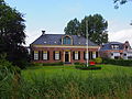 Villa in Scharnegoutum
 -
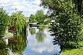 Canal view
 -
 Villa in Scharnegoutum
 -
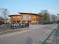 School in Scharnegoutum
 -
 Memorial at Martens' church


.JPG)
References
- ^ a b c "Kerncijfers wijken en buurten 2021". Central Bureau of Statistics. Retrieved 6 April 2022.
two entries
- ^ "Postcodetool for 8629EA". Actueel Hoogtebestand Nederland (in Dutch). Het Waterschapshuis. Retrieved 6 April 2022.
- ^ Kerncijfers wijken en buurten 2017 - CBS Statline
External links
![]() Media related to Scharnegoutum at Wikimedia Commons
Media related to Scharnegoutum at Wikimedia Commons
| International | |
|---|---|
| National | |