
Garfield, Colorado
Garfield, Colorado | |
|---|---|
MDT) | |
| ZIP Code[4] | Salida 81201 |
| Area code | 719 |
| GNIS feature ID | 2583238[2] |
Garfield is an
Zip Code 81201) serves the area.[4]
Geography
The Garfield CDP has an area of 218 acres (0.883 km2), all land.[1]
Demographics
The
United States Census 2010
.
| Year | Pop. | ±% |
|---|---|---|
| 2010 | 15 | — |
| 2020 | 27 | +80.0% |
| Source: United States Census Bureau | ||
Attractions
- Monarch Mountainski and snowboard area
- Monarch Pass
- San Isabel National Forest
See also
- Outline of Colorado
- State of Colorado
- Colorado cities and towns
- Colorado census designated places
- Colorado counties
- San Isabel National Forest
- Monarch Ski and Snowboard Area
References
- ^ a b c "State of Colorado Census Designated Places - BAS20 - Data as of January 1, 2020". United States Census Bureau. Retrieved December 20, 2020.
- ^ a b "Garfield Census Designated Place". Geographic Names Information System. United States Geological Survey, United States Department of the Interior. Retrieved July 30, 2023.
- ^ a b United States Census Bureau. "Garfield CDP, Colorado". Retrieved April 10, 2023.
- ^ a b "Zip Code 81201 Map and Profile". zipdatamaps.com. 2020. Retrieved December 20, 2020.
External links
Garfield, Colorado at Wikipedia's sister projects
 Definitions from Wiktionary
 Media from Commons
 News from Wikinews
 Quotations from Wikiquote
 Texts from Wikisource
 Textbooks from Wikibooks
 Resources from Wikiversity
- Garfield @ GhostTowns.com
- Chaffee County website
- Monarch Mountain website
- San Isabel National Forest website
Municipalities and communities of Chaffee County, Colorado, United States | ||
|---|---|---|
| City | 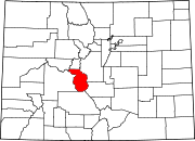 | |
| Towns | ||
| CDPs | ||
| Unincorporated communities | ||
| ||