
Garyp
Garyp
Garijp | ||
|---|---|---|
Village | ||
 St Peter's Church | ||
|
Postal code 9263[1] | ||
| Dialing code | 0511 | |
Garyp (Dutch: Garijp[3]) is a village in the municipality of Tytsjerksteradiel within the province of Friesland, Netherlands. It had a population of around 1,894 in January 2017.[4]
History
The village was first mentioned between 1325 and 1336 as Garipe and means "village of the river bank".
Garyp was home to 620 people in 1840.[7]
Gallery
-
 Village view
 -
 Farm Binnenrust
 -
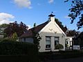
House in Garyp
-
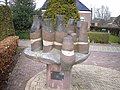 Village community statue


References
- ^ a b c "Kerncijfers wijken en buurten 2021". Central Bureau of Statistics. Retrieved 5 April 2022.
two entries
- ^ "Postcodetool for 9263AA". Actueel Hoogtebestand Nederland (in Dutch). Het Waterschapshuis. Retrieved 5 April 2022.
- ^ Taalunie (2019). "Friese namen" (in Dutch). Retrieved 18 November 2019.
- ^ Overzicht inwonersaantal Tytsjerksteradiel - Tytsjerksteradiel
- ^ "Garyp - (geografische naam)". Etymologiebank (in Dutch). Retrieved 5 April 2022.
- ISBN 90 400 9476 4. Retrieved 5 April 2022.
- ^ a b "Garyp". Plaatsengids (in Dutch). Retrieved 5 April 2022.
Wikimedia Commons has media related to Garyp.
| Administrative Centre |  | |
|---|---|---|
| Villages |
| |
| Hamlets | ||
| Landmarks |
| |
| Lakes | ||
| Authority control databases: National |
|---|
This Friesland location article is a stub. You can help Wikipedia by expanding it. |