
Genesee River
| Genesee River | |
|---|---|
 Genesee River near Belmont | |
 Map of Genesee River | |
| Native name | Čunehstí•yu• (Tuscarora)[1] |
| Location | |
| Country | United States |
| State | New York, Pennsylvania |
| Counties | (see Navbox, below) |
| City | Rochester, NY |
| Physical characteristics | |
| Source | |
| • location | Ulysses Township, Potter County, Pennsylvania |
| • coordinates | 41°53′33″N 77°43′54″W / 41.89250°N 77.73167°W[2] |
| • elevation | 2,275 ft (693 m)[3] |
| Mouth | Lake Ontario |
• location | Charlotte, Rochester, Monroe County, New York |
• coordinates | 43°15′30″N 77°36′08″W / 43.25833°N 77.60222°W[2] |
• elevation | 243 ft (74 m)[2] |
| Length | 157 mi (253 km) |
| Basin size | 2,500 sq mi (6,500 km2) |
| Discharge | |
| • location | Lake Ontario |
| Discharge | |
| • location | Portageville, NY |
The Genesee River (/ˌdʒɛnɪˈsiː/ JEN-iss-EE) is a tributary of Lake Ontario flowing northward through the Twin Tiers of Pennsylvania and New York in the United States. The river contains several waterfalls in New York at Letchworth State Park and Rochester.
The river was historically used as a border between the lands of the Seneca to the east and the Erie and Wenro to the west. Later, the river provided the original power for the Rochester area's 19th century mills, and still provides hydroelectric power for downtown Rochester. Flooding occurred periodically in the river valley before construction of the Mount Morris Dam in the 1950s.
Geology

The Genesee is the remaining western branch of
During the past million years, four glacial ages covered the Rochester area. The southern edges of the Laurentide Ice Sheet and those advances impacted the formation geology and geography of the area. The most recent glacier that left evidence here was about 10,000 years ago and it caused compression of the earth by as much as 2,500 feet (760 m).[9] About 12,000 years ago, the area underwent massive changes, which included the rerouting of the Genesee and other water bodies. The pre-ice age eastern branch of the Genesee runs south of Mount Morris and was completely diverted by extensive terminal moraines in Livingston County with a key blocking dam just south of Dansville, so most of the upper section of the ancient river was diverted instead to fall the off Appalachian Plateau toward the Susquehanna River system (to an eventual destination well to the southeast).
Only a small creek (Irondequoit Creek) flows in what is left of this large paleogeologic valley. The area of the lower river was also affected. Since the earth rebounded from the melting glaciers more rapidly in Canada than in New York, water from Lake Ontario was spilled over New York due to its lower elevation. During this time, the original outlet of the Genesee River, Irondequoit Bay, was flooded out, creating the current bay. As these waters later retreated, glacial debris caused the river to be rerouted to the west along its current path.[10][11]
History
The
Historically, the river's gorge formed a clearly demarcated border between the lands of the
On Friday, November 13, 1829 (Friday the 13th), the daredevil Sam Patch jumped to his death before 8,000 spectators at the Upper Falls in Rochester.
If "not for hydropower, the flour mills, clothing mills, and tool fabricators would not have located in Rochester",
In 1836 the
In 1852 a wooden railroad bridge was built over the Upper Falls at Portageville. It was the largest of all wooden bridges built at the time.[citation needed] The wood from 300 acres (1.2 km²) of trees was required for its timber. In the "summer of 1943", Arch Merrill walked the length of the Genesee River.[16]
Serial killer Arthur Shawcross dumped most of his victims in or near the river, leading to him being nicknamed "The Genesee River Killer".[17]
Crossings
Floods
A March 1865 thaw was the worst Genesee flood in Rochester history, and a similar 1913 flood motivated the excavation of the Genesee's rock bed in Downtown Rochester. The 1972 Hurricane Agnes flood broke all county historical records, with the most concentrated damage in the Wellsville area.[18][19] The water from Hurricane Agnes caused the only instance where the river's flow exceeded the storage capacity of the reservoir of the Mount Morris Dam, the largest flood control dam east of the Mississippi, and water had to be released from the dam to prevent overtopping of the spillway.
-
 A View of the Casconchiagon or Great Seneca Falls, Lake Ontario, taken 1766 by Thomas Davies
 -
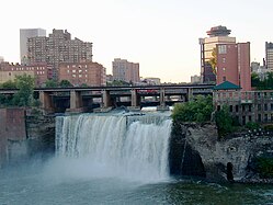 TheHigh Falls in downtown Rochester
 -
 The Middle Falls in Letchworth State Park
 -
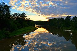 Genesee River in the Town of Caneadea


Literature
The Genesee has been the subject of books and poetry:
- Valley of the Genesee: A Poem by Charles Edwin Furman (1879)
- By the Genesee: Rhymes and Verses by Thomas Thackeray Swinburne (1900)
- Genesee Fever by Carl Carmer (1941); a novel about the early settlement of the Genesee Valley.
- A River Ramble: Saga of the Genesee Valley by Arch Merrill (1943); a walk along the Genesee from its source to its mouth.
- The Genesee by Henry W. Clune (1963); part of the Rivers of America Series
See also
References
- Seneca tribe name Chin-u-shio (Tuscarora language) meaning a beautiful open valley.
- ^ a b c U.S. Geological Survey Geographic Names Information System: Genesee River
- ^ Harrison Valley, PA, 7.5 Minute Topographic Quadrangle, USGS, 1957 (1971 rev)
- ^ a b Letchworth State Park, accessdate=2016-06-05
- ^ Such layers often allow carbon-14 dating to synchronize subdisciplines of stratigraphy
- ^ High falls & Browns race area, City of Rochester, accessdate=2016-06-05
- ^ downtown falls area, City of Rochester, accessdate=2016-06-05
- ^ MAPLEWOOD/LOWER FALLS - Rochester, NY, accessdate=2016-06-05
- ^ "Geology: 100,000 years ago". Rochester's History: An Illustrated Timeline. Archived from the original on 2008-06-03. Retrieved July 11, 2008.
- ^ "Geology: 12,000 years ago". Rochester's History: An Illustrated Timeline. Archived from the original on 2008-06-03. Retrieved July 11, 2008.
- .
- Dobson's Encyclopedia volume 3, which cites Jedidiah Morseas its source, probably the American Gazetteer, 1795
- ISBN 9780815630968. Retrieved May 8, 2017.
- ^ Quigley, Kellen (December 31, 2022). "Seneca Nation purchases ancestral Genesee Valley land". The Salamanca Press. Retrieved 2022-12-31.
- ISSN 0035-7413. Retrieved December 29, 2009.
Hydropower has never contributed more than two and a half percent of the total energy supply of Rochester
- ^ Merrill, Arch (1943). "A River Ramble: Saga of the Genesee Valley". GenWeb, Monroe County, NY. Retrieved November 26, 2009.
- (see also: "Rediscovering the Rambling River". Democrat and Chronicle.[permanent dead link])
- ^ "27 Gruesome Facts About 'The Monster of the Rivers' (AKA Arthur John Shawcross)". 18 March 2018.
- ^ "HURRICANE AGNES and the GENESEE RIVER FLOODING". NWS Eastern Region Headquarters. Retrieved December 18, 2009.
- ^ "The great flood of 1972". Star-Gazette. Elmira, New York: Gannett. 1972. p. 63.
External links
- . The American Cyclopædia. 1879.
| International | |
|---|---|
| National | |