
Gheorgheni
Gheorgheni
Gyergyószentmiklós | |
|---|---|
 | |
 Flag  Coat of arms | |
 Location in Harghita County | |
 Gheorgheni Location in Romania | |
| Coordinates: 46°43′12″N 25°35′24″E / 46.72000°N 25.59000°E | |
| Country | Romania |
| County | Harghita |
| Government | |
| • Mayor (2020–2024) | Tibor Csergő[1] (UDMR) |
| Area | 90.17 km2 (34.81 sq mi) |
| Elevation | 816 m (2,677 ft) |
| Population (2021-12-01)[2] | 15,884 |
| • Density | 180/km2 (460/sq mi) |
| Time zone | EET/EEST (UTC+2/+3) |
| Postal code | 535500 |
| Area code | (+40) 02 66 |
| Vehicle reg. | HR |
| Website | www |
Gheorgheni (Romanian pronunciation: [ɡe̯orˈɡenʲ]; Hungarian: Gyergyószentmiklós Hungarian pronunciation: [ˈɟɛrɟoːsɛntmikloːʃ] ⓘ) is a municipality in Harghita County, Romania, with a population of 15,844, as of 2021. It lies in the Székely Land, an ethno-cultural region in eastern Transylvania. The city administers four villages: Covacipeter (Kovácspéter), Lacu Roșu (Gyilkostó), Vargatac (Vargatag), and Visafolio (Visszafolyó).
Geography
The city is located in the northeastern part of Harghita County, 57 km (35 mi) north of the county seat,
History

Gheorgheni historically formed part of the
In the aftermath of World War I, the Union of Transylvania with Romania was declared in December 1918. At the start of the Hungarian–Romanian War of 1918–1919, the town passed under Romanian administration. After the Treaty of Trianon of 1920, it became part of the Kingdom of Romania and fell within Ciuc County. In 1940, the Second Vienna Award granted Northern Transylvania to Hungary. Towards the end of World War II, Romanian and Soviet armies entered the town in October 1944. The territory of Northern Transylvania remained under Soviet military administration until March 9, 1945, after which it again became part of Romania. Between 1952 and 1960, Gheorgheni was part of the Magyar Autonomous Region, and between 1960 and 1968 part of the Mureș-Magyar Autonomous Region. After the administrative reform of 1968, the region was abolished, and since then, the city has been part of Harghita County.
Demographics
Ethnic composition of Gheorgheni municipality
The confessional composition of the municipality of Gheorgheni
At the 2021 census, Gheorgheni had a population of 15,884.[3] At the 2011 census, the city had a population of 17,705, of which 86.13% (15,250) were Hungarians and 1,988 (11.22%) Romanians.
Demographic movement according to the censuses:

For Armenian Catholics, see Ordinariate for Armenian Catholics of Romania.
Politics
The town council has 19 members as follows:
| Party | Seats | Current Council | |||||||||||
|---|---|---|---|---|---|---|---|---|---|---|---|---|---|
| Hungarian Civic Party (PCM/MPP) | 10 | ||||||||||||
| Democratic Alliance of Hungarians in Romania (UDMR/RMDSZ) | 6 | ||||||||||||
| Independent politician | 2 | ||||||||||||
| National Liberal Party (PNL) | 1 | ||||||||||||
Natives
- Zsolt Antal (born 1972), cross-country skier
- Mihály Fogarasy (1800–1882), bishop of the Catholic Church
- Réka Forika (born 1989), biathlete
- Ștefan Gal (born 1951), gymnast
- Mónika György (born 1982), cross-country skier
- Tímea Lőrincz (born 1992), cross-country skier
- Katalin Marosi (born 1979), tennis player
- Endre Molnár (born 1945), water polo player
- Pál Sajgó (1922–2016), cross-country skier and biathlete
- László Sólyom (born 1955), ice hockey player
- Virgil Șotropa (1867–1954), teacher, honorary member of the Romanian Academy
- Ágnes Szatmári (born 1987), tennis player
- Csaba Szekely (born 1990), ice hockey coach and goaltender
- László Tamás (born 1988), footballer
- Elemer-György Tanko (born 1968), cross-country skier
- Andrei Țepeș (born 1991), footballer
Twinnings
 Békés, Hungary
- Budapest 17th District, Hungary
- Cegléd, Hungary
- Eger, Hungary
- Kiskunmajsa, Hungary
- Siófok, Hungary
- Szigetszentmiklós, Hungary
 Bačka Topola, Serbia
 Alaverdi, Armenia
References
- ^ "Results of the 2020 local elections". Central Electoral Bureau. Retrieved 9 June 2021.
- ^ "Populaţia rezidentă după grupa de vârstă, pe județe și municipii, orașe, comune, la 1 decembrie 2021" (XLS). National Institute of Statistics.
- ^ "Populația rezidentă după grupa de vârstă, pe județe și municipii, orașe, comune, la 1 decembrie 2021" (in Romanian). INSSE. 31 May 2023.
-
 City Hall
 -
 Armenian Catholic church
 -
 Saint Nicholas Roman Catholic church
 -
 Fogarasy Mihály Technological High School
 -
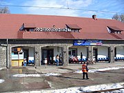 Train station


.jpg)
.jpg)


| International | |
|---|---|
| National | |