
Glenbeulah, Wisconsin
Glenbeulah, Wisconsin | ||
|---|---|---|
FIPS code 55-29350[5] | | |
| GNIS feature ID | 1565565[2] | |
| State Highways | ||
| Rustic Roads | ||
| Website | glenbeulahwi | |
Glenbeulah is a village in
History
A post office called Glenbeulah has been in operation since 1860.[6] Glenbeulah was named from its setting in a glen, and in honor of Beulah, the mother of a railroad contractor.[7]
Geography
Glenbeulah is located at 43°47′48″N 88°2′45″W / 43.79667°N 88.04583°W (43.796630, -88.045834).[8]
According to the United States Census Bureau, the village has a total area of 0.71 square miles (1.84 km2), of which, 0.68 square miles (1.76 km2) of it is land and 0.03 square miles (0.08 km2) is water.[9]
Demographics
| Census | Pop. | Note | %± |
|---|---|---|---|
| 1880 | 375 | — | |
| 1920 | 298 | — | |
| 1930 | 284 | −4.7% | |
| 1940 | 357 | 25.7% | |
| 1950 | 384 | 7.6% | |
| 1960 | 428 | 11.5% | |
| 1970 | 496 | 15.9% | |
| 1980 | 423 | −14.7% | |
| 1990 | 386 | −8.7% | |
| 2000 | 378 | −2.1% | |
| 2010 | 463 | 22.5% | |
| 2019 (est.) | 464 | [4] | 0.2% |
| U.S. Decennial Census[10] | |||
2010 census
As of the
There were 194 households, of which 32.0% had children under the age of 18 living with them, 55.7% were married couples living together, 7.2% had a female householder with no husband present, 6.2% had a male householder with no wife present, and 30.9% were non-families. 22.2% of all households were made up of individuals, and 9.7% had someone living alone who was 65 years of age or older. The average household size was 2.39 and the average family size was 2.81.
The median age in the village was 41.4 years. 22% of residents were under the age of 18; 5% were between the ages of 18 and 24; 27.8% were from 25 to 44; 33.1% were from 45 to 64; and 12.1% were 65 years of age or older. The gender makeup of the village was 50.8% male and 49.2% female.
2000 census
As of the
There were 153 households, out of which 33.3% had children under the age of 18 living with them, 61.4% were married couples living together, 6.5% had a female householder with no husband present, and 29.4% were non-families. 22.9% of all households were made up of individuals, and 7.8% had someone living alone who was 65 years of age or older. The average household size was 2.47 and the average family size was 2.97.
In the village, the population was spread out, with 24.1% under the age of 18, 7.1% from 18 to 24, 33.6% from 25 to 44, 22.8% from 45 to 64, and 12.4% who were 65 years of age or older. The median age was 37 years. For every 100 females, there were 103.2 males. For every 100 females age 18 and over, there were 99.3 males.
The median income for a household in the village was $42,656, and the median income for a family was $47,045. Males had a median income of $32,411 versus $20,568 for females. The
Notable people
- Thomas Armstrong, Wisconsin State Representative
- Emery Crosby, Wisconsin State Representative
- Glenn Grothman, United States House of Representatives[11]
- Edwin Slade, Wisconsin State Assembly[12]
- William Van Pelt, United States House of Representatives
Images
-
 Post office
 -
 Looking west at the sign for Glenbeulah
 -
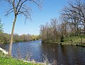 Looking east at the Mullet River in Glenbeulah
 -
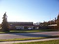 Elkhart Lake/Glenbeulah High School
 -
 Village welcome sign


See also
References
- ^ "2019 U.S. Gazetteer Files". United States Census Bureau. Retrieved August 7, 2020.
- ^ a b "US Board on Geographic Names". United States Geological Survey. October 25, 2007. Retrieved January 31, 2008.
- ^ a b "U.S. Census website". United States Census Bureau. Retrieved November 18, 2012.
- ^ a b "Population and Housing Unit Estimates". United States Census Bureau. May 24, 2020. Retrieved May 27, 2020.
- ^ a b "U.S. Census website". United States Census Bureau. Retrieved January 31, 2008.
- ^ "Sheboygan County". Jim Forte Postal History. Retrieved March 18, 2015.
- ^ Chicago and North Western Railway Company (1908). A History of the Origin of the Place Names Connected with the Chicago & North Western and Chicago, St. Paul, Minneapolis & Omaha Railways. p. 77.
- ^ "US Gazetteer files: 2010, 2000, and 1990". United States Census Bureau. February 12, 2011. Retrieved April 23, 2011.
- ^ "US Gazetteer files 2010". United States Census Bureau. Archived from the original on January 12, 2012. Retrieved November 18, 2012.
- ^ "Census of Population and Housing". Census.gov. Retrieved June 4, 2015.
- ^ "Biography". Congressman Glenn Grothman. Retrieved October 21, 2015.
- ^ 'The Legislative Manual of the State of Wisconsin 1870, pg. 236
External links
 | ||||
Villages | ||||
Towns | ||||
| CDPs | ||||
| Other communities |
| |||
| Former communities |
| |||
| Footnotes | ‡This populated place also has portions in an adjacent county or counties | |||
| ||||
| International | |
|---|---|
| National | |