
Gulbene Municipality
Gulbene Municipality
Gulbenes novads | |
|---|---|
 Flag  Coat of arms | |
 | |
| Country | |
| Formed | 2009 |
| Centre | Gulbene |
| Government | |
| • Council Chair | Andis Caunītis (LRA) |
| Area | |
| • Total | 1,872.22 km2 (722.87 sq mi) |
| • Land | 1,827.33 km2 (705.54 sq mi) |
| • Water | 44.89 km2 (17.33 sq mi) |
| Population (2024)[2] | |
| • Total | 18,740 |
| • Density | 10/km2 (26/sq mi) |
| Website | www |
Gulbene Municipality (
Tirza parish and Gulbene town the administrative centre being Gulbene. The population in 2020 was 19,771.[3]
Images
-
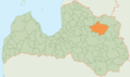 Boundaries of the municipality from 2009 to 2021
 -
 Gulbene
 -
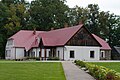
 Stāmeriena
 -
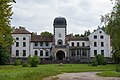
 Litene
 -
 Jaungulbene


See also
- Administrative divisions of Latvia (2009)
References
- ^ "Reģionu, novadu, pilsētu un pagastu kopējā un sauszemes platība gada sākumā". Central Statistical Bureau of Latvia. Retrieved 18 January 2023.
- ^ "Iedzīvotāju skaits pēc tautības reģionos, pilsētās, novados, pagastos, apkaimēs un blīvi apdzīvotās teritorijās gada sākumā (pēc administratīvi teritoriālās reformas 2021. gadā)". Central Statistical Bureau of Latvia. Retrieved 19 June 2024.
- ^ "ISG020. Population number and its change by statistical region, city, town, 21 development centres and county". Central Statistical Bureau of Latvia. 2020-01-01. Retrieved 2021-02-12.
| National | |
|---|---|
| Geographic | |
57°10′55″N 26°45′50″E / 57.18194°N 26.76389°E
This Vidzeme location article is a stub. You can help Wikipedia by expanding it. |