
Jēkabpils
This article needs additional citations for verification. (April 2012) |
Jēkabpils
Jakubów (Polish) Jakobstadt | |
|---|---|
State city | |
 | |
|
UTC+3 (EEST) | |
| Postal code | LV-52(01/02) |
| Calling code | (+371) 652 |
| Website | www |
Jēkabpils (Latvian: . The two cities were united during the Soviet rule in 1962 under the Jēkabpils name, but retain their distinct regional character.
Jēkabpils was also formerly home to the Soviet Jēkabpils Air Base.
History
.jpg)
A stone cross-castle –
During the 17th century, persecuted Old Believers from Russia settled along the Daugava river. In 1670 this settlement, gradually growing around the Sala Inn, became known as Jēkabpils (Jakobstadt in German) in honor of the Duke of Courland, Jacob Kettler, who granted Magdeburg rights to the town.
A local legend about the town's origin states that the duke was hunting one day but became lost. At the Daugava River, he simultaneously spotted a lynx underneath a fir tree as well as a town at the same time. This image of the lynx underneath a fir tree is the town's coat of arms.
In the period of the Duchy of Courland the residents of the town were mostly Russian Old believers,
In 1704, during the
After the war and an epidemic of plague, the town again prospered.

In 1764 the first ferry crossing to Krustpils was opened in the town. During the reign of Peter von Biron a small community of German-speaking craftsmen developed in the town besides Russians and Poles. Jews, however, were prohibited from entering the town. In 1795 Jacobstadt, like the whole Duchy of Courland and Semigallia, was incorporated into the Russian Empire.
In 1826 Friedrich Georg Wilhelm von Struve made his geodesic measurements near the town.
In 1834 the first hospital was opened in the town. During this period a theater and library were also opened, and the first streets were cobbled.
In 1861 with the opening of the Riga–Daugavpils railway through Krustpils the role of the Daugava and barges as a main means of transport decreased. However, the river was still used for timber rafting.

At the turn of the 20th century there were a bank, an insurance company, a match factory, a
In 1919 Jēkabpils became the administrative centre of the newly established Jaunjelgava district. In 1932 a sugar refinery was built in the town. In 1936 a bridge was built over the Daugava. In this way Jēkabpils and Krustpils were united for the first time. During the
Jēkabpils and Krustpils were merged in 1962 under the name Jēkabpils. During the
From 2009 to 2021, the city, while being a separate first-level municipality (republican city, republikas pilsēta), was also the extraterritorial center of Jēkabpils Municipality. Since 2021, it retains state city status, but does not have a separate first-level local government.
Geography
The population of Jēkabpils town is 29,100. The two historical parts of Jēkabpils — Krustpils and historic Jēkabpils — are connected by the bridge across the
Climate
Jēkabpils has a humid continental climate (Köppen Dfb).
| Climate data for Jēkabpils (Zīlāni, 1991-2020 normals, extremes 1943–present) | |||||||||||||
|---|---|---|---|---|---|---|---|---|---|---|---|---|---|
| Month | Jan | Feb | Mar | Apr | May | Jun | Jul | Aug | Sep | Oct | Nov | Dec | Year |
| Record high °C (°F) | 10.0 (50.0) |
11.8 (53.2) |
18.0 (64.4) |
26.3 (79.3) |
30.0 (86.0) |
32.3 (90.1) |
34.7 (94.5) |
34.3 (93.7) |
30.5 (86.9) |
22.6 (72.7) |
16.6 (61.9) |
10.3 (50.5) |
34.7 (94.5) |
| Mean daily maximum °C (°F) | −1.8 (28.8) |
−1.2 (29.8) |
3.8 (38.8) |
11.8 (53.2) |
17.7 (63.9) |
21.1 (70.0) |
23.6 (74.5) |
22.4 (72.3) |
16.7 (62.1) |
9.6 (49.3) |
3.3 (37.9) |
−0.4 (31.3) |
10.5 (51.0) |
| Daily mean °C (°F) | −4.0 (24.8) |
−4.0 (24.8) |
−0.1 (31.8) |
6.6 (43.9) |
12.1 (53.8) |
15.7 (60.3) |
18.1 (64.6) |
16.9 (62.4) |
11.9 (53.4) |
6.1 (43.0) |
1.4 (34.5) |
−2.1 (28.2) |
6.6 (43.8) |
| Mean daily minimum °C (°F) | −6.5 (20.3) |
−7.1 (19.2) |
−3.9 (25.0) |
1.6 (34.9) |
6.1 (43.0) |
10.1 (50.2) |
12.7 (54.9) |
11.7 (53.1) |
7.6 (45.7) |
3.1 (37.6) |
−0.9 (30.4) |
−4.4 (24.1) |
2.5 (36.5) |
| Record low °C (°F) | −35.4 (−31.7) |
−36.7 (−34.1) |
−24.6 (−12.3) |
−14.4 (6.1) |
−4.6 (23.7) |
−0.4 (31.3) |
4.1 (39.4) |
0.3 (32.5) |
−4.2 (24.4) |
−10.9 (12.4) |
−22.0 (−7.6) |
−35.2 (−31.4) |
−36.7 (−34.1) |
| Average precipitation mm (inches) | 47.8 (1.88) |
40.4 (1.59) |
37.2 (1.46) |
37.0 (1.46) |
59.6 (2.35) |
75.0 (2.95) |
71.0 (2.80) |
74.5 (2.93) |
56.0 (2.20) |
69.4 (2.73) |
54.7 (2.15) |
47.5 (1.87) |
670.1 (26.37) |
| Average precipitation days (≥ 1 mm) | 12 | 10 | 9 | 8 | 9 | 10 | 11 | 11 | 9 | 11 | 11 | 12 | 123 |
| Average relative humidity (%)
|
87.9 | 85.6 | 77.3 | 68.5 | 68.0 | 72.6 | 74.6 | 77.0 | 82.0 | 86.4 | 89.5 | 89.4 | 79.9 |
| Source 1: LVĢMC[4][5] | |||||||||||||
| Source 2: NOAA (precipitation days, humidity 1991-2020)[6] | |||||||||||||
Demographics
As of 1 January 2017, the city had a population of 23,750.
Sights
Jēkabpils
In the older parts of the city, some buildings have been preserved. The castle of
Jēkabpils District
One of the Struve Geodetic Arc original station points is located in Strūves park. In Tadenava, not far from Jēkabpils itself, there is a memorial museum to the great Latvian poet Rainis. Nearby are also the castle of Justine and Dignāja. The highest point of Selonia — Ormaņkalns is in the vicinity of Klauce. Between Nereta and Aknīste there is a museum "Riekstiņi" commemorating the famous Latvian writer Jānis Jaunsudrabiņš.
Notable people
- Uga Skulme (1895-1963), painter
- Elita Kļaviņa (born 1966), actress
- Juris Umbraško (born 1978), basketball coach
- Arvis Viguls (born 1987), poet, translator
- Deniss Rakels (born 1992), footballer
- Reinis Nitišs (born 1995), World Rallycross driver
Twin towns – sister cities
 Czerwionka-Leszczyny, Poland
 Lida, Belarus
 Maardu, Estonia
 Melle, Germany
 Myrhorod, Ukraine
 Qaraçuxur, Azerbaijan
 Rokiškis, Lithuania
- Sokołów Podlaski, Poland
Gallery
-
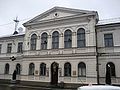 Jēkabpils city council
 -
 Old believers church in Jēkabpils
 -
 Bell tower of the orthodox Holy Spirit Monastery.
 -
 Jēkabpils central square
 -
 Krustpils railway station in Jēkabpils
 -
 Pļaviņu iela (street) and Daugava River levee
 -
 Typical 19th century red brick building in the centre of former Krustpils.
 -
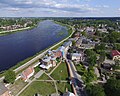 Areal view of the historic centre of Jēkabpils and orthodox Holy Spirit monastery.
 -
 St. Michail lutheran church in Jēkabpils.


..JPG)


.jpg)
.jpg)
References
- ^ "Reģionu, novadu, pilsētu un pagastu kopējā un sauszemes platība gada sākumā". Central Statistical Bureau of Latvia. Retrieved 18 January 2023.
- ^ "Iedzīvotāju skaits pēc tautības reģionos, pilsētās, novados, pagastos, apkaimēs un blīvi apdzīvotās teritorijās gada sākumā (pēc administratīvi teritoriālās reformas 2021. gadā)". Central Statistical Bureau of Latvia. Retrieved 19 June 2024.
- ^ "Gross domestic product and gross value added by planning region, State city and municipality at current prices (after administrative-territorial reform in 2021)". stat.gov.lv.
- ^ "Klimatisko normu dati". Latvian Environment, Geology and Meteorology Centre. Retrieved March 21, 2023.
- ^ "Gaisa temperatūras rekordi". Latvian Environment, Geology and Meteorology Centre. Retrieved March 21, 2023.
- ^ "World Meteorological Organization Climate Normals for 1981-2010". National Oceanic and Atmospheric Administration. Retrieved March 31, 2023.
- ^ [1][permanent dead link]
- ^ "Starptautiskā sadarbība". jekabspils.lv (in Latvian). Jēkabpils. Retrieved 2019-08-31.
| International | |
|---|---|
| National | |
| Geographic | |