
Haar, Bavaria
Haar | |
|---|---|
 Town hall | |
 Coat of arms | |
Location of Haar within Munich district 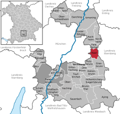 | |
Oberbayern | |
| District | Munich |
| Government | |
| • Mayor (2020–26) | Andreas Bukowski[1] (CSU) |
| Area | |
| • Total | 12.90 km2 (4.98 sq mi) |
| Elevation | 542 m (1,778 ft) |
| Population (2022-12-31)[2] | |
| • Total | 22,555 |
| • Density | 1,700/km2 (4,500/sq mi) |
| Time zone | UTC+01:00 (CET) |
| • Summer (DST) | UTC+02:00 (CEST) |
| Postal codes | 85540 |
| Dialling codes | 089 |
| Vehicle registration | M |
| Website | www.gemeinde-haar.de |
Haar (German pronunciation: [ˈhaːɐ̯]) is a municipality in the district of Munich, in Bavaria, Germany. It is 12 km east of Munich (centre). As of 2017 it had a population of more than 20,000.
It is home to the
References
- Bayerisches Landesamt für Statistik, 15 July 2021.
- ^ Genesis Online-Datenbank des Bayerischen Landesamtes für Statistik Tabelle 12411-003r Fortschreibung des Bevölkerungsstandes: Gemeinden, Stichtag (Einwohnerzahlen auf Grundlage des Zensus 2011) (Hilfe dazu).
- ^ "New location for the Boards of Appeal". European Patent Office. 2017. Retrieved 1 August 2017.
- ^ "Boards of Appeal starting work at their new location". European Patent Office. 2 October 2017. Retrieved 6 October 2017.
| International | |
|---|---|
| National | |
| Geographic | |
This Munich district location article is a stub. You can help Wikipedia by expanding it. |