
Harich, Armenia
40°35′53″N 44°00′27″E / 40.59806°N 44.00750°E
Harich
Հառիճ | |
|---|---|
UTC+5 |
Harich (
Artik Municipality of the Shirak Province of Armenia. Within the village is the Harichavank Monastery
of the 8th century. Across the gorge from the monastery is a 3rd millennium BC fortress and tomb field.
Demographics
| Year | Pop. | ±% p.a. | ||
|---|---|---|---|---|
| 1831 | 86 | — | ||
| 1887 | 654 | +3.69% | ||
| 1926 | 880 | +0.76% | ||
| 1939 | 1,035 | +1.26% | ||
| 1959 | 1,958 | +3.24% | ||
| 1970 | 1,096 | −5.14% | ||
| 1979 | 1,058 | −0.39% | ||
| 2001 | 1,123 | +0.27% | ||
| 2004 | 1,427 | +8.31% | ||
| ||||
| Source: [1] | ||||
Gallery
-
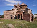 Rear view of 7th century Harichavank Monastery
 -
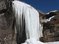 Frozen waterfalls
 -
 Field in Harich


References
- ^ Հայաստանի Հանրապետության բնակավայրերի բառարան [Republic of Armenia settlements dictionary] (PDF) (in Armenian). Yerevan: Cadastre Committee of the Republic of Armenia. 2008. Archived from the original (PDF) on 11 March 2018.
- Harich, Armenia at GEOnet Names Server
- World Gazeteer: Armenia[dead link] – World-Gazetteer.com
- Report of the results of the 2001 Armenian Census, Statistical Committee of Armenia
- Kiesling, Brady (2005), Rediscovering Armenia: Guide, Yerevan, Armenia: Matit Graphic Design Studio
- Kiesling, Brady (June 2000). Rediscovering Armenia: An Archaeological/Touristic Gazetteer and Map Set for the Historical Monuments of Armenia (PDF). Archived (PDF) from the original on 6 November 2021.
Capital: Gyumri | |||
| Urban settlements | Akhuryan Municipality | ||
Amasia Municipality | |||
Ani Municipality | |||
Artik Municipality | |||
Ashotsk Municipality | |||
| International | |
|---|---|
| National | |
This article about a location in Shirak Province, Armenia is a stub. You can help Wikipedia by expanding it. |