
High Street (Perth, Scotland)
Perth, Perth and Kinross, Scotland | |
| East end | Tay Street (A989) |
|---|---|
| West end | Caledonian Road (A989) |
High Street is a street and the primary retail area of the Scottish city of
Layout
High Street, as a whole, is one of the three major east–west running streets in the city centre, the others being Mill Street to the north and South Street to the south,[1] although Mill Street was a later addition.[2] The River Tay runs perpendicular to the eastern end of the street,[3] at Tay Street, where more Victorian-era buildings now stand, as well a stone tablet indicating the site of a bridge that was destroyed in 1621.[4]
There is an entrance to
High Street
Beginning at Tay Street and continuing west to South Methven Street.
In a 1980 photograph by W. H. Findlay, a view of 80–94 High Street (part of a Category B listed row)[6] shows the Wallaces department store. It was demolished two years later.[7]
Old High Street
Established in 1897, Alexander Thomson & Sons Grocers and Wine Merchants was a popular vendor on the street.[9] Thomas' son, Peter, later established Peter Thomson (Perth) Limited further along the street.
The Old High Street exemplifies how comparatively narrow the medieval street was.
Junctions
- From east to west
- St John Street (south)
- Skinnergate (north)
- Kirkgate (south)
- King Edward Street (south)
- Kinnoull Street (north)
- Scott Street (south)
- South Methven Street (crosses)
- St Paul's Square (south)
- New Row (south)
- Milne Street (south)
- Paul Street (north)
- Lickey Street (south)
Vennels
Below is a list of the vennels that connect to the High Street.
- Cow Vennel[10][11] (Mill Street to High Street) (Canal Street to South Street) – so named because it is where people would drive their cattle onto the South Inch for grazing[12]
- Cutlog Vennel[13] (Mill Street to High Street)
- Guard Vennel (Mill Street to High Street)
- Meal Vennel[14] (South Street to High Street)
Archaeology
Between 1975 and 1977, an archaeological excavation was undertaken at 75–95 High Street. The project "highlighted the preservative qualities of the
Gallery
-
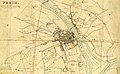 This 1832 map of Perth, by James Gardner, shows the street, then a uniform "High Street"
 -
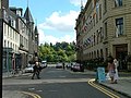 Looking east to Tay Street
 -
 And west, towards the modern section, from Tay Street
 -
 St Paul's Church
 -
 Looking east


.jpg)
See also
References
- ^ Perth High Street – Landscapes, BBC
- ^ a b Perth: The Archaeology and Development of a Scottish burgh – David P. Bowler, Tayside and Fife Archaeological Committee (2004), p. 23
- ^ Ordnance Gazetteer of Scotland: A Graphic and Accurate Description of Every Place in Scotland, Francis Hindes Groome (1901)
- ^ Civic History of Perth from Medieval Times – Perth Civic Trust
- ^ St John's Shopping Centre – Ordnance Gazetteer of Scotland: A Graphic and Accurate Description of Every Place in Scotland, Francis Hindes Groome (1901)
- ^ "HIGH STREET 86-96 (S SIDE) (EVEN NUMBERS) (LB39479)". portal.historicenvironment.scot. Retrieved 16 December 2022.
- ^ "Perth & Kinross Archives". Twitter. Retrieved 16 December 2022.
- ^ "SOUTH METHVEN STREET, HIGH STREET AND ST PAUL'S SQUARE, ST PAUL'S CHURCH". portal.historicenvironment.scot. Retrieved 8 October 2021.
- ^ Leslie's directory for Perth and Kinross (1911)
- ^ "Perth projects its medieval past with VR" – The Sunday Times, 7 July, 2017
- ^ Cow Vennel – Google Street View, October 2015
- ^ Medieval Walk – Perth & Kinross Museums & Galleries
- ^ Cutlog Vennel – Google Maps
- ^ "Highland Communities in Dundee and Perth 1787-1891" – Abertay University, p. 48
- ^ 1.5 The History of research – Scottish Archaeological Research Framework