
South Street (Perth, Scotland)
Perth, Perth and Kinross, Scotland | |
| East end | Dundee Road (A85) |
|---|---|
| West end | County Place (A93) |
South Street is a prominent street in the Scottish city of
Perth developed from an initial plan of two parallel streets: South Street and High Street — about 500 feet (150 m)[1] to the north — in the 15th century,[3] linked by several vennels leading north and south. Mill Street, to the north of High Street, followed shortly thereafter. South Street was originally terminated at its eastern end by Gowrie House (site of today's Perth Sheriff Court), which had an arched entrance from South Street.[4] Upon its demolition in the early 19th century, direct access was granted to the Tay.[5]
Perth's original William Low supermarket was on South Street. It later moved to Victoria Street, prior to a second location opening on the Crieff Road.
Notable locations on South Street
- From east to west
- Queen's Bridge
- 1–3 South Street
- Salutation Hotel
Junctions
- From east to west
- Watergate (north)
- Speygate (south)
- St John Street (north)
- Princes Street (south)
- King Edward Street (north)
- Scott Street (crosses)
- South Methven (north)
- King Street (south)
Vennels
The below vennels begin or end on South Street.
- Cow Vennel[6][7][8] (Canal Street to South Street) – so named because it is where people would drive their cattle onto the South Inch for grazing[9]
- Fleshers' Vennel[7][6][10] (St John's Place to 49 South Street)
- Horners Lane[11] (South Street to Canal Street)
- Meal Vennel[12][13][14] (South Street to 164 High Street). Described in 1907 as "an old thoroughfare, presently the resort of curio dealers, and the happy hunting-ground of collectors".[15] Several labourers lived on the street in 1911.[16]
- RopemakersClose (South Street to Canal Street)
- Weaver Vennel[17] (from and to South Street)
Gallery
-
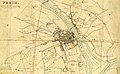 This 1832 map of Perth, by James Gardner, shows South Street as one of the three main streets in Perth at the time
 -
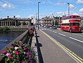 South Street crossing Queen's Bridge, with Perth Sheriff Court, the former site of the Gowrie House, in view on the left. 1–3 South Street is on the right
 -
 At South Methven Street, looking east to Kinnoull


References
- ^ a b Ordnance Gazetteer of Scotland: A Graphic and Accurate Description of Every Place in Scotland, Francis Hindes Groome (1901)
- ^ "Perth City | Perth, Live Life Well | Explore Perthshire". www.perthcity.co.uk. Archived from the original on 16 October 2007.
- ^ Perth High Street – Landscapes, BBC
- ^ Perth, the Ancient Capital of Scotland: The Story of Perth from the Invasion of Agricola to the Passing of the Reform Bill in 2 volumes – Samuel Cowan J.P. (1904), chapter 3
- ISBN 9781398101425
- ^ a b "Perth projects its medieval past with VR" – The Sunday Times, 7 July, 2017
- ^ a b Streets, Lanes, Entries, &c. – Leslie's directory for Perth and Kinross (1911), p. 12
- ^ Cow Vennel – Google Street View, October 2015
- ^ Medieval Walk – Perth & Kinross Museums & Galleries
- ^ Fleshers' Vennel – Google Maps
- ^ Horners Lane – Google Maps
- ^ "Highland Communities in Dundee and Perth 1787-1891" – Abertay University, p. 48
- ^ Official Guide to Perth and Its Neighbourhood by the Tramway Car Routes – Perth Town Council (1907), p. 8
- ^ Leslie's directory for Perth and Kinross (1911), p. 13
- ^ Official Guide to Perth and Its Neighbourhood by the Tramway Car Routes – Perth Town Council (1907), p. 10
- ^ Leslie's directory for Perth and Kinross (1911)
- ^ Civic History of Perth from Medieval Times – Perth Civic Trust