
Hillman Peak
| Hillman Peak | |
|---|---|
 Southeast aspect | |
| Highest point | |
| Elevation | 8,151 ft (2,484 m)[1] |
| Prominence | 1,391 ft (424 m)[1] |
| Parent peak | Mount Scott (8,934 ft)[2] |
| Isolation | 8.01 mi (12.89 km)[2] |
| Coordinates | 42°57′07″N 122°10′09″W / 42.9518305°N 122.1692692°W[3] |
| Naming | |
| Etymology | John Wesley Hillman |
| Geography | |
 Hillman Peak Location in Oregon  Hillman Peak Hillman Peak (the United States) | |
| Country | class 3 scrambling[2] |
Hillman Peak is an 8,151 feet (2,484 m)
History
Hillman Peak was named by William Gladstone Steel for John Wesley Hillman (1832–1915), a prospector who discovered Crater Lake on June 12, 1853.[3] The peak's "Hillman Peak" toponym was officially adopted in 1928 by the United States Board on Geographic Names.[3] Variant names prior to 1928 included Glacier Peak and Maxwell Peak.
Climate
Based on the
Geology
Hillman Peak was created when Mount Mazama, a large stratovolcano erupted violently approximately 7,700 years ago and formed on the caldera rim. The peak is the remnant of a parasitic cone on the western flank of Mount Mazama, such that when the caldera formed, the eastern half of the Hillman cone disappeared. The peak is composed of lava flows containing pyroxene and hornblende andesites and breccias.[4] Evidence suggests that the pre-eruption Hillman cone acted as a cleaver which was never entirely covered by glacial ice.[8]
According to the Global Volcanism Program (GVP), Hillman Peak is classified as a subfeature stratovolcano of Mount Mazama.
See also
Gallery
-

-
-

-
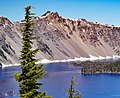
 Hillman Peak (center) and The Watchman (left)


References
- ^ a b "Hillman Peak, Oregon". Peakbagger.com. Retrieved 2023-01-28.
- ^ a b c "Hillman Peak - 8,151' OR". listsofjohn.com. Retrieved 2023-01-28.
- ^ a b c d "Hillman Peak". Geographic Names Information System. United States Geological Survey, United States Department of the Interior. Retrieved 2023-01-28.
- ^ a b "The Hillman Cone, Craterlakeinstitute.com". Retrieved 2023-01-28.
- ISSN 1027-5606.
- ^ Crater Lake Climate, National Park Service, Retrieved 2023-01-23.
- ^ "Facts and Figures", National Park Service, United States Department of Interior, Crater Lake, Oregon, November 2001.
- ISBN 9780787299705, p. 536.
External links
- National Geodetic Survey Data Sheet
- Crater Lake National Park (National Park Service)
- Weather forecast: Hillman Peak