
Hindpool
| Hindpool | ||
|---|---|---|
Shire county | ||
| Region | ||
| Country | England | |
| Sovereign state | United Kingdom | |
| Post town | BARROW-IN-FURNESS | |
| Postcode district | LA | |
| Dialling code | 01229 | |
| Police | Cumbria | |
| Fire | Cumbria | |
| Ambulance | North West | |
| UK Parliament | ||
Hindpool is an area and
The ward itself will be combined with Barrow Island and Central wards in April 2023 following formation of the new Westmorland and Furness Local Authority and be named 'Old Barrow'.
History
The Hindpool Estate appears on an 1843 Ordnance Survey map of what was then the village of Barrow within the parish of Dalton-in-Furness. Hindpool was at the forefront of Barrow's growth during the late 19th and early 20th century with numerous industries located within the area, most notably the Iron and Steelworks.
Architecture
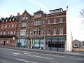
Barrow being a planned town has many fine buildings to show for it, Abbey Road in particular is lined by numerous listed buildings including the Barrow Main Public Library, the Duke of Edinburgh Hotel, Nan Tait Centre and Ramsden Hall.[3] Almost all residential buildings in Hindpool are terraced housing, the population density of the area was 29.86 people per hectare in 2001 (three times Barrow average and eight times national population density average).[4]
-
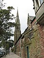
 St. James' Church (Grade II*)
 -
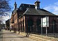
 Barrow Main Public Library (Grade II)
 -
 Duke of Edinburgh Hotel (Grade II)
 -
 Nan Tait Centre (Grade II)
 -
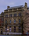 National Westminster Bank (Grade II)
 -
 Ramsden Hall (Grade II)
 -
 St. Mary of Furness Roman Catholic Church(Grade II)
 -
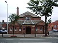
 Abbey Road Working Men's Club (Grade II)
 -
 Victoria Hall (Grade II)
 -
 Cookes Building and Oxford Chambers (Grade II)


Demographics
| Vital statistics [5] | Hindpool | Barrow-in-Furness | England |
|---|---|---|---|
| Religious individuals | 76.95% | 81.61% | 77.71% |
| Non-religious individuals | 14.29% | 10.79% | 14.59% |
| Religion withheld | 8.76% | 7.59% | 7.69% |
| Individuals in fairly good to good health |
83.48% | 86.75% | 90.97% |
| Individuals in bad health | 16.52% | 13.25% | 9.03% |
| People aged 16–74 who are economically active |
56.53% | 60.84% | 66.87% |
| People aged 16–74 who aren't economically active |
43.47% | 39.16% | 33.13% |
| People aged 16–74 with no qualifications |
39.71% | 32.82% | 28.85% |
Retail sector
The vast majority of Barrow's
Transportation
Hindpool has a well established road network which includes the
See also
References
- ^ "Maps and details of Barrow's Electoral Boundaries". Barrow Borough Council. Archived from the original on 10 March 2007. Retrieved 22 January 2011.
- ^ "Ward population 2011". Retrieved 13 June 2015.
- ^ "Listed Buildings Online Search Form". English Heritage. Archived from the original on 4 January 2015. Retrieved 12 December 2014.
- ^ "Hindpool Ward Population Density". Office for National Statistics. Retrieved 22 January 2011.
- ^ "Hindpool: Key Figures for 2001 Census". Office for National Statistics. Retrieved 22 January 2011.