
Hurd Peak
| Hurd Peak | |
|---|---|
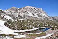
 North aspect, from South Lake | |
| Highest point | |
| Elevation | 12,237 ft (3,730 m) NAVD 88[1] |
| Prominence | 477 ft (145 m)[1] |
| Parent peak | Mount Goode (13,085 ft)[2] |
| Isolation | 1.23 mi (1.98 km)[2] |
| Coordinates | 37°08′27″N 118°33′58″W / 37.1408984°N 118.5660725°W[3] |
| Naming | |
| Etymology | H.C. Hurd[4] |
| Geography | |
 Hurd Peak Location in California  Hurd Peak Hurd Peak (the United States) | |
| Location | class 3[4] |
Hurd Peak is a 12,237-foot-elevation (3,730-meter) mountain summit located one mile east of the crest of the
Topographic relief
is significant as the north aspect rises nearly 2,500 feet (760 meters) above South Lake in approximately one mile.
Etymology
This mountain's toponym was officially adopted in 1920 by the
U.S. Board on Geographic Names based on a recommendation by the Sierra Club.[3] It honors the memory of Hurd Clarence Hurd (April 16, 1870 – July 8, 1914), who made the first ascent in 1906 while connected with development work in the vicinity.[5] H. C. Hurd was a civil engineer who received his degree from Princeton University in 1893. He was elected as a member of the American Society of Civil Engineers in 1913, but the following year met an untimely death by accidental drowning in Chesapeake Bay.[6]
Climbing
Established climbing routes on Hurd Peak:[7]
- West Face via Treasure Lakes – class 3
- East Face – class 3
- South Ridge – class 4
- Northeast Arete – class 5.5
- North Ridge – class 5.7
Climate
According to the
snowfall onto the range (orographic lift). Precipitation runoff from this mountain drains into the South Fork of Bishop Creek
.
Gallery
-
 Southeast aspect
 -
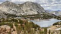
 Southeast aspect, with Spearhead Lake and Long Lake
 -
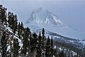
 Hurd Peak (left) from South Lake
 -
 North aspect, with Mt. Goode to left
 -
 Northwest aspect, from Lake 10668 of Treasure Lakes
 -
 Southeast aspect, with Saddlerock Lake
 -


References
- ^ a b "Hurd Peak, California". Peakbagger.com. Retrieved 2021-04-21.
- ^ a b "Hurd Peak". ListsOfJohn.com. Retrieved 2021-04-21.
- ^ a b c "Hurd Peak". Geographic Names Information System. United States Geological Survey, United States Department of the Interior. Retrieved 2021-04-21.
- ^ ISBN 978-0898863130.
- ^ Alan M. Hedden and David R. Brower, A Climber's Guide to the High Sierra (1954)
- ^ Transactions of the American Society of Civil Engineers, 1915, page 1433.
- ^ Hurd Peak, Mountainproject.com
- ISSN 1027-5606.
External links
- Weather forecast: Hurd Peak
- Hurd Peak Rock Climbing: Mountainproject.com
Places adjacent to Hurd Peak | ||||||||||||||||
|---|---|---|---|---|---|---|---|---|---|---|---|---|---|---|---|---|
| ||||||||||||||||