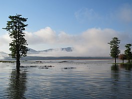
Ira Lalaro
| Lake Ira Lalaro | |
|---|---|
 Lake Ira Lalaro | |
| Coordinates | 8°27′0″S 127°8′0″E / 8.45000°S 127.13333°E |
| Primary outflows | Irasiquero River |
| Basin countries | East Timor |
| Max. length | 6.5 km (4.0 mi) |
| Max. width | 3 km (1.9 mi) |
| Surface area | Average 1.9 km2 (0.73 sq mi) |
| Surface elevation | 318 m (1,043 ft) |
| Settlements | Mehara, Malahara, Poros, Muapitine |
Lake Ira Lalaro (also Iralalaro, Ira-Lalaro, Surubec, Suro Bec) is a
Geography and geology

Ira Lalaro is in the far east of Timor island, and is part of the Nino Konis Santana National Park (680 square kilometres (260 sq mi), which was established in August 2007 by East Timor.[6][7]
The lake is located in a basin bounded by the Paitchau Mountains, within the Lospalos plateau. The region has karstic formations of limestone, with dolines, blind valleys, caves and springs. Ira Lalaro has an average water spread area of 1,900 hectares (4,700 acres), which varies from 1,000–5,500 hectares (2,500–13,600 acres). It is in a high plateau depression at an elevation of 334 metres (1,096 ft) "formed by a huge polje karst formation". The lake flows to the east and as the lake water recedes during the dry season the land exposed becomes a pasture or scrubby grassland.[8]
The lake basin is surrounded by tropical dry forest which is of biodiversity value. The Irasiquero River, which originates from Lake Ira Lalaru, disappears in the main sink hole, the Mainina, about 3.5 kilometres (2.2 mi) downstream of the lake outlet, and does not re-appear; tracer studies indicate that the underground route of water flow leads to the coast. There are human settlements in the area.[5]
Biodiversity

The biodiversity of the lake's aquatic system, including the Irasiquero River, is that of a wetland ecosystem. The forest area is largely undisturbed.[5] In the absence of continuous surface water flow, the invertebrates found in the lake and in the river consist of
The
In a number of field surveys of East Timorese waterbirds and coastal seabirds of carried out in the 2000s, the lake's wetland was identified as one of three wetlands of high national significance in that country, and as being one of the most notable wetlands in Wallacea.[10]: 68
The lake area has both migratory and resident water birds.
References
- ISBN 978-0-85728-389-4.
- ^ Asian Perspectives. University Press of Hawaii. 2005. p. 196. Retrieved 27 July 2013.
- ISBN 978-0-7315-3688-7.
- ^ "TL07 - Important Bird Areas factsheet: Monte Paitchau (proposed Conis Santana National Park)". BirdLife International. Archived from the original on 4 March 2016. Retrieved 27 July 2013.
- ^ a b c d e f g White, Susan; White, Nicholas; Middleton, Greg (2006). "Report of findings on the proposed Iralalaro hydro-electric power scheme, Timor-Leste" (PDF). Timor-Leste Institute for Development Monitoring and Analysis. Retrieved 27 July 2013.
- ^ a b c d "New Subspecies of the Snakeneck Turtle Chelodina mccordi from Timor-Leste (East Timor) (Testudines: Chelidae)". Chelonian Research Foundation. Retrieved 27 July 2013.
- ^ "East Timor". Encyclopedia of the Nations. Retrieved 27 July 2013.)
- ^ "Victor Valley College Tropical Research Initiative Herpetofauna of Timor-Leste Phase I". Markoshea.info. Retrieved 27 July 2013.
- ^ Rhodin, A.G.J.; Walde, A.D.; Horne, B.D.; van Dijk, P.P.; Blanck, T.; Hudson, R. (2011). Turtles in trouble: the world’s 25+ most endangered tortoises and freshwater turtles (PDF). IUCN/SSC Tortoise and Freshwater Turtle Specialist Group, Turtle Conservation Fund, Turtle Survival Alliance, Turtle Conservancy, Chelonian Research Foundation, Conservation International, Wildlife Conservation Society, and San Diego Zoo Global, Lunenburg, Massachusetts, USA. p. 54. Archived from the original (PDF) on 2019-10-29. Retrieved 2014-09-01.
- ^ Trainor, Colin R. (August 2011). "Waterbirds and coastal seabirds of Timor-Leste (East Timor): new site records clarifying residence status, distribution and taxonomy". Forktail. 27: 68–77. Retrieved 14 July 2022.
- ^ "Birds, birding and conservation in Timor-Leste". Scribbid.com. Retrieved 27 July 2013.

