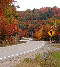
Island Lake, Algoma District
This article includes a improve this article by introducing more precise citations. (May 2023) ) |
Island Lake | |
|---|---|
705|249 |
Island Lake is a rural settlement in the
Island Lake lies on the shores of Upper Island Lake and Lower Island Lake; the Upper Island Lake Dam controls the flow from the former to the latter, and the waters flow via the Root River to the St. Mary's River.
Island Lake—both Upper and Lower, is home to many cottages and private residences; only Lower Island Lake has public beach access and public parking via

Island Lake and surrounding area is regionally famous for spectacular fall colours due to the abundance of forestry and mountains. Telecommunication services in the area are offered by major Canadian company's such as Bell, Rogers, Telus, and other smaller providers; the area has a volunteer fire service and is regularly patrolled by the Ontario Provincial Police.

References
- ^ White, James; Conservation, Canada Commission of (1915). Altitudes in the Dominion of Canada. Mortimer Company, Limited, Printers.
External links
- "Island Lake". Geographical Names Data Base. Natural Resources Canada.
- "Topographic Map sheet 41K9". Atlas of Canada. Natural Resources Canada. 2010-02-04. Archived from the original on 2010-08-03.

