
Sault Ste. Marie, Ontario
Sault Ste. Marie | |
|---|---|
705, and 249[7] | |
| Highways |
|
| Website | saultstemarie |
Sault Ste. Marie (/ˈsuː seɪnt məˈriː/ SOO-saynt-mə-REE) is a city in Ontario, Canada. The third-largest city in Northern Ontario after Sudbury and Thunder Bay, it is located on the St. Mary's River on the Canada–US border. To the southwest, across the river, is the United States and the Michigan city of the same name. The two cities are joined by the Sault Ste. Marie International Bridge, which connects Interstate 75 on the Michigan side to Huron Street on the Ontario side. Shipping traffic in the Great Lakes system bypasses the Saint Mary's Rapids via the American Soo Locks, the world's busiest canal in terms of tonnage that passes through it, while smaller recreational and tour boats use the Canadian Sault Ste. Marie Canal.
The Ojibwe, the indigenous Anishinaabe people of the area, call this area Baawitigong, meaning "place of the rapids." They used this as a regional meeting place during whitefish season in the St. Mary's Rapids (the anglicized form of this name, Bawating, is used in institutional and geographic names in the area). French settlers referred to the rapids on the river as Les Saults de Ste-Marie (the rapids of St. Marie) and the village name was derived from that. The rapids and cascades of the St. Mary's River descend more than 6 m (20 ft) from the level of Lake Superior to the level of the lower lakes. Hundreds of years ago, this slowed shipping traffic, requiring an overland portage of boats and cargo from one lake to the other. The entire name translates to 'Saint Mary's Rapids' or 'Saint Mary's Falls'. The word sault is pronounced [so] in French, and /suː/ in the English pronunciation of the city name.[8] Residents of the city are called Saultites.[9]
Sault Ste. Marie is bordered to the east by the
Native American settlements, mostly of
As the community had developed on both sides of the river, it was considered unified and part of Canada. After the War of 1812 between Great Britain and the United States, the border between Canada and the US was finally settled at the St. Mary's River. At that time, the US prohibited British traders from operating in its territory any longer, causing major losses. The areas separated by the river began to develop as two communities, both named Sault Ste. Marie.[10]
History
Anishinaabe "Time immemorial"–1671
Kingdom of France 1671–1763
British Empire 1763–1867
Canada 1867–present


Early history
After the visit of
In 1668, French
Later, a
The city name originates from Saults de Sainte-Marie, archaic French for "Saint Mary's Falls", a reference to the rapids of Saint Marys River. Etymologically, the word sault comes from an archaic spelling of saut (from sauter), which translates most accurately in this usage to the English word cataract. This in turn derives from the French word for "leap" or "jump" (similar to somersault). Citations dating back to 1600 use the sault spelling to mean a cataract, waterfall or rapids.
In modern French, however, the words chutes or rapides are more usual. Sault survives almost exclusively in geographic names dating from the 17th century. (See also
Traders regularly interacted with tribes from around the Great Lakes. After the English took over former French areas of Canada, their traders became more prominent. Scots-British fur trader John Johnston, his Ojibwe wife, Ozhaguscodaywayquay (Woman of the Green Glade), daughter of a chief, and their multi-racial children were prominent among all societies here in the late eighteenth century. They frequently hosted prominent travelers from both the US and Canada. The children were taught English, Ojibwe and French.
Their daughter,
War of 1812 and aftermath
This fluid environment changed during and after the War of 1812 between Britain and the United States. Trade dropped during the war and on July 20, 1814, an American force destroyed the North West Company depot on the north shore of the St. Marys River. Since the Americans were unable to capture Fort Mackinac, the British forces retained control of Sault Ste. Marie.[12] As noted, after the war and defining a new border, the US closed its territory to British Canadian traders, shutting off much interaction.
.jpg)
In 1870, the United States refused to give the steamer
Canadian Pacific Railway
Although Sault Ste. Marie had been a planned destination for railway expansion since the early 1880s, there was considerable disagreement within the business consortium assembled to build the
A CPR line was surveyed and gradually constructed along the north shore of Lake Huron, cutting through the
Throughout the abrupt rise and fall of these competing projects, CPR construction had slowly marched westward under engineer James Worthington. By 1884, however, changes had occurred in CPR management with the rise of William Cornelius Van Horne, who would later become the company's president. Both Hill and Worthington resigned from the company, and Hill became a bitter opponent of it.[17][18] A new transcontinental mainline through Northern Ontario, passing directly through the interior and bypassing the lakeshore settlements along Lake Huron (including Sault Ste. Marie), was laid out and constructed from a point on the line which became known as Sudbury Junction. This junction point became a small CPR town, and with the discovery of vast mineral resources in the Sudbury Basin during the construction of this transcontinental line north of the junction, mining activity in the Sudbury area grew explosively, leading to the creation of Sudbury District in 1894 and shifting economic focus away from Sault Ste. Marie.
The original CPR line (by then known as the CPR Algoma Branch), which had lain dormant until 1888, was finally reactivated and completed through to Sault Ste. Marie, joining with the
Sault Ste. Marie, Ontario was incorporated as a town in 1888,[citation needed] but its economy stagnated toward the end of the 19th century with the decline of the fur trade.[20]
20th century
The town gained brief international notoriety in 1911 in the trial of
During World War II, and particularly after the US was attacked by Japan at Pearl Harbor in 1941, government concern turned to protection of the locks and shipping channel at Sault Ste. Marie. A substantial military presence was established to protect the locks from a possible attack by Nazi German aircraft from the north. The recent development of long-range bombers increased fears of a sudden air raid. Military strategists studied polar projection maps, which indicated that the air distance from occupied Norway to the town was about the same as the distance from Norway to New York. That direct route of about 5,000 km (3,000 mi) is over terrain where there were few observers and the long winter nights could hide activity.
A joint Canadian and US committee called the "Permanent Joint Board on Defence" drove the installation of anti-aircraft defence and associated units of the United States Army Air Forces and Royal Canadian Air Force to defend the locks. An anti-aircraft training facility was established 100 km (62 mi) north of Sault Ste. Marie on the shores of Lake Superior. Barrage balloons were installed, and early warning radar bases were established at five locations in northern Ontario (Kapuskasing, Cochrane, Hearst, Armstrong (Thunder Bay District), and Nakina)[22] to watch for incoming aircraft. Military personnel were established to guard sensitive parts of the transportation infrastructure. A little over one year later, in January 1943, most of these facilities and defences were deemed excessive and removed, save a reduced military base at Sault Ste. Marie.
The first
On January 29, 1990, under mayor
The city had previously established French as an official language for government services, due to a sizable French-speaking population, and these residents objected strongly to the council's action. The resolution was struck down by a court ruling in 1994, one year after Premier Bourassa passed Bill 86, which amended that province's language laws in accordance with the Supreme Court ruling.[25]
Climate
Sault Ste. Marie has a humid continental climate (Köppen climate classification Dfb) with cold, snowy winters and warm humid summers that are moderated to some extent by Lake Superior. Winters are cold and very snowy, usually beginning in mid-late November and lasting until early April.[5] Temperatures drop below −20 °C (−4 °F) just over 26 days per year. Summers are warm and humid with mild nights. Temperatures above 30 °C (86 °F) occur 12 days per year.[5] The average annual precipitation is 1,184.2 mm (46.62 in), which is fairly evenly distributed throughout the year; the autumn months of September to November are the wettest months.[5] The highest temperature ever recorded in Sault Ste. Marie was 37.2 °C (99.0 °F) on 3 July 1921,[26] while the record low was −41.1 °C (−42.0 °F) on 26 January 1927.[27]
| Climate data for Sault Ste. Marie (Sault Ste. Marie Airport), WMO ID: 71260; coordinates 46°29′00″N 84°30′34″W / 46.48333°N 84.50944°W; elevation: 192 m (630 ft); 1991–2020 normals, extremes 1889–present | |||||||||||||
|---|---|---|---|---|---|---|---|---|---|---|---|---|---|
| Month | Jan | Feb | Mar | Apr | May | Jun | Jul | Aug | Sep | Oct | Nov | Dec | Year |
| Record high humidex | 7.8 | 8.7 | 28.0 | 31.6 | 38.6 | 40.9 | 42.9 | 42.7 | 39.5 | 34.4 | 21.6 | 19.2 | 42.9 |
| Record high °C (°F) | 8.6 (47.5) |
12.0 (53.6) |
26.7 (80.1) |
30.0 (86.0) |
32.3 (90.1) |
34.4 (93.9) |
37.2 (99.0) |
36.1 (97.0) |
35.0 (95.0) |
27.8 (82.0) |
21.7 (71.1) |
15.4 (59.7) |
37.2 (99.0) |
| Mean daily maximum °C (°F) | −5.0 (23.0) |
−4.0 (24.8) |
1.4 (34.5) |
8.7 (47.7) |
16.2 (61.2) |
21.8 (71.2) |
24.2 (75.6) |
23.7 (74.7) |
19.4 (66.9) |
11.7 (53.1) |
4.8 (40.6) |
−1.0 (30.2) |
10.2 (50.4) |
| Daily mean °C (°F) | −9.8 (14.4) |
−9.4 (15.1) |
−4.1 (24.6) |
3.4 (38.1) |
9.9 (49.8) |
15.2 (59.4) |
17.9 (64.2) |
17.7 (63.9) |
13.7 (56.7) |
7.2 (45.0) |
1.2 (34.2) |
−4.8 (23.4) |
4.8 (40.6) |
| Mean daily minimum °C (°F) | −14.5 (5.9) |
−14.7 (5.5) |
−9.6 (14.7) |
−2.0 (28.4) |
3.5 (38.3) |
8.5 (47.3) |
11.6 (52.9) |
11.5 (52.7) |
8.0 (46.4) |
2.7 (36.9) |
−2.5 (27.5) |
−8.6 (16.5) |
−0.5 (31.1) |
| Record low °C (°F) | −41.1 (−42.0) |
−39.4 (−38.9) |
−36.7 (−34.1) |
−28.9 (−20.0) |
−8.9 (16.0) |
−5.6 (21.9) |
−2.8 (27.0) |
−3.3 (26.1) |
−8.3 (17.1) |
−13.3 (8.1) |
−32.8 (−27.0) |
−36.7 (−34.1) |
−41.1 (−42.0) |
| Record low wind chill | −44.8 | −42.3 | −40.5 | −27.8 | −10.0 | −4.3 | 0.0 | 0.0 | −6.0 | −13.9 | −29.2 | −42.8 | −44.8 |
| Average precipitation mm (inches) | 65.1 (2.56) |
45.6 (1.80) |
52.3 (2.06) |
71.0 (2.80) |
68.6 (2.70) |
79.3 (3.12) |
76.9 (3.03) |
77.9 (3.07) |
108.6 (4.28) |
110.5 (4.35) |
89.0 (3.50) |
69.9 (2.75) |
914.7 (36.01) |
| Average rainfall mm (inches) | 8.6 (0.34) |
5.9 (0.23) |
21.8 (0.86) |
55.2 (2.17) |
67.7 (2.67) |
79.3 (3.12) |
76.9 (3.03) |
77.9 (3.07) |
108.5 (4.27) |
105.7 (4.16) |
53.7 (2.11) |
17.0 (0.67) |
678.2 (26.70) |
| Average snowfall cm (inches) | 83.7 (33.0) |
58.7 (23.1) |
38.7 (15.2) |
17.3 (6.8) |
0.9 (0.4) |
0.0 (0.0) |
0.0 (0.0) |
0.0 (0.0) |
0.1 (0.0) |
4.8 (1.9) |
43.6 (17.2) |
77.2 (30.4) |
324.9 (127.9) |
| Average precipitation days (≥ 0.2 mm) | 20.2 | 15.3 | 13.8 | 11.7 | 12.1 | 11.6 | 12.7 | 10.7 | 14.9 | 17.6 | 17.6 | 19.0 | 177.2 |
| Average rainy days (≥ 0.2 mm) | 3.2 | 2.1 | 5.4 | 9.1 | 11.8 | 11.6 | 12.7 | 10.7 | 14.9 | 16.5 | 10.0 | 4.6 | 112.7 |
| Average snowy days (≥ 0.2 cm) | 19.4 | 14.9 | 10.6 | 4.6 | 0.52 | 0.0 | 0.0 | 0.0 | 0.16 | 2.2 | 11.5 | 16.8 | 80.6 |
| Average relative humidity (%) (at 15:00)
|
73.9 | 69.9 | 63.6 | 56.6 | 54.6 | 58.9 | 60.8 | 61.7 | 64.2 | 68.2 | 73.6 | 76.9 | 65.3 |
| Mean monthly sunshine hours | 72.8 | 109.9 | 150.3 | 182.2 | 240.2 | 265.8 | 266.3 | 240.9 | 154.7 | 119.1 | 61.8 | 55.8 | 1,919.7 |
| Percent possible sunshine | 26.0 | 37.9 | 40.8 | 44.8 | 51.7 | 56.3 | 55.7 | 54.8 | 40.9 | 35.1 | 21.8 | 20.8 | 40.6 |
| Source: Environment and Climate Change Canada[28][5][29][30][31][32] | |||||||||||||
Economy
The city developed considerable industry before and after World War II, especially in steel-making.
The Huron Central Railway has been important into the 21st century to the steel operation, despite extensive railway restructuring elsewhere. Genesee & Wyoming, owner of the railway, announced its intention to discontinue operations. It continued to operate under an agreement which terminated on August 15, 2010.[33]


Sault Ste. Marie prospered during the 1960s and '70s, but as imported steel began to compete with domestic production, the local industry began to contract. Since the late 1980s, Algoma has declared bankruptcy twice and laid off large numbers of workers, adversely affecting the regional economy. Algoma was bailed out by the Ontario government with interest-free loans. The company had a swift turnaround in 2004 from its earlier financial troubles of the 1990s. China's increased demand for steel of the past decade has increased the price of steel. Denis Turcotte, CEO, was named "Canadian CEO of the year" in 2006 for his efforts. An offer to purchase ASI by the Essar Group (India) had been recommended by the ASI Board of Directors and was approved. The company was officially sold to the Essar Group in June 2007 for $1.6 billion.
Forestry is also a major local industry. St. Mary's Paper has been closed and decommissioned, although it was reopened in June 2007 and operated for a time under new ownership. Also related to wood products is ARAUCO, which employs over 110 people in the community. An adjacent melamine factory manufactures products with ARAUCO's materials. Examples are furniture and cupboards where a finish is added to the product. Together both of ARAUCO's factories employ about 150 people. The Huron Central Railway is important to these local industries as well.
The business process outsourcing industry had three
Another large employer in the community is the
Sault Ste. Marie is one of only a few cities in Ontario where a municipal bylaw prevents stores from opening on December 26, the day after Christmas, which is a Commonwealth holiday known as Boxing Day. Retail stores in Sault Ste. Marie begin their post-Christmas Boxing Day sales on December 27. A municipal referendum to determine whether voters favour allowing stores to open on Boxing Day was held concurrently with the 2010 municipal election.[34] Voter turnout was not high enough to make the referendum legally binding, but 60.77 per cent of voters opposed allowing stores to open on the holiday.[35]
Alternative energy
The
Elementa Group has built a pilot waste-to-energy plant in Sault Ste. Marie,[39] and the local Public Utilities Commission (PUC) collects methane gas from the city's landfill. The city's street lights fully utilize LED technology and as recently as 2021, there has been progress made as the city has begun to budget for the purchase of electric vehicles, starting in 2022, to replace their fleet of gasoline powered vehicles.[40] Sault Ste. Marie is also the location of the headquarters of Heliene, a solar energy equipment manufacturer.
In 2021, Sault Ste. Marie and the PUC began work on the Sault Smart Grid (SSG) Project.[41] The project utilizes new technologies which will optimize voltage, automate distribution, and incorporate advanced metering infrastructure. It is expected to reduce electricity costs for residential and commercial customers of the PUC, and will help reduce the frequency and length of power outages through immediate location of outages and increased reliability of the power supply. It will also allow for efficient additions to the power grid in the future. The SSG was officially launched in November 2023, with Canadian Prime Minister Justin Trudeau in attendance.[42][43]
Transportation

Sault Ste. Marie is served by
The International Bridge also directs traffic from the American side of the border via Sault Ste. Marie's transport route, which runs from the International Bridge, travels along Carmen's Way to Second Line East, and then meets with Great Northern Road (
The city plays an inherited role in
Sault Ste. Marie is also served by
In 2018,
Sault Ste. Marie does not have Lyft or Uber, but has three ridesharing companies that focus on small communities called URide, EZ Ride and Driverseat.[50][51] The city has taxi services offered by Hollywood Airport Shuttle & Limousines, Soo Yellow Cab, and UCab.
Tourism
Local area attractions include the
The
Nearby parks include Pancake Bay Provincial Park, Batchawana Bay Provincial Park and Lake Superior Provincial Park. Winter activities are also an asset to Sault Ste Marie's tourism industry with the annual Bon Soo Winter Carnival, Searchmont Resort as a great ski and snowboard destination, Stokely Creek Lodge (cross country ski resort) and Hiawatha a nearby cross country ski trails. The city also hosts a large snowmobile trail system that criss-crosses the province of Ontario.
A new non-motorized HUB trail, named the John Rowswell Hub Trail, was built around the city (25 km or 16 mi) so that walkers, rollerbladers and cyclists (snowshoeing and cross country skiing in winter) can enjoy the beautiful and convenient circle tour around town.
Sault Ste. Marie has an extensive mountain biking network and has invested in new trails in the Hiawatha area of the city. The Algoma Trail Network plans to add more trails to the existing 30–40 km (19–25 mi) network, with initial work being completed by September 2021.[54]
In August 2021, Sail Superior ran tours of their Zodiac Hurricane boat with tours departing from the Roberta Bondar marina.[55]
One of the major draws to the area from the months of June to October is the Agawa Canyon Tour Train. This one-day wilderness excursion travels 114 miles north of Sault Ste. Marie, alongside pristine northern lakes and rivers and through the awesome granite rock formations and vast mixed forests of the Canadian Shield, eventually ending at the Agawa Canyon. The train departs at 8am and returns to Sault Ste. Marie by 6pm. In August 2021 a new train station was opened for the tour train, the Canal district of the city.[56]
The city is also home to the Station Mall, one of the largest shopping malls in Northern Ontario.
In 2020, Sault Ste. Marie city council voted in favour of developing a downtown plaza, located between Spring and Brock Street—the plaza will eliminate Bingham Street and will eventually form a large common area with a fountain/skating surface, restrooms and changing rooms, a large screen, event space, a Tim Hortons (located in existing building), and the Mill Market, with other businesses and attractions expected to open as a result of development. The plaza has already started to increase and stimulate development in the area, with a new $16 million office building being constructed nearby.[57] The space will also include retail units and is largely modeled after similar concepts such as the Market Square in Guelph, or Pat Bayly Square in Ajax. Construction on the plaza is expected to start in Spring 2022 and will be completed likely by 2023. The plaza has been the subject of controversy throughout its planning stages as some citizens feel it isn't needed and is too costly; the plaza was part of the array of suggestions made by Roger Brooks—a tourism and city centre consultant hired through a conjoined effort between the city and downtown association in 2018.[58][59][60]
Demographics
| Year | Pop. | ±% |
|---|---|---|
| 1871 | 879 | — |
| 1881 | 780 | −11.3% |
| 1891 | 2,414 | +209.5% |
| 1901 | 7,169 | +197.0% |
2021 | 72,051 | −1.8% |
In the 2021 Census of Population conducted by Statistics Canada, Sault Ste. Marie had a population of 72,051 living in 32,530 of its 34,818 total private dwellings, a change of -1.8% from its 2016 population of 73,368. With a land area of 221.99 km2 (85.71 sq mi), it had a population density of 324.6/km2 (840.6/sq mi) in 2021.[62]
The city's
Sault Ste. Marie was at one time a haven for Italian immigrants. The city has a large concentration of ethnic Italians for a community its size, mostly descending from the southern region of Calabria.[64]
Those who are of
In 2019, the Government of Canada began an immigration program, called the Rural and Northern Immigration Pilot, which is designed to spread immigration of skilled workers throughout northern communities. North Bay, Sudbury, Timmins, and Thunder Bay are also included in the program, along with other northern communities in other provinces.
-
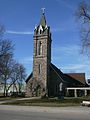 Precious Blood Cathedral, Roman Catholic Diocese of Sault Sainte Marie
 -
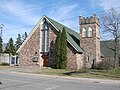 St. Luke's Cathedral, Anglican Diocese of Algoma
 -
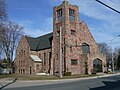
 Central United Church
 -
 St. Andrew's United Church
 -
 St. Mary's Ukrainian Catholic Church
 -
 Bishop Fauquier Memorial Chapel
 -
 St. Mary's Cross, an illuminated 37 m summit cross
 -
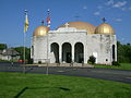
 Beth Jacob Synagogue


Government

The Corporation of the City of Sault Ste. Marie is run by a city council of 10 councillors (representing five
The city's crest contains the words "Ojibwa Kitche Gumeeng Odena" (from Ojibwe gichi-gamiing oodena) which means "Town by the large body of water of the Ojibwe" (or simply "Town by Lake Superior") in the Ojibwe language.
The city is served by the
See also Neighbourhoods in Sault Ste. Marie, Ontario.
Education


The city is home to
Sault Ste. Marie is home to the
- Korah Collegiate & Vocational School (English, public, offers the International Baccalaureate Programme)
- École Notre-Dame-du-Sault (French, Catholic)
- St. Mary's College (English with French Immersion Program, Catholic, offers Advanced Placementprograms)
- Superior Heights Collegiate & Vocational School (English and French Immersion, public, offers Advanced Placement programs)
- White Pines Collegiate & Vocational School (English, public)
Sault Ste. Marie is also home to the Ontario Forest Research Institute and the federal Great Lakes Forestry Centre.
Sault Ste. Marie has over 30 elementary schools.
Sports


The Sault Ste. Marie Greyhounds are the city's most recognized sports team having existed since the formation of the Northern Ontario Hockey Association in 1919. The Hounds won national championships twice including the 1993 Memorial Cup and the 1924 Allan Cup. The Greyhounds play in the GFL Memorial Gardens, a state-of-the-art downtown arena that replaced the Sault Memorial Gardens in 2006. The current Hounds have retired five jerseys since joining the Ontario Hockey League in 1972: #19 Joe Thornton, #1 John Vanbiesbrouck, #4 Craig Hartsburg, #10 Ron Francis, #5 Adam Foote, and #99 Wayne Gretzky.
Sault Ste. Marie also had a team in hockey's first professional league. The Sault Ste. Marie Marlboros or 'Canadian Soo' team played in the International Professional Hockey League from 1904 to 1907.
Sault Ste. Marie hockey teams have boasted a number of Hockey Hall of Fame members, including Sault natives or residents Phil Esposito, Tony Esposito, Ron Francis, and Didier Pitre, as well as Sault team members Gerry Cheevers, Paul Coffey, Bill Cook, Bun Cook, Wayne Gretzky, Newsy Lalonde, George McNamara, and Marty Walsh.
Sault Ste. Marie native
Sault Ste. Marie was the host of the 1990
Sault Ste. Marie also has a rich history in Canadian football. For nearly four decades, Sault Ste. Marie high schools have consistently won Northern Ontario honours (NOSSA) and are regular participants in provincial finals. Sault Ste. Marie has also had men's semi-pro football since 1972. The Sault Steelers are 4x National Semi-Pro champions in the Canadian Major Football League, winning the honours in 1972, 2007, 2009, and 2010. The Steelers failed to field a team in the early 1990s before returning for 4 seasons as the Sault Storm, later going back to their original name in the 2000s on their way to forming a Dynasty between 2007 and 2010. Notable names associated with the team are Len Monico (builder and coach), Don McBain (owner/president), Barry Rushon (championship coach), and Brandon Lewis (League MVP and 20x All-Star).
Other notable athletes from Sault Ste. Marie include
The Sault has been host to many national and international sporting events, including the 2003 Eco-Challenge North American Championship, an expedition-length (350–500 km or 220–310 mi)
Walk of Fame
The Walk of Fame was created in 2006 as a joint project between the city of Sault Ste. Marie and its Downtown Association, and honours those from the city or the Algoma District who have made outstanding contributions to the community or significant contributions in their chosen field of work. Inductees are added on an annual basis.
Culture
Sault Ste. Marie is home to the
Sault Ste. Marie was the focus of Kalle Mattson's "A Love Song to the City", whose music video premiered on USA Today.[68]
Egidio Coccimiglio, a film director who grew up in the city, has shot two films in the Sault Ste. Marie area, Compulsion (2013) and Cascade (2023).[69]
Notable people
- Soo Greyhounds
- Brigitte Acton, two-time Olympian alpine skier
- Michael Amadio, NHL player for the Vegas Golden Knights
- David Amber, NHL on Sportsnet reporter and anchor[70]
- Ivan Boldirev, retired NHL centre and 1978 NHL All-Star
- Roberta Bondar, neurologist and the first Canadian female astronaut in space
- Antonio Carvalho, mixed martial artist and UFC veteran
- Treble Charger, Juno Award-nominated alternative rock band
- Kerry Diotte, journalist and member of parliament
- Kyle Dubas, former general manager of the Toronto Maple Leafs
- Steve Wochy, former NHL player and the second player in its history to become a Centenarian
- Phil Esposito, Hockey Hall of Fame inductee, 10th all-time NHL goal scorer, and winner of two Stanley Cups
- Tony Esposito, Hockey Hall of Fame inductee and winner of one Stanley Cup[71]
- Aaron Fiacconi, retired CFL offensive lineman
- Patrick Dovigi, CEO of GFL Environmental
- Ron Francis, 5th All-Time leading scorer in the NHL and winner of two Stanley Cups
- William Howard Hearst, seventh premier of Ontario
- Kevin Hodson, retired NHL goalie and winner of one Stanley Cup & one Memorial Cup
- Brad Jacobs, E. J. Harnden, Ryan Harnden, Canadian curlers, 2014 Winter Olympic gold medalists and 2013 Tim Hortons Brier champions.
- Bill Johnson, Sault Ste. Marie resident unjustly convicted of murder; acquitted in 2007[72]
- The Right Honourable David Johnston CC CMM COM CD FRSC(hon) FRCPSC(hon), 28th Governor General of Canada
- Honorary Captain of the Royal Canadian Navy
- Academy Awardwinning actress
- NHLplayer
- Keith Knight, film actor
- Jerry Korab, retired defenceman for the National Hockey League from 1971 to 1985
- NHLplayer
- NHLplayer
- Mac Marcoux, visually-impaired alpine skier and gold medal winner at the 2014 Winter Paralympics[73]
- Kalle Mattson, folk rock musician
- Paul Maurice, current head coach of the NHL's Florida Panthers
- Bob McKenzie, TSN hockey broadcaster & analyst[74]
- Colin Miller, NHL player currently playing for the Dallas Stars
- Will Morin, politician and former leader of First Peoples National Party
- Jordan Nolan, NHL player currently playing for the St. Louis Blues
- Ted Nolan, former NHL player and head coach
- John Parco, retired hockey player and member of the Italian men's hockey team at the 2006 Winter Olympics
- Didier Pitre, Hockey Hall of Fame inductee and winner of one Stanley Cup
- Denis St-Jules, writer and radio broadcaster
- Crystal Shawanda, Juno Award winning country singer
- Ray Smillie, bronze medal-winning boxer at the 1928 Summer Olympics
- Lyndon Slewidge, anthem singer for the Ottawa Senators & retired policeman
- Chris Thorburn, retired NHL player
- Jessica Tuomela, visually impaired swimmer and silver medallist at the 2000 Summer Paralympics
- Marty Turco, retired NHL goalie and member of the 2006 Winter Olympics men's hockey team
- Tanya Kim, tv personality host
- Gene Ubriaco, retired NHL player, former AHL coach and coach of the Pittsburgh Penguins and current Senior Advisor/Director of Hockey Operations for the Chicago Wolves of the American Hockey League
- Brian Vallée, author, journalist, filmmaker
- Dennis Vial, retired NHL player who mainly played for the Ottawa Senators
- Jonathan Wilkinson, federal cabinet minister and businessman
Media
Sister cities
- County Louth, Ireland[75]
- Forssa, Finland[75]
- Maia, Portugal[76]
- twin city)
References
- ^ "Factacular : City Nicknames". factacular.com. Archived from the original on 2015-01-03.
- ^ "Sault Ste. Marie". Geographical Names Data Base. Natural Resources Canada.
- ^ 2011 Census of Population. Statistics Canada. Archivedfrom the original on 2016-02-02. Retrieved 2012-02-16.
- ^ 2011 Census of Population. Statistics Canada. Archivedfrom the original on 2016-02-02. Retrieved 2012-02-16.
- ^ a b c d e "Sault Ste. Marie A". Canadian Climate Normals 1981–2010. Environment and Climate Change Canada. 25 May 2022. Retrieved 29 August 2022.
- ^ "Sault Ste. Marie, Soo, Saultite". Translation Bureau. Public Works and Government Services Canada. 8 October 2009. Retrieved 16 April 2022.
- ^ "Time to say goodbye to seven-digit calls" Archived 2011-01-20 at the Wayback Machine, Sootoday
- ^ "History" Archived 2013-08-01 at the Wayback Machine, Sault Ste. Marie, Michigan website
- ^ "Saultite receives honour from the Queen". The Sault Star ~date=15 June 2015. Retrieved 2 May 2018.
- ^ "Sault Ste. Marie – history", The North View, accessed 20 Dec 2008 Archived May 12, 2008, at the Wayback Machine
- ^ "Sault Ste. Marie – history", The North View, accessed 20 Dec 2008 Archived May 12, 2008, at the Wayback Machine
- ISBN 0920474500– plaque on eastern end of Canadian locks, Huron Street, Saint Ste. Marie
- ISBN 0920474500– plaque near Canadian locks, Huron Street, Saint Ste. Marie
- ^ Low, Charles Rathbone (1878). A Memoir of Lieutenant-General Sir Garnet J. Wolseley. R. Bentley. p. 11.
- ^ Cooper, Charles (2017). "Peterborough County – A Capsule Railway History" (PDF).[permanent dead link]
- ^ Cooper, Charles (2014). "Northern Railway of Canada Group". Charles Cooper's Railway Pages.
- ^ Regehr, Theodore D. (1998). "Van Horne, Sir William Cornelius". In Cook, Ramsay; Hamelin, Jean (eds.). Dictionary of Canadian Biography. Vol. XIV (1911–1920) (online ed.). University of Toronto Press.
- ^ "Canadian Pacific Railway Company Eastern Division". Old Time Trains. 2004. Retrieved 27 July 2020.
- ^ "History of the Webbwood, Little Current Subs and the Nickel Spur". concretesoo.com. Retrieved 7 Oct 2022.
- ^ McDowall, Duncan (2016). "Clergue, Francis Hector". In Cook, Ramsay; Bélanger, Réal (eds.). Dictionary of Canadian Biography. Vol. XVI (1931–1940) (online ed.). University of Toronto Press.
- ^ Iacovetta, Franca (2005). "Napolitano (Neapolitano), Angelina". In Cook, Ramsay; Bélanger, Réal (eds.). Dictionary of Canadian Biography. Vol. XV (1921–1930) (online ed.). University of Toronto Press.
- ^ Dziuban, Stanley W. (1970). Military Relations Between the United States and Canada 1939–1945. United States Army Center of Military History. p. 196. Archived from the original on 2010-04-10. Retrieved 2010-06-30.
- ^ Canadian Annual Review of Politics and Public Affairs, 1990, David Leyton-Brown (ed.), p.135. "On the language front, a major headache for the government began when the Sault Ste Marie City Council, under pressure from the Alliance for the Preservation of English in Canada, declared English as its official language."
- ^ Heller, Crosswords, p. 80
- ^ Crosswords: Language, Education and Ethnicity in French Ontario, Monica Heller, p. 79
- ^ "July 1921". Canadian Climate Data. Environment and Climate Change Canada. 31 October 2011. Archived from the original on 7 August 2016. Retrieved 25 March 2016.
- ^ "January 1927". Canadian Climate Data. Environment and Climate Change Canada. 31 October 2011. Archived from the original on 7 August 2016. Retrieved 25 March 2016.
- Environment Canada. Retrieved Jun 14, 2024.
- ^ "Sault Ste Marie 2". Canadian Climate Normals 1981–2010. Environment and Climate Change Canada. 25 September 2013. Archived from the original on 7 August 2016. Retrieved 12 June 2016.
- ^ "Sault Ste M Forestry (1889-1933)". Canadian Climate Data. Environment and Climate Change Canada. 31 October 2011. Archived from the original on 7 August 2016. Retrieved 25 March 2016.
- ^ "Sault Ste Marie (1949-1969)". Canadian Climate Data. Environment and Climate Change Canada. 31 October 2011. Archived from the original on 7 August 2016. Retrieved 25 March 2016.
- ^ "Sault Ste Marie Insectary". Canadian Climate Data. Environment and Climate Change Canada. 31 October 2011. Archived from the original on 7 August 2016. Retrieved 25 March 2016.
- ^ "Genesee & Wyoming Reports Results for the Second Quarter of 2010 Aug 3, 2010". Genesee & Wyoming. 2010-08-03. Archived from the original on 2011-07-17. Retrieved 2010-08-04.
GWI has continued to operate HCRY under a temporary operating agreement that terminates in mid-August 2010, unless renewed by the affected parties.
- Sudbury Star, February 18, 2010.
- ^ "Boxing Day Vote – The People Have Spoken"[permanent dead link]. soonews.ca, October 26, 2010.
- ^ Sault Ste. Marie Economic Development Corporation. "Renewable Energy". Archived from the original on 13 April 2014. Retrieved 28 May 2013.
- ^ Sprott Power. "Goulais". Archived from the original on 15 November 2013. Retrieved 28 May 2013.
- ^ BluEarth Renewables Inc. "Bow Lake Wind Project". Archived from the original on 2 April 2013. Retrieved 28 May 2013.
- ^ Elementa Group. "Commercial Demonstration Plant". Archived from the original on 13 April 2014. Retrieved 28 May 2013.
- ^ Elaine, Della-Mattia (February 22, 2021). "City to budget for 'green' vehicles for 2022 and beyond". saultstar. Retrieved 2022-04-24.
- ^ "Sault Smart Grid - Sault Ste. Marie PUC". ssmpuc.com. Retrieved 2024-02-01.
- ^ Sault Ste. Marie, City of (May 4, 2021). "First-in-Canada Community Wide Smart Grid Project Advances in Sault Ste. Marie". City of Sault Ste. Marie Newsroom. Retrieved April 24, 2022.
- ^ "Justin Trudeau hangs with local kids, cuts ribbon on Canada's first community-wide smart grid at PUC". SooToday.com. 2023-11-10. Retrieved 2024-02-01.
- ^ Sault Ste. Marie Police Service
- ^ "Licence plate scans won't be 'free-for-all' -- Chief". saultstar. Retrieved 2022-04-23.
- ^ Gray, Dan. "Police chief comments on "3400 pieces of poison" | SaultOnline.com". Retrieved 2022-04-23.
- ^ "Sault Ste. Marie Transit". Saulttransitservices.com. Archived from the original on 2012-02-19. Retrieved 2011-03-09.
- ^ "Passenger rail service to Sudbury needed: Sault MP". Archived from the original on 2007-05-29. Retrieved 2011-03-09.
- ^ "Ontario Northland Operating in 20 New Communities".
- ^ "Rideshare company needs drivers". saultthisweek. Retrieved 2022-01-09.
- ^ "Spotlight: There's a new, entirely local rideshare company in town". SooToday.com. Retrieved 2022-10-20.
- ^ "John Rowswell Hub Trail". City of Sault Ste Marie. Archived from the original on February 2, 2017. Retrieved January 24, 2017.
- ^ "History of the VTA". Voyageur Trail Association. 2016. Archived from the original on February 2, 2017. Retrieved January 24, 2017.
- ^ "Algoma Trail Network Mountain Bike Master Plan – Sault Cycling Club". Retrieved 2021-08-11.
- ^ Heroux, Greg. "Sault Ste. Marie Tours - Sail Superior". sailsuperior.com/. Archived from the original on 2021-08-03. Retrieved 2021-08-11.
- ^ "New Agawa Canyon Tour Train station set to open". Northern Ontario. 2021-08-12. Retrieved 2021-08-29.
- ^ "Contract awarded for new $16-million office building one block from downtown plaza". SooToday.com. 8 October 2021. Retrieved 2022-04-16.
- ^ "Sault's downtown association back on track". Northern Ontario Business. 16 March 2018. Retrieved 2022-04-23.
- ^ Patterson, Jairus (2018-06-04). "A tourist's eye view of Sault Ste. Marie". Northern Ontario. Retrieved 2022-04-23.
- ^ "From concept to reality, plaza and market designed to draw crowds". saultstar. Retrieved 2022-04-23.
- ^ "Sault Ste. Marie, City (CY): Ontario [Census subdivision]". Statistics Canada. Retrieved 11 December 2022.
- ^ "Population and dwelling counts: Canada, provinces and territories, census divisions and census subdivisions (municipalities), Ontario". Statistics Canada. February 9, 2022. Retrieved March 27, 2022.
- ^ "Sault Ste. Marie Ontario [Census agglomeration]". Statistics Canada. Retrieved December 10, 2022.
- ^ "Ethno-Cultural Portrait of Canada, Table 1". 2.statcan.ca. Archived from the original on 2007-12-14. Retrieved 2011-03-09.
- ^ "Sault Ste. Marie, City (CY) Ontario [Census subdivision]". Statistics Canada.
- ^ "Florida Panthers Name Paul Maurice Head Coach". NHL.com. Retrieved 2023-02-12.
- ^ Miramar Design Studio. "Rotaryfest". Rotaryfest. Archived from the original on 2011-05-10. Retrieved 2011-03-09.
- ^ "Premiere: Kalle Mattson's 'A Love Song to the City'". USA Today. Archived from the original on 2017-02-04.
- Sault Star, July 5, 2023.
- ^ "David Amber NHL Network Bio". NHL Network. Archived from the original on 2010-11-24.
- ISBN 978-0-8108-7863-1. Retrieved January 14, 2024.
- ^ Harland-Logan, Sarah. "William Mullins-Johnson". Innocence Canada. Retrieved 2020-12-16.
- ^ "Sweet 16! Canada's Mac Marcoux wins bronze in Paralympic downhill in Sochi - 2014 Winter Games". 2014 Winter Games. 8 March 2014. Archived from the original on 2 September 2014.
- ^ "Hockey Chat with Bob McKenzie". TSN. April 14, 2009. Archived from the original on 2014-08-26.
- ^ a b City of Sault Ste Marie
- ^ City of Sault Ste. Marie (Ontario) Archived 2007-11-13 at the Wayback Machine
- Sault Star.
External links
Places adjacent to Sault Ste. Marie, Ontario | ||||||||||||||||
|---|---|---|---|---|---|---|---|---|---|---|---|---|---|---|---|---|
| ||||||||||||||||
| Cities |  | |
|---|---|---|
| Towns | ||
| Townships | ||
| Villages | ||
| First Nations | ||
| Indian reserves | ||
| Unorganized areas | ||
Local services boards | ||
| Unincorporated communities |
| |
| ||
| International | |
|---|---|
| National | |
| Geographic | |
| Other | |