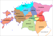
Jogentagana
| Jogentagana | |||||||
|---|---|---|---|---|---|---|---|
| county of Ancient Estonia | |||||||
| 9th Century–1224 | |||||||
 Ancient Estonian counties | |||||||
| Area | |||||||
| • Coordinates | 58°30′N 26°30′E / 58.5°N 26.5°E | ||||||
| • Type | Council of Elders | ||||||
| History | |||||||
• Established | 9th Century | ||||||
• Livonian Crusade | 1224 | ||||||
| |||||||
Jogentagana (
Estonian Crusade and became part of the Livonian Order
.
