
Königsburg
| Königsburg | |
|---|---|
Königshütte | |
| Coordinates | 51°44.505′N 10°46.031′E / 51.741750°N 10.767183°E |
| Completed | first mentioned 1312 |
| Height | 460 m above sea level (NN) |
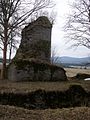
The Königsburg is a ruined medieval castle southeast of
Site
The ruins are located above the confluence of the
History
In 1312 the site is first mentioned in the records as castrum Königshof when Bishop Albrecht von Halberstadt purchased the castle from Knappen Heinrich von Botvelde. In 1324 there is another mention of it as castrum Köningshof acqisivit, then all went quiet until it is described in 1709 for the first time as Königsburg. At that time it had already fallen into ruins.
When Paul Höfer carried out extensive excavations in the years from 1898 to 1901, he assumed he had discovered the long sought after palace (Pfalz) of Bodfeld and produced several publications about it.
In 1931, Carl Schuchhardt suggested, through advances in soil research, that this was incorrect[1] and, a little later, this was confirmed by Paul Grimm, who was able to establish that the finds, especially the pottery, were not older than the 13th century. Although the results of this research from the 1930s have been consistently acknowledged within the scientific community, Königshütte still advertises today that the Königsburg is the Bodfeld hunting palace and one of the most significant historical sites in the Harz.
Site and hiking
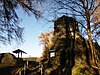
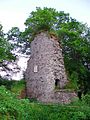
Only remnants of the
Gallery
-

-
 Information board by the castle ruins with checkpoint 41 of the Harzer Wandernadel: Ruine Königsburg
 -
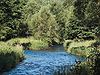 Confluence of the Warme Bode (left) and Kalte Bode (right) near Königshütte
 -

-
-
-


References
- Akademische Verlagsgesellschaft Athenaion, Potsdam, 1931, p. 227.
- ^ Harzer Wandernadel: Stempelstelle 41 / Ruine Königsburg, at harzer-wandernadel.de
External links
- Artist's impression by Wolfgang Braun