
Wurmberg
You can help expand this article with text translated from the corresponding article in German. (February 2009) Click [show] for important translation instructions.
|
Wurmberg | |
|---|---|
 Town hall | |
 Coat of arms | |
Location of Wurmberg within Enzkreis district 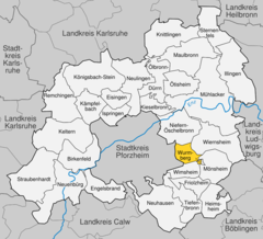 | |
 Wurmberg  Wurmberg | |
| Coordinates: 48°52′16″N 8°49′6″E / 48.87111°N 8.81833°E | |
| Country | Germany |
| State | Baden-Württemberg |
| Admin. region | Karlsruhe |
| District | Enzkreis |
| Government | |
| • Mayor (2018–26) | Jörg-Michael Teply[1] |
| Area | |
| • Total | 7.36 km2 (2.84 sq mi) |
| Elevation | 450 m (1,480 ft) |
| Population (2022-12-31)[2] | |
| • Total | 3,288 |
| • Density | 450/km2 (1,200/sq mi) |
| Time zone | UTC+01:00 (CET) |
| • Summer (DST) | UTC+02:00 (CEST) |
| Postal codes | 75449 |
| Dialling codes | 07044 |
| Vehicle registration | PF |
| Website | www |
Wurmberg is a municipality in the district of
Geography
Wurmberg is located on the so-called Platte, a Karst mountain range in the northern Black Forest (Schwarzwald).
Municipality
The municipality Wurmberg includes the districts Wurmberg and Neubärental. Wurmberg was a settlement of the
History
Wurmberg was first mentioned in documents in 1221 as a chapel was built at that time. In the following period, the Maulbronn Monastery secured the rule of Wurmberg. The monastery of Wurmberg came into Württemberg in 1504 following the Bavarian-Palatine War of Succession. At the end of the 17th Century Waldensian Protestants forced to flee from Italy settled in Wurmberg. The establishment of the district of Neubärental in 1721 goes back to these religious refugees. An originating theologian of
Religion
In 1534,
Population growth
The population figures for the respective area of jurisdiction are estimates, census results (¹) or official updates of the State Statistical Office Baden-Württemberg (only primary residences ).
| Year | Population figures |
|---|---|
| 1654 | c. 79 |
| December 1, 1871¹ | 1,126 |
| December 1, 1880 ¹ | 1,181 |
| December 1, 1890 ¹ | 1,258 |
| December 1, 1900 ¹ | 1,229 |
| December 1, 1910 ¹ | 1,213 |
| June 16, 1925 ¹ | 1,176 |
| June 16, 1933 ¹ | 1,193 |
| May 17, 1939 ¹ | 1,146 |
| 1946 | |
| September 13, 1950 ¹ | 1,393 |
| June 6, 1961 ¹ | 1,571 |
| May 27, 1970 ¹ | 2,025 |
| June 30, 1980 | 2,191 |
| May 27, 1987 ¹ | 2,241 |
| December 31, 1990 | 2,519 |
| December 31, 1995 | 2,620 |
| December 31, 2000 | 2,826 |
| December 31, 2005 | 2,904 |
| December 31, 2010 | 3,014 |
Economy and infrastructure
The nearest railway station is Pforzheim main station, located about 10 km west of Wurmberg. Even closer to the breakpoint is Niefern on the route Pforzheim Mühlacker. Bus lines 739, 761, 763 and 769 of the Verkehrsverbund Pforzheim-Enzkreis connect Wurmberg with Pforzheim.
Education
Wurmberg has its own primary school.
External links
References
- ^ Bürgermeisterwahl Wurmberg 2018, Staatsanzeiger, accessed 29 August 2022.
- Statistisches Landesamt Baden-Württemberg. June 2023.
- ^ The Beck'sche Reformbewegung from 1712 to 1719, baerenthal.de, 27. Februar 2018.

| Authority control databases: National |
|---|