
Kaag en Braassem
Kaag en Braassem | |
|---|---|
Municipality | |
 Island of Kaag | |
|
UTC+2 (CEST) | |
| Postcode | 2355, 2370–2377, 2450–2451, 2465, 2480–2481 |
| Area code | 0172, 071 |
| Website | www |
Kaag en Braassem (Dutch pronunciation: [ˌkaːx ʔɛn ˈbraːsəm]) is a municipality in the western Netherlands, in the province of South Holland. It was formed on 1 January 2009, through the merger of Alkemade and Jacobswoude.
Kaag en Braassem consists of 10 towns:
In addition, there are 5 hamlets:
- Bilderdam
- Heimansbuurt
- Ofwegen
- Vriezekoop
- Zevenhuizen
Topography

Dutch topographic map of the municipality of Kaag en Braassem, June 2015
Notable people

- Marinus Heijnes (1888 – 1963 in De Kaag) a Dutch impressionist artist of the Hague School
Sport
- Cornelis van Staveren (1889 in Leimuiden – 1982) a sailor who competed at the 1928 Summer Olympics
- Joop Zoetemelk (born 1946) a retired professional racing cyclist, raised in Rijpwetering
- Monique Velzeboer (born in Oud Ade 1969) a Dutch skater and photographer, medallist in the 1998 Winter Olympics
- Michael Buskermolen (born 1972 in Leimuiden) a Dutch retired footballer with 399 club caps with AZ Alkmaar
- Bob de Jong (born 1976 in Leimuiden) a Dutch former speed skater, silver, gold and twice bronze medallist at the 1998 2006 2010 and 2014 Winter Olympics
- Margot Boer (born 1985 in Woubrugge) a Dutch former speed skater, competed in the 2010 and 2014 Winter Olympics
- Claudia van den Heiligenberg (born 1985 in Roelofarendsveen) a Dutch footballer
- Femke Heemskerk (born 1987 in Roelofarendsveen) a Dutch competitive swimmer, gold and silver medallist at the 2008 and 2012 Summer Olympics
Gallery
-
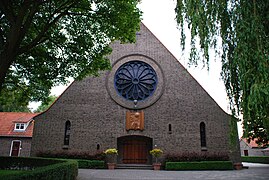 Maria Presentatiekerk - Roelofarendsveen
 -
 Roelofarendsveen, small bridge in the street
 -
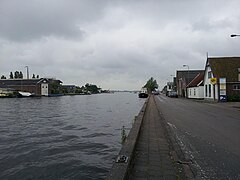
 Woubrugge
 -
 Rijnsaterwoude - Priester Hendrik
 -
 Oude Wetering de Wetering
 -
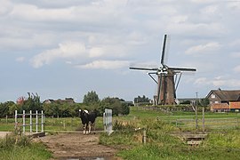 Rijpwetering, windmill: Lijkermolen no1


References
- ^ "Gemeentelijke indeling op 1 januari 2009" [Municipal divisions on 1 January 2009]. cbs.nl (in Dutch). CBS. Retrieved 31 July 2013.
- ^ "Collegeleden" [Members of the board] (in Dutch). Gemeente Kaag en Braassem. Archived from the original on 7 September 2013. Retrieved 31 July 2013.
- ^ "Kerncijfers wijken en buurten 2020" [Key figures for neighbourhoods 2020]. StatLine (in Dutch). CBS. 24 July 2020. Retrieved 19 September 2020.
- ^ "Postcodetool for 2371AS". Actueel Hoogtebestand Nederland (in Dutch). Het Waterschapshuis. Archived from the original on 21 September 2013. Retrieved 31 July 2013.
- ^ "Bevolkingsontwikkeling; regio per maand" [Population growth; regions per month]. CBS Statline (in Dutch). CBS. 1 January 2021. Retrieved 2 January 2022.
External links
Places adjacent to Kaag en Braassem | ||||||||||||||||
|---|---|---|---|---|---|---|---|---|---|---|---|---|---|---|---|---|
| ||||||||||||||||

| International | |
|---|---|
| Geographic | |