
Maassluis
This article needs additional citations for verification. (January 2011) |
Maassluis | |
|---|---|
Municipality | |
 Aerial view of Maassluis | |
|
UTC+2 (CEST) | |
| Postcode | 3140–3147 |
| Area code | 010 |
| Website | www |
Maassluis (Dutch pronunciation: [maːˈslœys] ⓘ) is a city in the western Netherlands, in the province of South Holland. The municipality had a population of 33,567 in 2021 and covered 10.12 km2 (3.91 sq mi) of which 1.64 km2 (0.63 sq mi) was water.
It received
History

Maassluis was founded circa 1340 as a settlement next to a
On 16 May 1614, Maeslandsluys was separated from Maesland by the counts of Holland and renamed Maassluis. This separation may have been religiously motivated: Maassluis was predominantly Protestant and Maasland Catholic. In 1624 the defense wall was demolished to make way for the Great Church, started in 1629. Construction stopped for five years because privateers from Dunkirk raided fishing boats from Maassluis, throwing their crew overboard. It was finished in 1639. On 4 December 1732, the Garrels Organ was inaugurated. Built from 1730 to 1732 by Rudolf Garrels, a pupil of Arp Schnitger, it was a gift by Govert van Wijn, ship-owner from Maassluis.[6]
In 1811
During World War II, the working population was transferred to Germany for the war industry. Maassluis' ancient church was hit by allied bombers.


Jewish history
The Jewish community had its own synagogue, a teacher, a singer and a ritual butcher. Its most common professions were salesman, street trader and butcher. The economy was vulnerable and community growth ended with the industrial revolution. The area became easier to reach and competition became too much. The number of Jews fell from 92 to eight between 1892 and 1930. A cause was the building of a railway in 1881 between Maassluis and Rotterdam. Most Jewish traders moved to Rotterdam, The Hague and Amsterdam, which in the last decade of the 19th century had a growing Jewish population.
Integration in Maassluis ended during the Second World War. The Coltof and Van Gelderen families were deported in 1942 and murdered in Auschwitz.
Economy
Maassluis was historically dependent on the fishing near the coast and off Iceland. In the 19th century the tugboat company, L. Smit, and the marine salvage company W.A. van den Tak merged to become Smit-Tak, now a division of the world's largest salvage company, Smit International. Also, there is still a large shipping agency called Royal Dirkzwager. Maassluis is now mainly a commuter town for Rotterdam.
People born in Maassluis
.jpg)

- Bartholomeus Meyburgh (1624-1708) a Dutch Golden Age painter of portraits and history
- Abraham Kuyper (1837-1920) journalist, theologian & Prime Minister of the Netherlands 1901/1905
- Louis Fles (1872-1940), businessman, activist and author
- Cornelis Lievense (1890-1949) businessman, president of the Union Banking Corporation
- Arie Bijl (1908–1945) a Dutch theoretical physicist and WWII resistance man
- brothers Bas van Toor (born 1935) & Aad van Toor (born 1942), clowns, a former Dutch circus duo
- Maarten 't Hart (born 1944) biologist and writer
- Agnes van Ardenne (born 1950) a retired Dutch politician and diplomat
- Niko Koffeman (born 1958) a Dutch politician and animal rights activist
- Chris Woerts (born 1959) former journalist, businessman interested in sport
Sport
- Jan Verhaas (born 1966), a Dutch snooker and pool referee
- Koen Pijpers (born 1969), a Dutch retired field hockey player
- Françoise Harteveld (born 1977), a Dutch judoka
- Khalid Boulahrouz (born 1981), a Dutch former footballer with 235 club caps
- Tonny Trindade de Vilhena(born 1995), footballer with over 200 club caps
In media
Maassluis was the setting for Spetters, filmed by director Paul Verhoeven in 1980.
Image gallery
-
 Great Church of Maassluis
 -
 Tugboat (de Furie) with church (de Groote Kerk)
 -
 Ship: De Furie during national arrival of Sinterklaas in Maassluis
 -
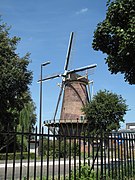 Windmill: de Hoop
 -
 Windmill: de Wippersmolen
 -
 Historic building from 1649
 -
 Streetview: de Doctor Kuyperkade
 -
 The "Marnixkade"
 -
 Streetview: the Wip
 -
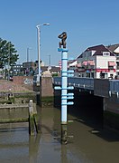 Flow pole with statue
 -
 Sculpture (de Calypso)
 -
 Artwork floating on raft
 -
 War memorial by Ek van Zanten


References
- ^ "Burgemeester dr. T.J. (Edo) Haan" [Mayor dr. T.J. (Edo) Haan] (in Dutch). Gemeente Maassluis. Archived from the original on 12 October 2013. Retrieved 13 August 2013.
- ^ "Kerncijfers wijken en buurten 2020" [Key figures for neighbourhoods 2020]. StatLine (in Dutch). CBS. 24 July 2020. Retrieved 19 September 2020.
- ^ "Postcodetool for 3144BA". Actueel Hoogtebestand Nederland (in Dutch). Het Waterschapshuis. Archived from the original on 21 September 2013. Retrieved 13 August 2013.
- ^ "Bevolkingsontwikkeling; regio per maand" [Population growth; regions per month]. CBS Statline (in Dutch). CBS. 1 January 2021. Retrieved 2 January 2022.
- ^ Chisholm, Hugh, ed. (1911). . Encyclopædia Britannica. Vol. 17 (11th ed.). Cambridge University Press. p. 188.
- ^ "The Organ of the Great church of Maassluis".
External links
Places adjacent to Maassluis | |
|---|---|

| International | |
|---|---|
| National | |
| Geographic | |