
Kahiltna Queen
| Kahiltna Queen | |
|---|---|
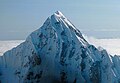
 Aerial view from WSW | |
| Highest point | |
| Elevation | 12,380 ft (3,773 m)[1][2] |
| Prominence | 1,430 ft (440 m)[1] |
| Parent peak | Peak 13050 [1] |
| Isolation | 1.46 mi (2.35 km)[1] |
| Coordinates | 62°58′49″N 151°02′27″W / 62.980372°N 151.040952°W[3] |
| Geography | |
 Kahiltna Queen Location of Kahiltna Queen in Alaska | |
| Country | United States |
| State | Alaska |
| Borough | Matanuska-Susitna |
| Protected area | Denali National Park |
| Parent range | Alaska Range[3] |
| Topo map | USGS Talkeetna D-3 |
| Geology | |
| Mountain type | Glacial horn |
| Type of rock | Granite[4] |
| Climbing | |
| First ascent | 1977 |
Kahiltna Queen is a 12,380-foot-elevation (3,773-meter) mountain summit in the U.S. state of Alaska.
Description
Kahiltna Queen is located 140 miles (225 km) north of
Etymology
The mountain's toponym commemorates Frances Randall (1925-1984), the first Denali Base Camp manager for nine climbing seasons (1974-1983).
Climate
Based on the Köppen climate classification, Kahiltna Queen is located in a Tundra climate zone with long, cold, snowy winters, and cool summers.[11] Weather systems are forced upwards by the Alaska Range (orographic lift), causing heavy precipitation in the form of snowfall. Winter temperatures can drop below −20 °F with wind chill factors below −30 °F. The months May through June offer the most favorable weather for viewing and climbing.[12]
See also
- Mount Frances
- Mountain peaks of Alaska
- Geography of Alaska
 Mountains portal
Gallery
-
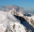
 West aspect
 -
 West aspect
 -
 Kahiltna Queen at upper right, viewed from north slope of Mount Hunter.
Head of Southeast Fork Kahiltna Glacier below. -
 Kahiltna Queen in lower right with Mt. Hunter (left), Mt. Foraker (top), and Mt. Crosson (upper right) in 1940s


References
- ^ a b c d "Kahiltna Queen - 12,380' AK". listsofjohn.com. Retrieved 2023-11-12.
- ^ a b Highest Alaskan summits, National Park Service, nps.gov, Retrieved 2023-11-12.
- ^ a b c "Kahiltna Queen, Alaska". Peakbagger.com. Retrieved 2023-11-12.
- ^ Guided Alpine Climbing in the Alaska Range, American Alpine Institute, Retrieved 2023-11-12.
- ^ North America, United States, Alaska, Denali National Park, Peak 12,380' (Kahiltna Queen), South Face Couloir and Distant Lights, 2004, American Alpine Journal, americanalpineclub.org
- ^ West Face, Kahiltna Queen, Supertopo, supertopo.com, Retrieved 2023-11-12.
- ^ NPS 1984 Annual Report
- ^ Frances D Randall americanalpineclub.org
- ^ To the Top of Denali: Climbing Adventures on North America's Highest Peak, Bill Sherwonit author, Third Edition (2012), Alaska Northwest Books.
- ISBN 9780786493395, p. 15.
- ISSN 1027-5606.
- ^ Denali FAQ, American Alpine Institute, alpineinstitute.com, Retrieved 2024-01-08.
External links
- Weather forecast: Kahiltna Queen
- Kahiltna Queen (photo): Flickr
- Kahiltna Queen (photo): Flickr
Places adjacent to Kahiltna Queen | ||||||||||||||||
|---|---|---|---|---|---|---|---|---|---|---|---|---|---|---|---|---|
| ||||||||||||||||