
Kakopetria
Kakopetria | ||
|---|---|---|
| Κακοπετριά ( Postal code 2800 | ||
| Website | http://www.kakopetria.org.cy/ | |
Kakopetria is a town in
Landscape
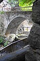
Kakopetria is surrounded by thick forestland and is built on the banks of the Kargotis and Garillis Rivers.[2] The two rivers join within village itself and form the river Klarios, which crosses the Solea Valley and empties into Morphou Bay.[2]
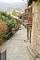
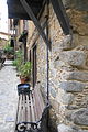
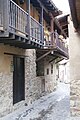
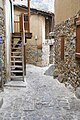
The settlement of Kakopetria is constructed along the valley of the Kargotis and Garillis rivers. The new Kakopetria with its large, modern houses and their tiled roofs, built in the gradient ground and the riverbanks, is located in the eastern part of the valley. The old Kakopetria is built west of the valley and between the two rivers. The roofs of the houses are sloped and tiled and almost all of the houses have an upper floor and a wooden balcony.
History

The settlement of Kakopetria, although mentioned by the Mediaeval annalists, existed -at least -since the Frank domination era (Lusignan Period 1192–1489).[2]
The village's region was inhabited around the 6th-7th centuries and the various excavations that have been conducted in 1938 around the old village of Kakopetria (in the Ailades venue) prove this.
Agios Nikolaos tis Stegis
Near Kakopetria there is church
Village name
There are two versions about the origin of the village's name.[2] According to first version Kakopetria name is a compound of greek words "kako" (bad) and "petra" (stone, rock).[2] According to second version the name comes from a legend about a big rock called "Petra tou Androgynou" (Couples' Rock).[2] That rock is now close to the bridge and newly wedded couples would sit on it, until according to legend the rock rolled over one couple and that rock they called bad rock.[2]
-
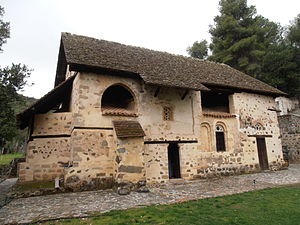 Agios Nikolaos tis Stegis
 -
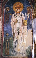 St. Nicholas
 -
 St George and Theodor
 -
 Birth of Christ


References
-
-
-

-

-
-
-

-
-
 Bad stone


| International | |
|---|---|
| National | |