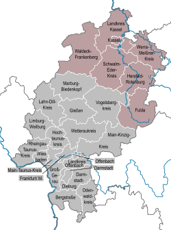
Kassel (region)
Kassel
Regierungsbezirk Kassel | |
|---|---|
 Map of Hesse highlighting Kassel | |
| Country | Germany |
| State | Hesse |
| Region seat | Kassel |
| Government | |
| • District President | Mark Weinmeister (CDU) |
| Area | |
| • Total | 8,288.7 km2 (3,200.3 sq mi) |
| Population (31 December 2022)[1] | |
| • Total | 1,235,899 |
| • Density | 150/km2 (390/sq mi) |
| GDP | |
| • Total | €50.053 billion (2022) |
| Website | www |
Kassel is one of the three American Occupation Zone, the precursor to the modern state of Hesse. In its modern form it consists of 138 municipalities.
Kreise
(districts)
(districts)
- Fulda
- Hersfeld-Rotenburg
- Kassel
- Schwalm-Eder-Kreis
- Waldeck-Frankenberg
- Werra-Meißner
Economy
The Gross domestic product (GDP) of the region was €45.4 billion in 2018, accounting for 1.4% of German economic output. GDP per capita adjusted for purchasing power was €34,200 or 113% of the EU27 average in the same year. The GDP per employee was 96% of the EU average.[3]
References
- Hessisches Statistisches Landesamt. June 2023.
- ^ "EU regions by GDP, Eurostat". Retrieved 18 September 2023.
- ^ "Regional GDP per capita ranged from 30% to 263% of the EU average in 2018". Eurostat.
