
Kearny, Arizona
Kearny, Arizona | ||
|---|---|---|
FIPS code 04-37200 | | |
| GNIS feature ID | 6633 | |
| Website | Town of Kearny | |
Kearny is a town in
History
Kearny was built by the
Geography
Kearny is located at 33°3′15″N 110°54′32″W / 33.05417°N 110.90889°W (33.054160, -110.908857).[3]
The town sits near the Gila River in the Copper Basin area along with its sister cities,
Climate
According to the
Demographics
| Census | Pop. | Note | %± |
|---|---|---|---|
| 1960 | 902 | — | |
| 1970 | 2,829 | 213.6% | |
| 1980 | 2,646 | −6.5% | |
| 1990 | 2,262 | −14.5% | |
| 2000 | 2,249 | −0.6% | |
| 2010 | 1,950 | −13.3% | |
| 2020 | 1,741 | −10.7% | |
| U.S. Decennial Census[5] | |||
| Part of a series of the |
| Cities, towns and CDPs in Arizona with lists and images of historic properties, forts, cemeteries or historic districts |
|---|
 |
As of the
There were 791 households, out of which 34.8% had children under the age of 18 living with them, 65.0% were married couples living together, 9.2% had a female householder with no husband present, and 22.1% were non-families. 19.1% of all households were made up of individuals, and 10.6% had someone living alone who was 65 years of age or older. The average household size was 2.84 and the average family size was 3.25.
In the town, the population was spread out, with 29.9% under the age of 18, 7.6% from 18 to 24, 21.7% from 25 to 44, 26.7% from 45 to 64, and 14.1% who were 65 years of age or older. The median age was 37 years. For every 100 females, there were 96.8 males. For every 100 females age 18 and over, there were 89.5 males.
The median income for a household in the town was $39,906, and the median income for a family was $42,313. Males had a median income of $40,056 versus $23,684 for females. The
Education
Kearny is part of the
Transportation
Images

-
 Porter Air Locomotive built in 1925
 -
 Different view of the Porter Air Locomotive
 -
 Rail and Copper Park
 -
 Mining Cars in the Rail and Copper Park
 -
 The Jake Jacobson Caboose in the Rail and Copper Park
 -
 Ray Mine
 -
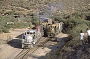 Copper Basin Railway trains at Ray Junction in Kearny, around 1987


.jpg)
See also
- List of cities and towns in Arizona
- Ray, Arizona
References
- ^ "2020 U.S. Gazetteer Files". United States Census Bureau. Retrieved October 29, 2021.
- ^ "U.S. Census website". United States Census Bureau. Retrieved August 31, 2014.
- ^ "US Gazetteer files: 2010, 2000, and 1990". United States Census Bureau. February 12, 2011. Retrieved April 23, 2011.
- ^ Climate Summary for Kearny, Arizona
- ^ "Census of Population and Housing". Census.gov. Retrieved June 4, 2016.
- ^ "U.S. Census website". United States Census Bureau. Retrieved January 31, 2008.
- ^ "Kearny Airport". Arizona Department of Transportation. Retrieved August 23, 2021.
- ^ "Past Airports of the Year". Arizona Department of Transportation. Retrieved August 23, 2021.
- PDF. Federal Aviation Administration. Effective July 29, 2010.
External links
- Official website
- Ray Unified School District
- Copper Basin Chamber of Commerce
- History of the Kearny area
- How Kearny got its history
 | ||||
Towns | ||||
| CDPs |
| |||
| Populated places | ||||
| Indian reservations | ||||
| Ghost towns | ||||
| Footnotes | ‡This populated place also has portions in an adjacent county or counties | |||
| ||||
| International | |
|---|---|
| National | |
| Other | |