
Keila Parish
Keila Parish
Keila vald | |
|---|---|
 Keila-Joa waterfall | |
 Flag  Coat of arms | |
 Keila Parish within Harju County. | |
| Country | |
| County | |
| Administrative centre | Keila |
| Government | |
| • Mayor | Jaan Alver (2014–2017) |
| Area | |
| • Total | 178.97 km2 (69.10 sq mi) |
| Population (01.01.2004) | |
| • Total | 3,995 |
| • Density | 22/km2 (58/sq mi) |
| Website | www.keilavald.ee |
Keila Parish (Estonian: Keila vald) was a rural municipality in north-western Estonia. It was a part of Harju County. The municipality had a population of 3,995 (as of 1 January 2004)[1] and covered an area of 178.97 km2. The population density was 22.3 inhabitants per km2.
Local administration of the municipality was located in the town of
Laoküla, Laulasmaa, Lehola, Lohusalu, Maeru, Meremõisa, Nahkjala, Niitvälja, Ohtu, Põllküla, Tõmmiku, Tuulna, Valkse
.
Keila Parish was one of the four municipalities merged into Lääne-Harju Parish with the administrative reform of 2017. The last mayor (vallavanem) from 2014 to 2017 was Jaan Alver from the Estonian Reform Party.
Gallery
-
 Ohtu bog
 -
 Treppoja
 -
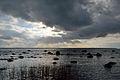 Lahepere bay and Pakri peninsula
 -
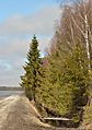
 Tallinn–Paldiski road in Valkse
 -
 Offering spring in Ohtu
 -
 Kõltsu manor


References
- ^ "Arengukava 2004-2014" (PDF) (in Estonian). Keila Vald http://www.keilavald.ee. Archived from the original (PDF) on 16 July 2011. Retrieved 11 December 2009.
{{cite web}}: External link in|publisher=
External links
59°21′05″N 24°35′56″E / 59.35139°N 24.59889°E
| Urban municipalities | ||
|---|---|---|
| Rural municipalities | ||
This Estonia location article is a stub. You can help Wikipedia by expanding it. |