
Kennon Road
This article may require copy editing for grammar, style, cohesion, tone, or spelling. (December 2023) |
.svg) | |
|---|---|
| Benguet Road Rosario–Baguio Road | |
N54 | |
| Restrictions |
|
| Major junctions | |
| North end | N54 (Governor Pack Road) in Baguio |
| |
| South end | N2 (MacArthur Highway) in Rosario, La Union
|
| Location | |
| Country | Philippines |
| Provinces | Benguet, La Union |
| Major cities | Baguio |
| Towns | Rosario, Pugo, Tuba |
| Highway system | |
| |
Kennon Road, also known as the Rosario–Baguio Road, is a two lane 33.53-kilometer (20.83 mi)
The entire road forms part of National Route 54 (N54) of the Philippine highway network.
Route description
As one of the four major access roads from the lowlands that lead to the highland city of Baguio,[3] most of Kennon Road's stretch encompasses the municipality of Tuba in the province of Benguet.[4]
Settlements along the highway, known as Camps 1 to 8, were originally established for the pioneer builders of the road,
The highway is a
History

_(14786316433).jpg)

As the American colonial government wanted to make Baguio a summer retreat to solidify Manila’s position, they decided to build a sturdy and reliable road to go there. They first tapped Charles W. Mead, who was a civil engineer, but he was subsequently replaced by Colonel N.M. Holmes. Two years after in 1903, the project was turned over to the administration of Lyman Kennon.[6]
The construction of the road commenced in 1903 by cutting across the mountains of Benguet with the combined efforts of various
More than 2,300 foreign and local workers worked on the road. Aside from Filipino engineers and construction workers and U.S. Army Corps of Engineers headed by Col. Lyman Kennon, foreigners from 36 countries were recruited to work on the road; the majority, at about 1,500 or 22%, were Japanese, and about 1,000 were Chinese.
The original road was a Macadam Telford-type road which was later improved into an all-weather asphalt roadway. More recently, some portions of Kennon Road have been replaced with concrete pavement.[10]
The highway was severely damaged by the
In December 2021, Republic Act No. 11604 was signed into law which mandates the Department of Public Works and Highways to undertake the full rehabilitation and maintenance of Kennon Road.[16]
Kennon Road rock shed
The DPWH-CAR Director Khadaffy Tanggol announced that the P264 million rock shed construction along Camp 6, Tuba, Benguet is 64.37 percent complete. The 152-meter shed, which will be the catchment area for slope debris is expected to be finished on September. However, the Road will be closed for 2 months due to the prefabricated shed installation after having completed the Bued River columns.[17]
Road hazards

Kennon Road is one of the most hazardous roads in the Philippines,
Portions of the highway are also prone to
It usually takes an experienced commuter from 45 minutes to an hour to negotiate the 41.2-kilometer (25.6 mi) steep and winding climb by car.[10]
Intersections
Intersections are numbered by kilometer posts, with Rizal Park in Manila designated as kilometer zero.
| Region | Province | City/Municipality[a] | km[a] | mi | Destinations | Notes |
|---|---|---|---|---|---|---|
| ) | Southern terminus | |||||
| Pugo | No major junctions | |||||
| Camp 1 toll gate | ||||||
| Ilocos Region–CAR boundary | La Union–Benguet boundary | Pugo–Tuba boundary | 215.155– 215.158 | 133.691– 133.693 | La Union 2nd District Engineering Office–Benguet 1st Engineering Office highway boundary | |
| Cordillera Administrative Region | Benguet | Tuba | Camp 1 Bridge 1 over Bued River | |||
| Colorado Bridge | ||||||
| 227.038 | 141.075 | Ampasit Bridge | ||||
| 227.784 | 141.538 | Camp 3 Bridge 2 | ||||
| Ataki Bridge | ||||||
| Camp 4 Bridge 1 over Bued River | ||||||
| 231.127 | 143.616 | Camp 4 Bridge 2 | ||||
| Pugo Bridge over Bued River | ||||||
| 232.259 | 144.319 | Maramal Bridge over Bued River | ||||
| Camp 4 Bridge 4 | ||||||
| 233.358 | 145.002 | Camp 4 Bridge 5 | ||||
| Camp 5 Bridge 1 | ||||||
| 235.465 | 146.311 | Camp 5 Bridge 2 | ||||
| 237.940 | 147.849 | Camp 6 Bridge | ||||
| Demonstration Bridge over Basa Creek | ||||||
| Camp 6 toll gate | ||||||
| Tuba–Baguio boundary | 239.593– 240.899 | 148.876– 149.688 | Benguet 1st District Engineering Office–Baguio City Engineering Office highway boundary. Lion's Head. | |||
N231 (Loakan Road ) | ||||||
| 246.550 | 153.199 | |||||
| Military Cut-off Road | ||||||
| 248.147 | 154.191 | N208 (Aspiras–Palispis Highway ) | Roundabout. Northern terminus. | |||
| 1.000 mi = 1.609 km; 1.000 km = 0.621 mi | ||||||
Gallery
-
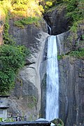 Bridal Veil Falls in the Bued River Canyon viewed from Kennon Road
 -
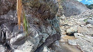 Sandstone layers of the Zigzag formation found below the Zigzag road


Notes
References
- ^ a b Kennon, Lyman. "Kennon's own report on the famous zig–zag". Baguio Midland Courier. Retrieved September 30, 2014.
- ^ a b Bankoff, Greg. (2005). These brothers of ours: Poblete's obreros and the road to Baguio 1903–1905. Journal of Social History - Volume 38, Number 4, Summer 2005, pp. 1047-1072 PDF at University of Auckland
- ^ a b c "Kennon Road". City of Pines. Archived from the original on October 26, 2014. Retrieved September 30, 2014.
- ^ "Kennon Rd" (Map). Mapcentral. Retrieved September 30, 2014.
- ^ Montecillo, Paolo (March 14, 2012). "Hike in toll on Kennon Road looms". Philippine Daily Inquirer. Retrieved September 30, 2014.
- ^ Tinio McKenna, Rebecca (2019). American Imperial Pastoral: The Architecture of US Colonialism in the Philippines. Ateneo de Manila University Press.
- ^ "Baguio City Centennial September 1, 1909". Balita Pinoy. Retrieved December 1, 2010.
- ^ Afable, Patricia (2008). "Compelling Memories and Telling Archival Documents and Photographs: The Search for the Baguio Japanese Community" (PDF). Asian Studies. 44 (1).
- ^ https://thephilippinestoday.com/kennon-road-history/
- ^ a b "CityofPines.com - Kennon Road". Archived from the original on October 26, 2014. Retrieved August 8, 2006.
- ^ a b Cabreza, Vincent (May 16, 2012). "Fighting for century-old Kennon Road". Philippine Daily Inquirer. Retrieved October 5, 2014.
- ^ Ilao, Micaella (July 29, 2017). "Kennon Road closed due to landslides". ABS-CBN. Retrieved April 2, 2021.
- ^ Alimondo, Lauren (September 25, 2020). "Constructions on Kennon Road to continue". Sunstar Baguio. Retrieved April 2, 2021.
- ^ "Improvement, Operation, and Maintenance of Kennon Road Project". Republic of the Philippines - Public-Private Partnership Center. Retrieved April 2, 2021.
- ^ Balinbin, Arjay (February 3, 2021). "European firm's consulting services for Kennon Road start". BusinessWorld. Retrieved April 2, 2021.
- ^ Parrocha, Azer. "PRRD signs law mandating full rehab, maintenance of Kennon Road". PNA. Retrieved January 15, 2022.
- ^ See, Dexter (May 30, 2024). "P264-M Kennon Road rock shed completed". The Manila Times. Retrieved June 2, 2024.
- ^ Cawis, Redjie Melvic (June 10, 2016). "DPWH advises motorists to avoid Kennon Road due to rehab works". Philippine Information Agency. Retrieved September 3, 2016.
- ^ a b "Kennon Road". Dangerous Roads. Retrieved September 30, 2014.
- ^ "Rains trigger landslide along Kennon Road in Benguet". GMA News. April 30, 2010. Retrieved September 30, 2014.
- ^ Locsin, Joel (September 15, 2014). "Kennon Road closed, 11 roads impassable due to landslides caused by Luis". GMA News. Retrieved September 30, 2014.
- ^ "1 killed in Benguet landslide; Kennon Road closed". GMA News. August 12, 2013. Retrieved September 30, 2014.
- ^ Arthur, Allad-iw (August 26, 2014). "Residents of sinking Kennon Road village urged to move to safer ground". Northern Dispatch (InterAksyon). Retrieved September 30, 2014.
- Department of Public Works and Highways. Retrieved May 22, 2016.
- Department of Public Works and Highways. Retrieved May 22, 2016.
- Department of Public Works and Highways. Retrieved May 22, 2016.
External links
 Media related to Kennon Road at Wikimedia Commons
- City of Pines.com - Kennon Road Archived October 26, 2014, at the Wayback Machine
- GoBaguio.com - Kennon Road and Baguio
| National roads |
| |||||||
|---|---|---|---|---|---|---|---|---|