
Kesra
Kesra
(كسرى) Kessera | |
|---|---|
Commune and town | |
UTC+1 (CET ) |
Kesra is a town and commune in the Siliana Governorate, Tunisia. As of 2004 it had a population of 2,490.[1] In 2014 this was 2,600. Kesra is in Siliana Governorate near Maktar at 35.8N and 9.36e.[2] The town is at altitude of 966m and is near the Jebel Serj national park. During the
Byzacena called Cusira
.
A flat bread made of Semolina is also called Kesra in north Africa.
-
 Kesra national park
 -
 Kesra nature reserve
 -
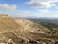 Panorama of Kesra
 -
 Panorama of Kesra
 -


See also
References
- ^ (in French) Recensement de 2004 (Institut national de la statistique)
- ^ Kesra, Splender and miserable un village
35°49′N 9°22′E / 35.817°N 9.367°E
This Tunisia location article is a stub. You can help Wikipedia by expanding it. |