
Béja
Béja
باجة | |
|---|---|
 Béja Skyline | |
|
UTC+2 (CEST) | |
| Website | www |
Béja (
History
Etymology
Classical era period
The city endured brutal assaults by the
The Romans destroyed the old Carthaginian citadel and replaced it with a new one; they built fortifications that are still standing today. Under the Roman domination, Béja became prosperous and was the center of a diocese. According to Sallust, who relates the details of the Jugurthine War between Jugurtha and Quintus Caecilius Metellus Numidicus to possess Béja, Béja was the wealthiest warehouse of the kingdom and the center of intense commerce.
The city was taken and destroyed by the Vandals. The citadel and ramparts were demolished. The abandoned town remained in that state for a century until the arrival of the Byzantines. They renovated the fortress and took real pleasure in beautifying Béja.
After the
Modern Period
In 1880 France occupied Tunisia. On April 24, 1881, Béja in its turn was occupied by the column led by Logerot who had arrived from Algeria through the Kef.
World War II
On November 16, 1942, a German military delegation came to Béja to give Mayor Jean Hugon a 24-hour ultimatum to surrender the city. In response to the ultimatum the Mayor informed civil governor, Clement, who in turn sent the message to Algiers. The next day, November 17, the first British parachute battalion landed on the hills north of the city. On Thursday November 19 German planes bombed the town for the first time, as a warning. This broke the long period of peace Béja had known for many centuries. The next day, Friday November 20, Béja was heavily bombed by German airplanes for many hours, because of its key position leading to the roads of Tabarka, Mateur, Bizerte and Algeria. The town became the stage for ferocious battles between the Germans and the Allies who fiercely defended it, at the expense of severe military and civil losses. The final German assault Operation Ochsenkopf – was launched from Mateur and was halted 15 kilometres (10 mi) from Béja, on the night of February 28, 1943, by British troops.
Geographical features
Located in
Climate
Béja has a
| Climate data for Béja (1991–2020, extremes 1953–2021) | |||||||||||||
|---|---|---|---|---|---|---|---|---|---|---|---|---|---|
| Month | Jan | Feb | Mar | Apr | May | Jun | Jul | Aug | Sep | Oct | Nov | Dec | Year |
| Record high °C (°F) | 24.7 (76.5) |
28.0 (82.4) |
34.8 (94.6) |
36.5 (97.7) |
42.5 (108.5) |
47.0 (116.6) |
47.7 (117.9) |
48.9 (120.0) |
46.4 (115.5) |
41.0 (105.8) |
30.7 (87.3) |
31.0 (87.8) |
48.9 (120.0) |
| Mean daily maximum °C (°F) | 15.4 (59.7) |
16.1 (61.0) |
19.1 (66.4) |
22.5 (72.5) |
27.8 (82.0) |
33.0 (91.4) |
36.2 (97.2) |
36.7 (98.1) |
31.6 (88.9) |
27.1 (80.8) |
20.8 (69.4) |
16.4 (61.5) |
25.2 (77.4) |
| Daily mean °C (°F) | 10.2 (50.4) |
10.4 (50.7) |
12.6 (54.7) |
15.4 (59.7) |
19.7 (67.5) |
24.3 (75.7) |
27.5 (81.5) |
28.3 (82.9) |
24.6 (76.3) |
20.4 (68.7) |
15.1 (59.2) |
11.4 (52.5) |
18.3 (64.9) |
| Mean daily minimum °C (°F) | 5.0 (41.0) |
4.8 (40.6) |
6.1 (43.0) |
8.3 (46.9) |
11.6 (52.9) |
15.7 (60.3) |
18.8 (65.8) |
19.8 (67.6) |
17.7 (63.9) |
13.8 (56.8) |
9.4 (48.9) |
6.3 (43.3) |
11.4 (52.5) |
| Record low °C (°F) | −4.5 (23.9) |
−3.5 (25.7) |
−3.0 (26.6) |
−1.0 (30.2) |
2.0 (35.6) |
5.2 (41.4) |
8.5 (47.3) |
9.5 (49.1) |
7.0 (44.6) |
1.5 (34.7) |
−0.7 (30.7) |
−3.0 (26.6) |
−4.5 (23.9) |
| Average precipitation mm (inches) | 86.7 (3.41) |
82.7 (3.26) |
67.9 (2.67) |
54.7 (2.15) |
31.1 (1.22) |
17.5 (0.69) |
4.8 (0.19) |
20.0 (0.79) |
42.8 (1.69) |
52.4 (2.06) |
67.3 (2.65) |
82.6 (3.25) |
610.5 (24.04) |
| Average precipitation days (≥ 1.0 mm) | 9.9 | 9.8 | 7.7 | 6.8 | 4.7 | 2.3 | 0.7 | 2.1 | 5.5 | 6.1 | 8.5 | 10.1 | 74.1 |
| Average relative humidity (%)
|
76 | 73 | 71 | 67 | 65 | 61 | 55 | 53 | 57 | 65 | 70 | 77 | 66 |
| Mean monthly sunshine hours | 117.8 | 134.4 | 176.7 | 204.0 | 229.4 | 249.0 | 291.4 | 279.0 | 210.0 | 170.5 | 129.0 | 111.6 | 2,302.8 |
| Source 1: Institut National de la Météorologie (humidity/sun 1961–1990)[2][3][4][note 1] | |||||||||||||
| Source 2: NOAA[7] | |||||||||||||
Administration


The Béja is the
Religion
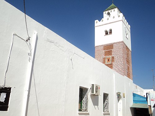
Like the rest of Tunisians, most of the Béjeans are Muslims with a small minority of irreligious. In the past there was a small community of Jews and a bigger one of Christians (most of them were European colons), but after the independence of Tunisia from France, all of them quit the city to Europe, North America and Israel. The city shelters many religion buildings like mosques, churches and synagogues. The oldest mosque of the town is
After the settlement of the
The city, an ancient bishopric, is still listed under its ancient name of Vaga as titular see by the Catholic Church.[8]
-
 The Great Mosque of Béja
 -
 The Bey's Mosque
 -
 The Notre-Dame-du-Rosaire Church


Education
There are 15 elementary schools, 7 preparatory schools, 6 secondary schools and 3 educational institutes in Béja.
Elementary schools
- Victor Hugo Elementary School
- Farhat Hached Elementary School
- Habib Bourguiba Avenue Elementary School
- El-Moustakbel Elementary School
- Sidi Fredj Elementary School
- El-Mahla Elementary School
- Ali El-Kalsadi Elementary School
- Ksar Bardo Elementary School
- Hay Essoker 1 Elementary School
- Hay Essoker 2 Elementary School
- El-Mzara Elementary School
Preparatory schools

- Al-Iadhi Al-Beji Preparatory School
- Ali Al-Qalsadi Preparatory School
- Ibn Al-Jazar Preparatory School
- Habib Bourguiba Avenue Preparatory School
- Rached Preparatory School
- Béja Al*Moustakbel Preparatory School
- Al-Houria Preparatory School
- Ibn-Arafa Preparatory School
Secondary schools

- Ibn Al-Haytham Secondary School
- Ibn Al-Jazzar Secondary School
- March 2, 1934, Secondary School
- Al-Biaa Secondary School
- Ali Belhouane Secondary School
- Omar El Kalchani Secondary School
Institutes
- Higher Institute of Technological Studies of Béja
- Higher Institute of Biotechnology of Béja
- Higher Institute of Applied Languages and Computer of Béja
Historical Places

Kasbah of Béja : The Kasbah of Béja, is a castle built during the Roman area over the ruins of another Carthaginian castle, the Kasbah was destroyed during the Vandal invasion of Tunisia, it was lately rebuilt by the Byzantine Empire and improved and fortified through the years of the Islamic rule, the Kasbah played a major role in protecting the city from various invasion, it's located on the top of the city.
Béja Bardo Palace : Is an ancient royal residence built by the heir of the
The Great Mosque of Béja : The Great Mosque of Béja is one of the oldest mosques of the country, built in 944 by the
Mosque Al-Jazzar is a very old mosque built by Ahmed Al-Jazzar, a Muslim ascetic, during the Aghlabib era in the 10th century.
The Hanafi Mosque : The Hanafi Mosque is a mosque built in Béja in 1675 by
Sidi Boutefeha Mausoleum : Sidi Boutefeha Mausoleum is a mausoleum built in the 17th century in memory to the young Sufi Wali Sidi Sulaymeb Al-Tamimi who was known as Boutefeha (The Father of The Appel).
Sidi Baba Ali Smadhi Mausoleum : Sidi Baba Ali Smadhi Mausoleum is mausoleum built 1666 by the Sufi Marabout Ali Smadhi. The Mausoleum played a major role during the Husainid-Pechist civil war, it's also an important cultural and political center of Béja.
The Qadiriyya Mausoleum : The Qadiriyya Mausoleum is a mausoleum belonging to the
The Khadharin Mausoleum : The Khadharin Mausoleum is another Qadiri Sufi order mausoleum built in 1780 by Ahmed Blagui.
Sidi Salah Zlaoui Mausoleum : Sidi Salah Zlaoui Mausoleum is mausoleum built in the 18th century by Salah Ibn Mohamed Zlaoui who was a very famous Sufist in Béja, the mausoleum was transformed by Jilani Zlaoui, one of Sidi Salah great-grandsons, into a mosque.
Hammam Bousandel : Hammam Bousandel, is a public bath built in the 10th century, the bath is still operative till today.
Sabil Saheb Ettabaâ : Sabil Saheb Ettabaâ is a fountain built by
Notable people
- Amor Chouikha - A scholar in religion and a teacher in Zaytouna. Thé first in front of the owners of Muted Pasha Mosque, the author of many books and works and judge, died in 1972 in Beja.
- Mancient Christian basilicaohamed Arbi Zarrouk Khaznadar – 4th Grand Vizir of Tunisia from 1815 to 1822 (born in Le Bardo but his family is from Béja)
- Ismaïl Fathali – Tunisian Army Chief of Staff
- Wassila Ben Ammar– 2sd Tunisian First Lady from 1962 to 1986
- Ammar Farhat – Famous Tunisian painter
- Slaheddine Ben Mbarek – Former Tunisian minister of National Economy, Commerce, Industry and Agriculture
- The Socialist Party
- Neji Jouini – Former football referee
- Mohamed Ali Yousfi – Writer and translator
- Maurice Audin – Mathematician, member of the Algerian Communist Party and an activist in the anticolonialist cause
- Rafiq Belhaj Kacem – Former minister of the Interior
- Afouène Gharbi – Footballer
- Sofiane Labidi – Sprinter
- Moïne Chaâbani – Footballer
- Mohamed Sayari – Famous Tunisian actor and theatre director
- Chaker Zouagi – Footballer
Gallery


Sister cities
 Beja, Portugal (1993)
 Gibellina, Italy (2012)
External links
- (in French) Site officiel de la municipalité de Béja Archived March 3, 2016, at the Wayback Machine
- (in French) 250 cartes postales anciennes de Béja (1900–1950)
References
- ^ Annelou van Gijn, John Whittaker, Patricia Anderson. Exploring and Explaining Diversity in Agricultural Technology. page 147
- ^ "Les normales climatiques en Tunisie entre 1981 2010" (in French). Ministère du Transport. Archived from the original on December 19, 2019. Retrieved January 25, 2020.
- ^ "Données normales climatiques 1961-1990" (in French). Ministère du Transport. Archived from the original on December 21, 2019. Retrieved January 25, 2020.
- ^ "Les extrêmes climatiques en Tunisie" (in French). Ministère du Transport. Archived from the original on December 21, 2019. Retrieved January 25, 2020.
- ^ "Réseau des stations météorologiques synoptiques de la Tunisie" (in French). Ministère du Transport. Retrieved January 25, 2020.
- ^ "60723: Beja (Tunisia)". ogimet.com. OGIMET. August 10, 2021. Retrieved August 10, 2021.
- ^ "Climate Normals 1991-2020". NOAA.gov. National Oceanic and Atmospheric Administration. Retrieved September 18, 2018.
- ^ Titular Episcopal See of Vaga at GCatholic.org.