
Keweenaw Fault


The Keweenaw Fault is a
Grenvillian orogeny.[2] The Keweenaw Peninsula, itself, is the southeastern side of a large syncline beneath Lake Superior. The northwestern side forms Isle Royale.[3]
The fault is more than 100 miles (160 kilometers) long and extends from the tip of the Keweenaw Peninsula in the northeast to a termination near the Michigan-Wisconsin border in the southeast.
A seismic event in 1906 claimed to be an earthquake has been attributed to a rock burst, as the area has been significantly mined.[6]
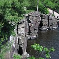
The Natural Wall
-Quartz-21371.jpg)
One significant feature along the Keweenaw Fault is known as the Natural Wall. The Wall is a near-vertical slope of the Jacobsville Sandstone which dips as steeply 85°.[7] The steep dip of the Jacobsville Sandstone is the result of it being folded due to motion on the fault.
Interstate State Park at St. Croix Falls, Wisconsin
is an example of the Keweenaw Fault. On its trails visitors can find Tholeiitic basalts.
-
 Tholeiitic basalts - Clam Falls Volcanics, Mesoproterozoic
 -
 Tholeiitic basalts - Clam Falls Volcanics, Mesoproterozoic
_1_(23443260210).jpg)
_8_(23707446946).jpg)
References
- ^ Brandes, Paul. "Geology of the Keweenaw Peninsula, Michigan". mindat.org. Retrieved March 4, 2012.
- ^ Hodgin, E. B., Swanson-Hysell, N. L., DeGraff, J. M., Kylander-Clark, A. R. C., Schmitz, M. D., Turner, A. C., Zhang, Y., Stolper, D. A. (2022), Final inversion of the Midcontinent Rift during the Rigolet Phase of the Grenvillian Orogeny, Geological Society of America
- ^ Huber, N. King (1975). "The Geologic Story of Isle Royale National Park". United States Geological Survey. Retrieved February 2, 2008.
- ^ Hamblin, W.M. Kenneth (1958). The Cambrian Sandstones of Northern Michigan (PDF) (Report). State of Michigan Department of Conservation. p. 47. Retrieved February 16, 2012.
- ^ Hamblin, W.M. Kenneth (1958). The Cambrian Sandstones of Northern Michigan (PDF) (Report). State of Michigan Department of Conservation. p. 48. Retrieved February 16, 2012.
- ^ McLaren, Noël (August 30, 2011). "Could the Keweenaw Fault become active?". Upper Michigan's Source. Retrieved March 4, 2012.
- ^ Irving, E. D.; Chamberlin, T. C. (1885). "Observations on the Junction Between the Eastern Sandstone and the Keweenwaw Series on Kweweenaw Point, Lake Superior" (PDF). State of Michigan. Retrieved July 21, 2011.
This Michigan state location article is a stub. You can help Wikipedia by expanding it. |