
Jacobsville Sandstone
| Jacobsville Sandstone | |
|---|---|
Jacobsville, Michigan |
Jacobsville Sandstone is a red
The sandstone has been variously called redstone, brownstone, Lake Superior Sandstone, and Eastern Sandstone. In 1907, the Jacobsville Formation was given its current classification and the name Jacobsville, in honor of
Geology
Classification
The earliest geologic studies of southern Lake Superior were made in the early 1800s. Many studies used the term Lake Superior Sandstone to describe a number of different geologic formations.
Similarities in
A red
Description
Jacobsville Sandstone is generally red, due to small quantities of iron oxides, mottled with various pinks, whites and browns.
The sandstone is well-cemented
Extent and stratigraphy


The formation lies southeast of the
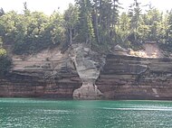
The Jacobsville Formation outcrops significantly throughout the Upper Peninsula, with lesser exposures in Ontario and Wisconsin.[28] Cliffs of the sandstone tend to have blocky talus that supports little vegetation.[29] Jacobsville Sandstone, rising only a few feet above lake level, is the oldest formation exposed in Pictured Rocks National Lakeshore. The sandstone features prominently on Grand Island in Hiawatha National Forest.[25]
Formation and age
Jacobsville Sandstone was deposited within
The Jacobsville Formation was deposited atop rocks of the late
Aquifer
The formation is a mostly
Extraction
The earliest extraction of the sandstone occurred in
One of the principal figures in the Jacobsville Sandstone industry was John Henry Jacobs,[42] to whom the largest producers in the Jacobsville area were associated.[45] The town was founded in 1884 when Jacobs opened his first quarries in the area.[46] Both the sandstone and the town of Jacobsville are named for him.[20]
The two main varieties of Jacobsville Sandstone that were quarried were redstone and brownstone.[47] Redstone came from the Jacobsville area, in both uniform and variegated varieties.[48] A purplish-brown variety of brownstone known as rain-drop, so named for its wet appearance, was described as the "most handsome stone quarried on Lake Superior."[49] Brownstone and rain-drop were supplied from Marquette, however, supplies were generally limited.[48] Until the early 1900s, Jacobsville Sandstone was popularly known as Lake Superior Sandstone, brownstone or redstone and prefixed by the location in which it was quarried, such as Marquette and Portage Entry (e.g., Marquette brownstone).[9]
Technique

The sandstone was quarried as
When a new quarry was opened, up to 50 ft (15 m) of
Decline
| Year | Total value[56] |
|---|---|
| 1899 | $178,038 |
| 1900 | $132,650 |
| 1901 | $174,428 |
| 1902 | $188,073 |
| 1903 | $121,350 |
| 1904 | $74,868 |
| 1905 | $123,123 |
| 1906 | $65,395 |
| 1907 | $53,003 |
| 1908 | $39,103 |
| 1909 | $36,084 |
| 1910 | $31,233 |
| 1911 | $12,985 |
| 1912 | $16,438 |
| 1913 | $19,224 |
| 1914–1916 | — |
The World's Columbian Exposition of 1893 in Chicago, with its White City, ushered in a change of style that preferred light-colored marbles and limestones over the dark color of Jacobsville Sandstone.[57] The direction of architecture was dramatically altered within a decade at the expense of Jacobsville Sandstone, especially in the Lake Superior region.[58] In 1896, the commissioner of mineral statistics for Michigan reported that:
Architects have pronounced against it in their plans and specifications ... for the reason that architecture must have a change of style and material the same as millinery and tailoring. They claimed that too much sandstone was being used, and that the sameness must be broken into by the use of stone of other kind and color ...[53]
The industry began to decline and many quarries idled as previously mined sandstone was sufficient to meet demand.[59] After several years of depressed demand, the industry rebounded around the turn of the century.[47] However, Michigan's total output of sandstone peaked in 1902 at a value of $188,073 and fell to $12,985 by 1911.[56] By 1914, fewer than three companies were producing sandstone in the state and thus no figures were recorded.[56]
According to the director of the
The exact end of the industry is unclear, but most quarries were closed by about 1915.
The town of Jacobsville, founded by the sandstone industry, peaked in population around 1897 at about 800 residents.[46] The town began declining around 1910 and by the mid-1960s, the post office had closed and only seventy inhabitants remained.[65]
Other resources and future
Though Jacobsville Sandstone was primarily used as stone, there exists the potential for other industries. The formation contains a large amount of iron, but there has been little exploration.[66] There has been a history of exploration for uranium resources in the Upper Peninsula, including within the Jacobsville formation.[67][68] Between 2003 and 2010, a joint operation between two companies spent $1.6 million on uranium exploration in the Jacobsville.[69] There has also been some interest in resuming extraction of the sandstone as dimension stone.[70]
The Jacobsville Sandstone has been designated by the International Union of Geological Sciences as a Global Heritage Stone Resource.[71]
Uses


Material qualities
Jacobsville Sandstone was popular as a building material because of its strength, durability and aesthetic appeal. In particular, it is resistant to the extremes in temperature of fire and the
Its fire-proof qualities were thoroughly tested in the great Chicago fire, where Lake Superior brownstone walls ... stood intact, without a crack, scale or blemish being caused by the great heat under the influence of which marble fronts crumbled and fell to the ground.[73]
The sandstone was inexpensively obtainable in large quantities and transport by the Great Lakes further reduced costs. It is also easily worked and carved, and could be used throughout a building.[40] The most desired stone was without white blemishes and with uniform coloring.[52] The Richardsonian Romanesque style, which is "particularly suited for expression in colored stone", helped to popularize the sandstone in architecture.[59] Buildings of this style created the impression of stability in a fast-changing society and were well-suited to the character of the Lake Superior region.[74]
Buildings and structures
Several buildings in the Upper Peninsula
The rubble stone was commonly used for foundations, cribs, breakwaters and piers.[51]
Jacobsville Sandstone has been used as concrete aggregate[48] and flagstone.[80]
See also
References
- ^ a b c Hodgin, E. B., Swanson-Hysell, N. L., DeGraff, J. M., Kylander-Clark, A. R. C., Schmitz, M. D., Turner, A. C., Zhang, Y., Stolper, D. A. (2022), Final inversion of the Midcontinent Rift during the Rigolet Phase of the Grenvillian Orogeny, Geological Society of America
- ^ Hamblin 1958a, p. 5
- ^ a b c "The Jacobsville Formation and Associated Units in Ontario" (PDF). Ontario Ministry of Northern Development and Mines. February 12, 1987. Archived (PDF) from the original on July 31, 2012. Retrieved February 16, 2012.
- ^ Hamblin 1958a, pp. 5–6
- ^ a b Hamblin 1958a, p. 6
- S2CID 128743929.
- ^ a b c Hamblin 1958a, p. 9
- ^ Hamblin 1958a, p. 7
- ^ a b c d Eckert 2000, p. 33
- ^ a b Baumann 2010, p. 6
- ^ Bulletin, Issue 25. Wisconsin Geological and Natural History Survey. 1912. p. 104.
- ^ Ostrom, Meredith E. "Paleozoic Stratigraphic Nomenclature For Wisconsin" (PDF). Information Circular Number 8. The University of Wisconsin Geological and Natural History Survey. Archived from the original (PDF) on April 24, 2012. Retrieved April 5, 2012.
- ^ hdl:1811/23429. Archived(PDF) from the original on March 4, 2016. Retrieved May 4, 2012.
- ^ a b c d Eckert 2000, p. 34
- ^ Hamblin 1958a, pp. 11–12
- ^ James St. John. "Jacobsville sandstone". Ohio State University. Archived from the original on September 25, 2012. Retrieved September 22, 2012.
- ^ a b c d Olcott, Perry G. "Jacobsville and Crystalline-Rock Aquifers". Ground Water Atlas of the United States: Iowa, Michigan, Minnesota, Wisconsin. United States Geological Survey. Archived from the original on September 28, 2010. Retrieved August 12, 2011.
- ^ Hamblin 1958a, pp. 12–19
- ^ a b Baumann 2010, p. 5
- ^ a b Eckert 2000, p. 31
- ^ Atkinson et al. 2007, p. 11
- ^ Wood et al. 1982, p. 113
- ^ Olcott, Perry G. "Regional Summary". Ground Water Atlas of the United States: Iowa, Michigan, Minnesota, Wisconsin. United States Geological Survey. Archived from the original on September 27, 2010. Retrieved April 22, 2012.
- ^ Hamblin 1958a, pp. 9–10
- ^ a b c "Pictured Rocks: Geologic Formations". US National Park Service. Archived from the original on September 25, 2010. Retrieved August 5, 2011.
- ^ "Digital Bedrock Geologic Map of the Ashland and Northern Part of the Ironwood 30' x 60' Quadrangles, Wisconsin and Michigan: Background" (PDF). United States Geological Survey. 1999. p. 3. Archived (PDF) from the original on September 25, 2012. Retrieved June 8, 2012.
- ^ Atkinson et al. 2007, p. 12
- ^ Baumann 2010, p. 3
- ^ "Sandstone Lakeshore Cliff" (PDF). Michigan Natural Features Inventory. Michigan State University. p. 5. Archived (PDF) from the original on September 22, 2012. Retrieved April 21, 2012.
- ^ Sherman et al. 2003, p. 2
- ^ Rose 1997, p. 1
- ^ Mitchell, R. L., Sheldon, N. D. (2010), The ~1100Ma Sturgeon Falls paleosol revisited: Implications for Mesoproterozoic weathering environments and atmospheric CO2 levels, Elsevier BV
- ^ Hamblin 1958b, p. 24
- ^ "Sandstone aquifers". Groundwater Atlas of the United States. USGS. Archived from the original on March 9, 2012. Retrieved 30 November 2014.
- ^ "List of Aquifers" (PDF). Advisory Committee on Water Information. Archived (PDF) from the original on September 28, 2012. Retrieved October 30, 2011.
- ^ Vanlier, Kenneth E. (1963). "Water Investigation 1: Reconnaissance of the Ground-Water Resources of Alger County, Michigan" (PDF). Michigan Department of Environmental Quality. p. 11. Archived (PDF) from the original on October 17, 2012. Retrieved August 31, 2011.
- ^ Sherman et al. 2003, p. 10
- ^ Hauglie, Kurt (October 18, 2010). "Taking a dangerous breath". The Daily Mining Gazette. Archived from the original on October 5, 2013. Retrieved April 29, 2012.
- ^ H. James Bourque and Associates 1999, p. 49
- ^ a b Eckert 2000, p. 49
- ^ Eckert 2000, p. 50
- ^ a b c H. James Bourque and Associates 1999, p. 5
- ^ Eckert 2000, p. 51
- ^ H. James Bourque and Associates 1999, p. 56
- ^ Eckert 2000, p. 70
- ^ a b c Staff. "Jacobsville Finnish Lutheran Church". State Historic Preservation Office. Michigan State Housing Development Authority. Archived from the original on September 22, 2012. Retrieved February 19, 2011.
- ^ a b Russel, James (1900). State of Michigan: Mines and Mineral Statistics (PDF) (Report). State of Michigan. p. 11. Archived (PDF) from the original on December 31, 2010. Retrieved April 5, 2012.
- ^ a b c d e Heinrich, E. William (2001). Report of Investigation 21: Economic Geology of the Sand and Sandstone Resources of Michigan (PDF) (Report). Michigan Department of Environmental Quality, Geological Survey Division. p. 7. Archived (PDF) from the original on December 31, 2010. Retrieved November 4, 2011.
- ^ Eckert 2000, p. 54
- ^ Eckert 2000, p. 40
- ^ a b Eckert 2000, p. 41
- ^ a b c Eckert 2000, p. 42
- ^ a b c Newett, George A. (1896). State of Michigan: Mines and Mineral Statistics (PDF) (Report). State of Michigan. p. 78. Archived (PDF) from the original on October 24, 2012. Retrieved April 4, 2012.
- ^ Eckert 2000, p. 43
- ^ Eckert 2000, p. 45
- ^ a b c Mineral resources of Michigan with statistical tables of production and value of mineral products for 1916 and prior years (Report). Michigan Geological Survey, United States Bureau of Mines. 1917. p. 191.
- ^ Eckert 2000, p. 28
- ^ Eckert 2000, pp. 27–28
- ^ a b c d Eckert 2000, p. 86
- ^ Eckert 2000, p. 87
- ^ a b Newett, George A. (1897). State of Michigan: Mines and Mineral Statistics (PDF) (Report). State of Michigan. p. 78. Archived (PDF) from the original on December 31, 2010. Retrieved May 3, 2012.
- ^ Staff. "Wayne County Courthouse". State Historic Preservation Office. Michigan State Housing Development Authority. Archived from the original on September 22, 2012. Retrieved May 3, 2012.
- ^ Eckert 2000, pp. 28–29
- ^ Eckert 2000, p. 29
- ISBN 978-0-8143-2974-0.
- ^ Baumann 2010, p. 2
- ^ Sherman, Heidi M. (2004). "Hydrogeochemcial Controls on Uranium in Aquifers of the Jacobsville Sandstone" (PDF). Michigan Technological University. p. 14. Archived from the original on September 22, 2015. Retrieved April 24, 2012.
- ^ Staff (March 31, 1982). Uranium in Michigan: Report to the Governor (PDF) (Report). Michigan Department of Natural Resources and Department of Public Health. pp. 20–22. Archived (PDF) from the original on December 31, 2010. Retrieved April 23, 2012.
- ^ "Upper Peninsula Uranium Exploration Overview". Bitterroot Resources Ltd. January 8, 2010. Archived from the original on March 28, 2010. Retrieved April 24, 2012.
- ^ H. James Bourque and Associates 1999, p. 6
- ^ "Designation of GHSR". IUGS Subcommission: Heritage Stones. Retrieved 24 February 2019.
- ^ Eckert 2000, p. 48
- ^ Eckert 2000, pp. 49–50
- ^ Eckert 2000, p. 27
- ^ "Rock Types and Rock Structure of the UP". Michigan State University. Archived from the original on December 28, 2010. Retrieved August 12, 2011.
- ^ Dunlop, Joan (12 May 1991). "Pines, mines, llamas and pasties on Michigan's Keweenaw Peninsula". Chicago Sun-Times. Archived from the original on 6 November 2012. Retrieved August 12, 2011.
- ^ Staff. "Saint Ignatius Loyola Church". State Historic Preservation Office. Michigan State Housing Development Authority. Archived from the original on September 22, 2012. Retrieved August 21, 2011.
- ^ Staff. "Quincy Street Historic District". State Historic Preservation Office. Michigan State Housing Development Authority. Archived from the original on June 6, 2011. Retrieved August 12, 2011.
- ^ Ruth Fletcher (10 June 2013). "Like a rock - sandstone had solid role in area's architecture". Sault Star. Retrieved 15 November 2023.
- ^ Kirkby, Edward A. (1964). "Michigan Sandstones". Bulletin 1: Our rock riches: a selected collection of reprinted articles on Michigan's mineral resources (PDF) (Report). State of Michigan, Department of Conservation, Geological Survey. p. 36. Archived (PDF) from the original on December 31, 2010. Retrieved February 16, 2015.
Bibliography
- Atkinson, B. T.; Hailstone, M.; Wilson, A. C.; Draper, D. M.; Pace, A.; Woo, H. (2007). Timmins Regional Resident Geologist Report: Timmins and Sault Ste. Marie Districts (PDF) (Report). Ontario Geological Survey. Archived (PDF) from the original on August 31, 2017. Retrieved August 1, 2012.
- Baumann, Steven D.J. (2010). Lithostratigraphy and Age of Jacobsville Formation around the Lake Superior Basin, U.S.A. and Canada (PDF) (Report). Midwest Institute of Geosciences and Engineering. Archived from the original (PDF) on October 9, 2013. Retrieved February 19, 2012.
- Eckert, Kathryn Bishop (2000). The sandstone architecture of the Lake Superior region. Wayne State University Press. ISBN 978-0-8143-2807-1.
- H. James Bourque and Associates (July 1, 1999). "Dimension Stone Feasibility Study" (PDF). Michigan Department of Environmental Quality. Archived (PDF) from the original on September 22, 2012. Retrieved August 28, 2011.
- Hamblin, W. M. Kenneth (1958a). The Cambrian Sandstones of Northern Michigan (PDF) (Report). State of Michigan Department of Conservation, Geological Survey Division. pp. 2–18. Archived (PDF) from the original on December 24, 2011. Retrieved February 16, 2012.
- Hamblin, W. M. Kenneth (1958b). The Cambrian Sandstones of Northern Michigan (PDF) (Report). State of Michigan Department of Conservation, Geological Survey Division. pp. 19–37. Archived (PDF) from the original on December 24, 2011. Retrieved February 16, 2012.
- Hamblin, W. M. Kenneth (1958c). The Cambrian Sandstones of Northern Michigan (PDF) (Report). State of Michigan Department of Conservation, Geological Survey Division. pp. 38–55. Archived (PDF) from the original on September 22, 2012. Retrieved February 16, 2012.
- Rose, Robert (1997). Overview of Cambrian Sandstone Environments of Deposition (PDF). Pictured Rocks National Lakeshore Resource Report (Report). US National Park Service. Archived (PDF) from the original on October 6, 2017. Retrieved July 11, 2012.
- Sherman, Heidi M.; Taylor, Peter; Gierke, John S.; Anderson, Cecilia P. (2003). Elevated Uranium in Aquifers of the Jacobsville Sandstone, Upper Peninsula, Michigan, USA (PDF) (Report). National Ground Water Association. p. 11. Archived from the original (PDF) on 2012-04-24. Retrieved April 23, 2012.
- Wood, John; White, Owen L.; Barlow, R. B.; Colvine, A. C. (1982). Summary of Field Work, 1982 (PDF) (Report). Ontario Geological Survey. Archived (PDF) from the original on September 22, 2012. Retrieved August 1, 2012.
External links
- Map showing extent of Jacobsville Sandstone in Ontario,[dead link] from the Ontario Ministry of Northern Development and Mines
- Quarry images Archived 2017-08-31 at the Wayback Machine at cityofhoughton.com
- Portage Houghton Quarry
| Ph |
| ||||||||||||||||||||||||||||||||||||||||||||||||||
|---|---|---|---|---|---|---|---|---|---|---|---|---|---|---|---|---|---|---|---|---|---|---|---|---|---|---|---|---|---|---|---|---|---|---|---|---|---|---|---|---|---|---|---|---|---|---|---|---|---|---|---|
| Є |
| ||||||||||||||||||||||||||||||||||||||||||||||||||
| ♇ |
|---|