
Kollnburg
Kollnburg | |
|---|---|
 Town hall | |
 Coat of arms | |
Location of Kollnburg within Regen district 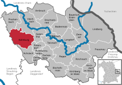 | |
Niederbayern | |
| District | Regen |
| Government | |
| • Mayor (2020–26) | Herbert Preuß[1] (FW) |
| Area | |
| • Total | 59.52 km2 (22.98 sq mi) |
| Elevation | 655 m (2,149 ft) |
| Population (2022-12-31)[2] | |
| • Total | 2,802 |
| • Density | 47/km2 (120/sq mi) |
| Time zone | UTC+01:00 (CET) |
| • Summer (DST) | UTC+02:00 (CEST) |
| Postal codes | 94262 |
| Dialling codes | 09942 |
| Vehicle registration | REG |
| Website | www.kollnburg.de |
Kollnburg is a municipality in the district of Regen, in Bavaria, Germany. A part of the municipal area, including the parish village of the same name, is a state-approved resort.
Geography
The community is located in the Donau Forest region in the middle of the Bavarian Forest north of the 1050 m high Proeller between Viechtach (five kilometers) and Sankt Englmar (six kilometers). The two towns of Bogen and Regen are each 27 km away, while Deggendorf and Cham are each 31 km away.
History
Community Planting
The local history is closely connected to its fortress Burgruine Kollnburg, which was first mentioned in 1153 as Chalnberch. It was still called Kalmperg in 1685, while Bernhard Grueber and Adalbert Müller called it Kohlenburg in their book Der Bavarian Forest, published in 1846. In the "Contributions to the Statistics of the Kingdom of Bavaria" the place is already referred to as Kollnburg in issue XXI from 1869.
Kollnburg belonged to the Barons von Kastner. The place was part of the Electorate of Bavaria, but formed a closed Hofmark, whose seat was Kollnburg. In the course of the administrative reforms in Bavaria, today's municipality came into being with the municipal edict.
Incorporation
In the course of the regional reform in Bavaria, the municipality of Rechertsried was incorporated on October 1, 1971, and the municipalities of Allersdorf and Kirchaitnach on May 1, 1978, incorporated into the municipality of Kollnburg.
Population Development
Between 1988 and 2018, the population stagnated or fell minimally from 2800 to 2795 by 5 inhabitants or 0.2%.
- 1867: 1027 inhabitants
- 1871: 1060 inhabitants
- 1961: 2764 inhabitants
- 1970: 2695 inhabitants
- 1987: 2786 inhabitants
- 1991: 2838 inhabitants
- 1995: 2905 inhabitants
- 2000: 2970 inhabitants
- 2005: 2891 inhabitants
- 2010: 2894 inhabitants
- 2015: 2787 inhabitants
Politics
Municipal Council
Since the municipal elections in Bavaria 2014, the municipal council has been composed as follows:[3]
- CSU: 4 seats (33.42% of the votes)
- FW: 5 seats (35.09% of the votes)
- Bürger für Kollnburg: 3 seats (18.76% of the votes)
- GPÖ: 2 seats (12.73% of the votes)
Mayor
Herbert Preuß (FW) has been the first mayor since May 1, 2020. In the municipal elections in Bavaria 2020, he won the run-off election on March 29, 2020, with 55.1 percent against the previous incumbent Josefa Schmid, who has been the first mayor of Kollnburg since 2008.
Coat of Arms
The municipal
Architectural and archaeological monuments
- Burgruine Kollnburg: Castle ruins with round tower and castle fountain
- Burgstall Kollnburg
Statistics
In 1998, according to official statistics, 10 employees in agriculture and forestry, 136 in manufacturing and 17 in trade and transport had an insurable employment. In other sectors of the economy, 137 people had an insurable employment. There were a total of 895 employees in insurable employment. There were no manufacturing companies, and 6 companies in main construction trades. In addition, in 1999 there were 181 farms with an agricultural area of 2735 ha, of which 2178 ha were permanent grasslands.
Economy and infrastructure
Tourism
The districts of Kollnburg, Bach, Baierweg, Gnad, Hochstrass, Höfen, Hornhof, Kagermühle, Karglhof, Marktbuchen, Oed, Ogleinsmais, Reichsdorf, Reisach, Sattel, Schreinermühle, Steffelhof, Tafertshof, Unterdornach, Waldhof, Weggütl, Wieshof, and Windsprach are state-recognized as resorts.
Education
There are the following institutions (status: 1999):
- Kindergarten with 75 kindergarten places and 67 children
- A primary school with 5 classes and 8 teachers in the center of Kollnburg
Personalities
- Josef Biebl (* 1959), labor lawyer and judge at the Federal Labour Court
- Florian Pledl (* 1984), accordionist of Da Rocka & da Waitler
External links
References
- Bayerisches Landesamt für Statistik, 15 July 2021.
- ^ Genesis Online-Datenbank des Bayerischen Landesamtes für Statistik Tabelle 12411-003r Fortschreibung des Bevölkerungsstandes: Gemeinden, Stichtag (Einwohnerzahlen auf Grundlage des Zensus 2011).
- ^ wahl. info – candidates & results