
Kowloon
Kowloon
九龍 | |
|---|---|
UTC+8 (Hong Kong Time ) |
| Kowloon | ||
|---|---|---|
.svg) "Kowloon" in Traditional (top) and Simplified (bottom) Chinese characters | ||
| Traditional Chinese | 九龍 | |
| Simplified Chinese | 九龙 | |
| Jyutping | gau2 lung4 | |
| Literal meaning | "Nine Hanyu Pinyin Jǐulóng | |
| Bopomofo | ㄐㄧㄡˇ ㄌㄨㄥˊ | |
| Wade–Giles | Chiu3-lung2 | |
| Tongyong Pinyin | Jiǒulóng | |
| IPA | [tɕjòʊ.lʊ̌ŋ] | |
| Hakka | ||
| Romanization | giu3lung2 | |
| Yue: Cantonese | ||
| Yale Romanization | Gáulùhng | |
| Jyutping | gau2 lung4 | |
| IPA | [kɐu˧˥ loŋ˩] | |
Kowloon (/ˌkaʊˈluːn/) is an urban area in Hong Kong comprising the Kowloon Peninsula and New Kowloon. It has a population of 2,019,533 and a population density of 43,033/km2 (111,450/sq mi) in 2006. It is one of the three regions of Hong Kong, along with Hong Kong Island and the New Territories, and is the smallest and most densely populated.
Location
Kowloon is located directly north of Hong Kong Island across Victoria Harbour. It is bordered by the Lei Yue Mun strait to the east, Mei Foo Sun Chuen, Butterfly Valley and Stonecutter's Island to the west, a mountain range, including Tate's Cairn and Lion Rock to the north, and Victoria Harbour to the south. Also, there are many islands scattered around Kowloon, such as CAF island.
Administration
Kowloon comprises the following districts:
Name
The name 'Kowloon' (
History


The part of Kowloon south of
Statutorily, "Kowloon" is only the area south of Boundary Street and Stonecutters Island, but in common use, New Kowloon is not regarded as part of the New Territories, but as an integral part of the Kowloon urban area whether north or south of Boundary Street.
Large-scale development of Kowloon began in the early 20th century, with the construction of the
The area of
The 1911 census recorded a population of 7,306, with most being
Demographics
As of 2011[update], 2,108,419 people lived in Kowloon.[6]
About 94.2% of Kowloon's residents are of
Localities
Kowloon comprises these localities of Hong Kong:
- Anderson Road area
- Austin
- Cha Kwo Ling
- Cheung Sha Wan
- Diamond Hill
- Jordan
- Hammer Hill
- Hung Hom
- Ho Man Tin
- Kai Tak
- Kowloon Bay
- Kowloon City
- Kowloon Tong
- Kwun Tong
- Lai Chi Kok
- Lam Tin
- Lei Yue Mun
- Ma Tau Wai
- Mong Kok
- Ngau Chi Wan
- Ngau Tau Kok
- Prince Edward
- San Po Kong
- Sau Mau Ping
- Sham Shui Po
- Shek Kip Mei
- Tai Kok Tsui
- To Kwa Wan
- Tsim Sha Tsui
- Tsz Wan Shan
- West Kowloon
- Wong Tai Sin
- Yau Ma Tei
- Yau Tong
Education

Lists of primary and secondary schools in Kowloon by district:
- List of schools in Kowloon City District
- List of schools in Kwun Tong District
- List of schools in Sham Shui Po District
- List of schools in Wong Tai Sin District
- List of schools in Yau Tsim Mong District
Tertiary education
- City University of Hong Kong
- Hong Kong Polytechnic University
- Hong Kong Baptist University
- Open University of Hong Kong
- Tung Wah College
- Hong Kong Nang Yan College of Higher Education
- Gratia Christian College
Notable people
- Sean Parry (born 1987), cricketer
- Jackson Wang (born 1994), Founder of TEAM WANG, rapper, singer, dancer, record producer, fashion designer, and music video director
Transport

Kowloon is connected to Hong Kong Island by two road-only
Gallery
This section contains an unencyclopedic or excessive gallery of images. |
-
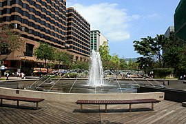 Urban Council Centenary Garden fountain, Tsim Sha Tsui
 -
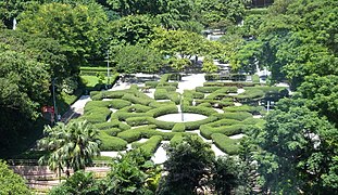 Maze Garden, Kowloon Park, Tsim Sha Tsui
 -
 An Air France Boeing 747 passing above Kowloon, prior to landing at the old airport in 1998.
 -
 Star Ferry Pier, with the Hong Kong Cultural Centre and Tsim Sha Tsui Clock Tower in the background.
 -

-
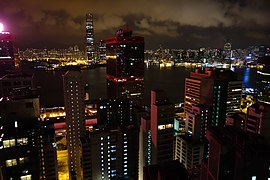 Night view of Kowloon from Hong Kong Island


References
- ^ ISBN 981-258-246-0
- ^ "KAWLOONG FERRY STATION: Hong Kong postcard (C48147)". eBay.
- ]
- ISBN 9888139118
- ^ "Hong Kong 2003 – History". www.yearbook.gov.hk. Archived from the original on 26 September 2011. Retrieved 28 April 2018.
- ^ Hong Kong Census, 2011, archivedfrom the original on 27 September 2013, retrieved 27 September 2013
External links
 Media related to Kowloon at Wikimedia Commons
- Media related to Kowloon West at Wikimedia Commons
| Hong Kong Island | |
|---|---|
| Kowloon and New Kowloon | |
| New Territories (excluding New Kowloon) | |
| International | |
|---|---|
| National | |