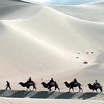
Kumtag Desert

The Kumtag Desert (Chinese: 库姆塔格沙漠; pinyin: Kùmǔtǎgé Shāmò, "kum-tag" meaning "sand-mountain" in a number of Turkic languages), is an arid landform in Northwestern China, which was proclaimed as a national park in the year 2002.
Definitions
Broad
The oval Tarim Basin with its central Taklamakan Desert is bounded on the north, west, and south by mountains. On the east side the Kumtag is an unbroken plain about 100 miles from north to south that runs from the Taklamakan to Gansu province and Mongolia. Many modern maps do not show a Kumtag in this sense, which implies that the usage may be out of date.
The Kumtag Desert is a section of the
Administratively, the desert is located in the
.Narrow
A map published by the National Geographic Society
Ongoing desertification
The Kumtag Desert is expanding and threatening to engulf previously productive lands with its arid wasteland character.[3] Several years prior the estimated size of the desert was 2500 square kilometres, but with recent expansion, the Kumtag Desert is already considerably larger as of 2008.
The Kumtag Desert is continuing a process of expansion that is the result of centuries of
Prevailing winds and sands
The prevailing winds in this region would appear to blow from the west and northwest during the summer, winter and autumn. Though in spring, when they certainly are more violent, they no doubt come from the northeast, as in the desert of Lop. The arrangement of the sand here agrees perfectly with the law laid down by

"At the points where we measured them the northern terrace was 113 feet (34 m) high and the southern 853/4 feet....Both terraces belong to the same level, and would appear to correspond to the shore lines of a big bay of the last surviving remnant of the Central Asian Mediterranean. At the point where I crossed it the depression was 6 to 7 miles (11 km), wide, and thus resembled a flat valley or immense river-bed."[1][5]
The moving sands of the Kumtag are of a concern for the designers of the
See also
References
- ^ a b One or more of the preceding sentences incorporates text from a publication now in the public domain: Bealby, John Thomas (1911). "Gobi, s.v. Desert of Kum-Tagh". In Chisholm, Hugh (ed.). Encyclopædia Britannica. Vol. 12 (11th ed.). Cambridge University Press. p. 166.
- ^ National Geographic Atlas of China',2008, page 29
- ^ a b c Ancient Chinese town on front lines of desertification battle, AFP, Nov 20, 2007
- ^ C.Michael Hogan, Silk Road, North China, The Megalithic Portal, ed. A. Burnham
- ^ Sven Hedlin, Scientific Results, ii, 499–500.
- ^ Study on the Feasibility of Dunhuang-Golmud Railway Crossing the Megadunes Area at the East Edge of Kumtagh Desert Archived 2013-08-01 at the Wayback Machine, Cold and Arid Regions Environmental and Engineering Research Institute, Chinese Academy of Sciences (CAREERI, CAS)
