
La Creusille Harbor
| La Creusille Harbor | |
|---|---|
 Traditional boat of Blois | |
 Click on the map for a fullscreen view | |
| Location | |
| Country | France |
| Location | Centre-Val de Loire, Loir-et-Cher, Blois |
| Coordinates | 47°35′13″N 1°20′42″E / 47.58689°N 1.34495°E |
| Details | |
| Opened | 17st century |
La Creusille is a harbor on the left bank of the Loire river, located in the southern part of Blois, France.
Meaning
The word Creusille (French pronunciation: [kʁøzij]) is an old local dialect term to designate the “hollow pilgrim's scallop” (« creuse coquille du pèlerin » in French[1]). This refers to the shell of Saint James Christian pilgrims used to wear when going to Santiago de Compostela, Spain.[2]
History
Since the
During the Middle Ages, the river is rather different than today. Indeed, the medieval bridge was covered with houses, towers, and even a chapel. To feed 5 water mills, a 650m-long submersible dike was built in the middle of the river around the 9th century (at the latest).[4]
Until 1606, both banks of the river were not parts of the same city, Blois. Indeed, the city was originally set up on the right bank. On the other side, this was actually a river island with a different manor that was under the Catholic Church's administration through St Saturnin parish. The island was named Insula Evenna, and the village standing there Vienne. As such, La Creusille has always been part of Vienne. Until this moment, Blois had its own harbor but it was abandoned after the addition of Vienne.[5]
From the 17th century on,
, and the hotel business flourished, and their growth exceeded the capacity of the shoreline. Thus, a lean port with two access ramps to the shore was developed.After the fall of the medieval bridge in 1716, the port was reinforced as part of the reconstructions of the Loire levees and the construction of the new Jacques-Gabriel Bridge. All the remaining water mills were destroyed, but the submersible dike was readjusted in order to divert the river's flow to the right bank and thus away from La Creusille, making it easier to moor boats. In 1717, a dike was built in the extension of the harbor and towards the East: the operation dried up the La Bouillie river channel and thus linked the former Evenna island to the left bank.[6]
The arrival of the
At the same time, a new activity appeared in the 19th century: sand mining. Miners extracted sand and gravel directly from the steam bed of the Loire river, but the practice was sufficiently important to lower the water line, lower the alluvial water table, dry out wetlands and cause pike spawning grounds to disappear. Mining in Blois was therefore naturally abolished in 1995.[8]
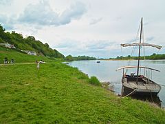
Traditional boats
-
-
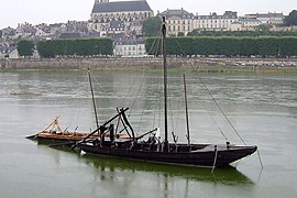 Fustereau in La Creusille Harbor
 -


Today's La Creusille
Since the year 2000, La Creusille is part of the UNESCO's World Heritage sites in France.[9]
Today, the port has given way to an urban park on the left bank of the Loire river, complete with a leisure area. Accessible by car, the park has a parking area, a playground, picnic areas, a ping-pong table, a self-service library and a boulodrome, and provides free access to drinking water and electricity.[10]
The park is located on the route of La Loire à vélo and the European Rivers Route (EV6).[11]
Since 2010, a guinguette animates the park in summer.[12]
La Creusille also hosts the Loire Observatory, which offers traditional boat trips on the river.[13]
References
- ISBN 2842653122..
- ISBN 978-0-900-58888-4.
- ^ On the Blois City Official Website (2022). "La Creusille Harbour". blois.fr.
- ^ Institut National de Recherches Archéologiques Préventives (INRAP) (2014). Archéologie en Région Centre : Vivre au bord de l'eau à Blois (in French).
- ^ Institut National de Recherches Archéologiques Préventives (INRAP) (2014). Archéologie en Région Centre : Vivre au bord de l'eau à Blois (in French).
- ^ Georges Touchard-Lafosse (2011). Histoire de Blois et de son territoire, depuis les temps les plus reculés jusqu'à nos jours (in French).
- ^ Noëlle Lizé, Emmanuelle Plumet and Johanne Quéméré (2017). Focus sur Blois : quartier Vienne (PDF) (in French).
- ^ Noëlle Lizé, Emmanuelle Plumet and Johanne Quéméré (2017). Focus sur Blois : quartier Vienne (PDF) (in French).
- ^ On the Blois City Official Website (2022). "La Creusille Harbour". blois.fr.
- ^ On the Blois City Official Website (2022). "La Creusille Harbour". blois.fr.
- ^ On the Blois City Official Website (2022). "La Creusille Harbour". blois.fr.
- ^ On the Blois City Official Website (2022). "La Creusille Harbour". blois.fr.
- ^ On the Blois City Official Website (2022). "La Creusille Harbour". blois.fr.