
Lake Shasta Caverns
| Lake Shasta Caverns | |
|---|---|
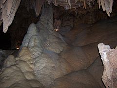
 A merged stalactite and stalagmite in the Lake Shasta Caverns. | |
 Location in California  Location in United States | |
| Location | Shasta County, California |
| Coordinates | 40°48′16″N 122°18′16″W / 40.8045°N 122.30444°W |
| Area | 37 acres (15 ha) |
| Website | Official website |
| Designated | 2012 |
The Lake Shasta Caverns are a network of caves located near the McCloud arm of Shasta Lake in California. It was formerly named Chalk Cave and Baird Cave, named after Spencer Fullerton Baird.
History
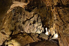
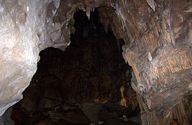
The caverns are dated to at least 200 million years, and were formed by flowing water. Over the years this water drained leaving the caverns seen today. The caves are made entirely of limestone and feature a wide variety of formations, including stalactites, stalagmites, soda straws, columns, and flowstone. The Discovery Room, one of eight known rooms in the cavern system, contains all types of limestone rock formation. The first recorded explorer was James A. Richardson, a federal fisheries employee. His claim of discovery is still clearly legible on the wall where he wrote it that day – November 11, 1878 – with carbide from his miner's lamp.
Until 1964, Lake Shasta Caverns were seen each year by only a handful of hardy
The Lake Shasta Caverns currently attract thousands of visitors every year. The only transportation to the caverns from the visitor center is a short ride on a catamaran across Shasta Lake, followed by a scenic bus ride up a steep mountain grade. The bus ride terminates at the cavern entrance.
Gallery
-
-

-
-

-

-

-
-
 The boat that goes across Shasta Lake to Shasta Caverns.
 -
 The mountain visible as you walk down to the visitor center from the cave exit.


References
- ^ "Lake Shasta Caverns National Natural Landmark". National Park Service. Retrieved 2013-02-22.
External links
- Official site.
- Lake Shasta Caverns. Mr Ryono's Physics and Geology pages