
Langkofel Group
| Langkofel Group | |
|---|---|
 The Langkofel Group against the evening skies. | |
| Highest point | |
| Peak | Langkofel |
| Elevation | 3,181 m s.l.m. |
| Geography | |
 | |
| State | Trentino-Südtirol, Italy |
| Range coordinates | 46°31′29″N 11°44′07″E / 46.52472°N 11.73528°E |
| Parent range | Dolomites |
The Langkofel Group (
Geology
The region was formed in the early Triassic period (about 230 million years ago) as a coral reef in a shallow tropical sea. Hard limestone was able to form on the outside of the reef, whilst the rock in the interior remained brittle and was quickly eroded away following the uplifting of the range. This left a garland of mountains which, in a clockwise direction, are the Langkofel, Langkofeleck, Fünffingerspitze, Grohmannspitze, Innerkoflerturm, Zahnkofel and Plattkofel.
Summits
- Grohmannspitze (Italian: Punta Grohmann, Sasso Levante, Ladin: Sas da duman)
- Innerkoflerturm
- Zahnkofel (Il Dente/l Dënt)
- Langkofelkarspitze
- Plattkofel (Sasso Piatto/Sasplat)
- Fünffingerspitze (Punta Cinquedita)
- Langkofel (Sasso Lungo/Saslonch)
-
 Langkofel Group, labelled
 -
 Aerial photograph of the Langkofel Group
 -
 The group seen from the Plans de Cunfin
 -
 The Langkofel Group from the Sella pass
 -
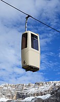 Gondola of the Telecabin Forcella del Sassolungo
.jpg)


Alpine huts
- Langkofel Hut (2256 m, also Rifugio Vicenza, in the Langkofel Cirque (Langkofelkar))
- Emilio Comici Hut (2153 m, private, at the foot of the Langkofel)
- Toni Demetz Hut (2685 m, private, in the Langkofel Col (Langkofelscharte))
- Friedrich August Hut (2298 m, private, on the Friedrich August Way from Sellajoch to the Plattkofel Hut)
- Des Alpes Hut (2395 m, private, on the Rodella Col, cable car from Campitello di Fassa)
- Sandro Pertini Hut (2300 m, private, on the Frederick Augustus Way (Friedrich-August-Weg))
- Plattkofel Hut (2300 m, private, west of the Plattkofel)
- Schutzhaus Sellajoch (2180 m, private, on the road to the Sellajoch below the top of the pass)
- Williams Hut (2100 m, private, at the foot of the Plattkofel)
Tourism
In Summer a
In winter there are ski areas at the foot of the Langkofel Group: the Col Rodella (on the Sellajoch), Plan de Gralba, Ciampinoi (with its well-known Saslong world cup run) and Monte Pana/Mont de Sëura. The famous Sella Ronda, a circuit of the Sella Group on ski pistes both clockwise and anticlockwise, also runs over these pistes.

External links
| International | |
|---|---|
| National | |