
Lizza di Piastreta
| Lizza di Piastreta | |
|---|---|
 View of the track | |
| Overview | |
| Locale | |
| Termini |
|
| Stations | none (5 zones crossed) |
| Service | |
| Type | Monorail |
| History | |
| Opened | 1922 |
| Closed | 1975 |
| Technical | |
| Line length | 3.5 km (2.2 mi) |

The Lizza di Piastreta, also known as Monorotaia di Piastreta ("Piastreta Monorail"), was an Italian industrial monorail serving the marble quarry of Piastreta, in the Apuan Alps, and linking it to Renara, in the municipal territory of Massa, Tuscany.[1]
History
The monorail was projected in 1922 by the English engineer Charles Denham, owner of the quarry of Piastreta.[1] The line, used to carry the marble from the quarry to the valley, consisted of a single rail on wooden sleepers, on which a motorized tractor hauled a sled load. The system of the sleds was already used, for the transport of marble, also in other vie di lizza (i.e. "routes of contention"),[2] on other trials used for the lizzatura.[3] This was the only plant of its kind to be built, and the track was realized in the workshops of Sesto San Giovanni, near Milan.[4]
In 1959 the course was shortened to Pianel Soprano, closing the route to Renara. Reopened in 1962, the line was active until 1975, when a road for trucks was opened.
The line is still intact, except for some portions disappeared due to erosion. The line, also named Lizza della Monorotaia or Monorotaia Denham,[5] is part of a route of industrial archaeology and, since 2003, like many lizze in the basin of Massa, it is included in the Archaeological Park of the Apuan Alps.[4]
Route
The monorail starts in the quarries of Piastreta (1,580 m), below the
| Zone | Notes |
|---|---|
| Piastreta | Location: 44°05′17″N 10°14′22″E / 44.08818°N 10.23938°E |
| Fosso della Piastrella | Quarrymen's shelter |
| Fosso del Chiasso | Service building |
| Pianel Soprano | Also named "Canale della Buchetta" |
| Renara | Location: 44°04′30″N 10°13′01″E / 44.07508°N 10.21693°E |
Gallery
-
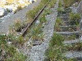 Detail of the track with the parallel stairs
 -
 Renara valley from above and quarrymen's shelter
 -
 Machinery of the quarrymen near a shelter on the line


.jpg)
See also
- Carrara marble
- Marmifera di Carrara railway
References
- ^ a b c (in Italian) Article on alpiapuane.com
- ^ (in Italian) Vie di Lizza on the Apuan Alps Archived 2014-02-21 at the Wayback Machine
- ^ (in Italian) Article about the Lizzatura (La Nazione)
- ^ a b (in Italian) List of possible heritage sites in the Apuan Alps National Park (see page 5)
- ^ a b (in Italian) Article on paesiapuani.it
- ^ (in Italian) Article on "profili apuani" website
External links
![]() Media related to Lizza di Piastreta at Wikimedia Commons
Media related to Lizza di Piastreta at Wikimedia Commons