
Llanquihue Lake
This article needs additional citations for verification. (April 2008) |
| Llanquihue Lake | |
|---|---|
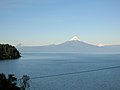
 The lake as seen from Osorno volcano with Calbuco visible on the left | |
 Llanquihue Lake | |
| Coordinates | 41°08′S 72°47′W / 41.133°S 72.783°W |
| Primary outflows | Maullín River |
| Catchment area | 1,435 km2 (554 sq mi) |
| Basin countries | Chile |
| Surface area | 860 km2 (330 sq mi) |
| Average depth | 183.7 m (603 ft) |
| Max. depth | 317 m (1,040 ft) |
| Water volume | 158 km3 (38 cu mi) |
| Shore length1 | 197 km (122 mi) |
| Surface elevation | 70 m (230 ft) |
| Frozen | never |
| Settlements | Puerto Varas, Llanquihue, Frutillar, Puerto Octay, Las Cascadas |
| 1 Shore length is not a well-defined measure. | |
Llanquihue Lakelast glacial period is called Llanquihue glaciation in Chile after the terminal moraine systems around the lake.[2]
Some historians consider Llanquihue Lake to have been within the range of ancient Chono nomadism.[3]
Llanquihue Lake is located in southern Chile a territory of northern Patagonia in the Los Lagos Region. The lake's views of
Volcán Osorno make the surrounding cities such as Puerto Varas
tourism hotspots.
Gallery
-
 A view of the Osorno volcano from across the lake

References
- ^ "Llanquihue Lake". chile.travel. Ministry of Economy, Development, and Tourism. Archived from the original on May 19, 2023. Retrieved May 18, 2023.
- ISBN 978-956-310-774-6 [page needed]
- .
External links
 Media related to Llanquihue Lake at Wikimedia Commons
 Geographic data related to Llanquihue Lake at OpenStreetMap
This article related to a lake in Chile is a stub. You can help Wikipedia by expanding it. |