
Calbuco (volcano)
| Calbuco | |
|---|---|
Ultra | |
| Coordinates | 41°19′48″S 72°37′06″W / 41.33000°S 72.61833°W[1] |
| Geography | |
 Calbuco Chile | |
| Location | South Volcanic Zone |
| Last eruption | April 2015 |
Calbuco (/kɑːlˈbuːkoʊ/ kahl-BOO-koh; Spanish: Volcán Calbuco, pronounced [bolˈkaŋ kalˈβuko]) is a stratovolcano in southern Chile, located southeast of Llanquihue Lake and northwest of Chapo Lake, in the Los Lagos Region, and close to the cities of Puerto Varas and Puerto Montt. With an elevation of 2,015 meters above sea level, the volcano and the surrounding area are protected within the Llanquihue National Reserve.
The most recent eruption, a major VEI 4 event,[2] happened with little warning on April 22–23, 2015, followed by a smaller eruption on April 30. This was Calbuco's first activity since 1972.[3][4][5]
Name and location
Calbuco is located partly in Puerto Varas Commune and partly in Puerto Montt Commune. It lies 49 km from the city of Puerto Varas and 69 km from Puerto Montt. Its name is thought to come from the Mapuche words "kallfü" (blue) and "ko" (water), meaning "blue water".[6] It shares the name with Calbuco Island in nearby Reloncaví Sound as well as the city and commune of Calbuco, although it is not located there.
Geology
Calbuco is a very explosive
Volcanic activity

Calbuco has had 36 confirmed eruptions during the Holocene, 13 of which have been recorded in historical times. 20th century eruptions took place in 1906, 1907, 1909, 1911, 1917, 1929, 1932, 1945, 1961, and 1972. A series of three eruptions occurred from April 22–30, 2015.[9]
The 1893–95 Calbuco eruption was one of the largest ever to take place in southern
In the strong explosions of April 1917, a lava dome formed in the crater accompanied by hot lahars. Another short explosive eruption in January 1929 also included an apparent pyroclastic flow and a lava flow.[citation needed]
The major eruption of 1961 sent ash columns 12–15 km high, produced plumes that dispersed mainly to the south east and emitted two lava flows. There was a minor, four-hour eruption on August 26, 1972. Strong fumarolic emission from the main crater was observed on August 12, 1996.[8]
The most recent eruption happened in April 2015, when on April 22, the volcano suddenly erupted with little warning, sending a large ash column into the atmosphere; another eruption occurred in the early hours of April 23. A smaller eruption occurred on April 30. The eruptions ranked as a 4 on the
See also
- List of volcanoes in Chile
- List of Ultras of South America
Gallery
-
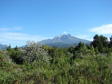 Calbuco viewed from the north alongside Road 225 on the shores of Llanquihue Lake (February 11, 2010).
 -
 From Osorno volcano (July 28, 2006).
 -
 View of the eruption column of Calbuco Volcano from Puerto Varas, Chile, on April 22, 2015.
 -
 Picture taken with VIIRS, infrared, April 23, 2015.
 -
TheSO2from the eruption.


References
- ^ a b c "Argentina and Chile: Central Ultra-Prominences". Peaklist.org. Retrieved July 7, 2013.
- ^ "Calbuco: Eruptive History". Global Volcanism Program. Smithsonian Institution. Retrieved June 29, 2021.
- ^ a b "Chile's Calbuco volcano erupts". The Guardian. April 22, 2015. Retrieved April 23, 2015.
- ^ a b "Calbuco Volcano: second eruption leaves towns and villages covered in thick blankets of dust". The Daily Mirror. April 24, 2015. Retrieved May 6, 2015.
- ^ a b "Chile's Calbuco volcano erupts again". The Guardian. April 30, 2015. Retrieved May 6, 2015.
- ^ Calbuco: Aguas Azules Ellanquihue.cl, retrieved May 6, 2015
- ^ "Calbuco: Latest Activity Reports". Global Volcanism Program. Smithsonian Institution. Retrieved June 29, 2021.
- ^ a b "Calbuco: General Information". Global Volcanism Program. Smithsonian Institution. Retrieved June 29, 2021.
- ^ "Eruptive History of Calbuco". Smithsonian Institution. Retrieved January 4, 2016.
- ISBN 84-95938-32-4.
- ^ "Global Volcanism Program - Report on Calbuco (Chile) — 19 August-25 August 2015". volcano.si.edu.
- ^ "Inédita investigación reveló efectos del volcán Calbuco sobre los mares de la Patagonia". Qué Pasa (in Spanish). La Tercera. June 24, 2021. Retrieved June 24, 2021.
Sources
- González-Ferrán, Oscar (1995). Volcanes de Chile (in Spanish). Santiago, Chile: Instituto Geográfico Militar. p. 640 pp. ISBN 956-202-054-1.
- Biggar, John (2005). The Andes: A Guide for Climbers (3rd ed.). Andes Publishing (Scotland). p. 304 pp. ISBN 0-9536087-2-7.
External links
- "Volcán Calbuco, Chile" on Peakbagger
- Se mantiene monitoreo permanente al volcán Calbuco on Onemi (in Spanish)
- Calbuco volcano description with photo gallery of its historical eruptions (in Spanish)
- Analysis of precursory activity of the 2015 eruption (in Spanish)
- First studies with results of the 2015 eruption (in Spanish)
- Videos 2015 Eruption
- Video Calbuco Volcano Erupts by National Geographic2015-04-23
- Video Timelapse Calbuco Chile 2015-04-22 on YouTube