
Llyn Crafnant
| Llyn Crafnant | |
|---|---|
 View from the summit of Crimpiau | |
 Llyn Crafnant | |
| Location | North Wales |
| Coordinates | 53°7′57″N 3°52′12″W / 53.13250°N 3.87000°W |
| Type | natural lake |
| Basin countries | United Kingdom |
| Surface area | 63 acres (25 ha) |
| Max. depth | 71 ft (22 m) |
Llyn Crafnant is a lake that lies in a valley in
Crafnant takes its name from “craf”, an old Welsh word for garlic, and “nant”, a stream or valley.
The lake can be reached by car only from
There is a Natural Resources Wales car park with toilets, which is reached just before the lake itself, and the lakeside cafe (open from Easter until late summer) offers car parking for patrons. The lake is a popular fishing spot, and is kept stocked with brown trout and rainbow trout. From the cafe, it is possible to hire boats for fishing or for pleasure. Private boating and swimming are not permitted.
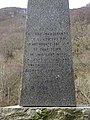
The lake is a reservoir and was dammed at its northern end in 1874, but the dam itself is barely visible as the outflow plunges down steeply from it. By the outflow is an obelisk, erected in 1896 by the inhabitants of Llanrwst which commemorates "the gift to that town of this lake with 19 acres (77,000 m2) of land" by Richard James. The lake is leased to the owners of what is now the cafe.
In the upper part of the valley there is no mains water connection and during the particularly dry summer of 2006 many properties were without water.
The
Cornel, a large property in 25 acres (10 ha) on the southern banks of the lake, is owned and operated by the Welsh
Areas around the lake have been used for location shots in
Gallery
-
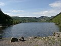 A view of Llyn Crafnant
 -
 View of Llyn Crafnant
 -
 The monument, commemorating the gift of free water to Llanrwst
 -
-


References
Further reading
- The Lakes of North Wales by Jonah Jones, Whittet Books Ltd, 1987
- The Lakes of Eryri by Geraint Roberts, Gwasg Carreg Gwalch, 1985
- Bathymetrical Survey of the Lakes of Snowdonia, by T.J. Jehu, The Royal Society of Edinburgh, 1902
| Towns | |
|---|---|
| Other settlements | |
| Rivers & streams |
|
| Lakes | |
| Waterfalls | |
| Hills & mountains |
|
| Castles & forts | |
| Bridges | |
| Other features |
|
| Transport | |
| Railway stations | |
| Authority control databases: National |
|---|