
Lokeren
This article needs additional citations for verification. (February 2015) |
Lokeren | ||
|---|---|---|
City and municipality | ||
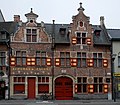
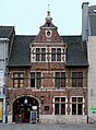
 The Old Postoffice of Lokeren | ||
 Flag  Coat of arms | ||
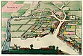
Location of Lokeren  | ||
 Lokeren Location in Belgium
Location of Lokeren in East Flanders Region Flemish Region | | |
| Province | East Flanders | |
| Arrondissement | Sint-Niklaas | |
| Government | ||
| • Mayor | Filip Anthuenis ( Open VLD) | |
| • Governing party/ies | Open VLD, CD&V | |
| Area | ||
| • Total | 68.24 km2 (26.35 sq mi) | |
| Population (2022-01-01)[1] | ||
| • Total | 42,703 | |
| • Density | 630/km2 (1,600/sq mi) | |
| Postal codes | 9160 | |
| NIS code | 46014 | |
| Area codes | 09 | |
| Website | www.lokeren.be | |
Lokeren (Dutch pronunciation:
Toponym
A group of authors see the element luken in the place name, which means (en)close or to close, to shut. Lokeren would refer to an enclosed place between the Durme and a forest area with wild animals.
According to another theory, the name Lokeren would derive from, on the one hand, the Indo-European root word leuk, which means clear or shiny, and on the other hand, the prehistoric
History
Origins
.jpg)

Archaeological finds on the Lokeren territory prove that this area was populated in Neolithic times. A Roman road ran along the Durme river. The name Waas was given to this area by the Romans from the Germanic root Wasu meaning "marshy land". The first mention of the name Lokeren, however, dates from 1114.[4] Unlike the older settlements, the new village came to be built on the right bank of the Durme. By the middle of the 12th century, it had become an independent parish, with agriculture and flax as the two main drivers of the economy. The textile industry would remain important until well into the 20th century.
14th century to 16th century
Since its inception, Lokeren has been extensively connected with other settlements and places. The city center itself is in fact a major junction of regional roads connecting Lokeren with other important places. From those important roads came branches that today form the basis of the city center.
From the Middle Ages to the end of the 18th century, the territory of Lokeren fully belonged to the
16th century to 17th century

In 1555,
18th century to 19th century

After the
In the 18th century, Lokeren, except for Ghent, had the most inhabitants of East Flanders, the then Département de l'Escaut. This demographic expansion was the result of the favorable economic climate. However, the population density was lower than in Sint-Niklaas, for example.
In the course of the 18th century, trade over water in Lokeren increased. As a result of this increasing practice, a meander of the Durme was cut off near the Buylaers. The muted meander is visible on the Ferraris map. In 1725 the Church of Saint Laurence was built on the Markt.


In December 1845, the college of aldermen asked the governor whether the city could build a station and a railway bridge over the Durme. This was necessary to create employment after the failed harvest so that the affected families could provide for themselves. The urban image of Lokeren was radically changed by the construction of a station along the Ghent-Antwerp railway. The station opened on 7 August 1847 and was located north of the Durme, in the lake area, just under 400 meters from the Markt. This station was equipped for both goods and passengers. Not much time later, the station was divided into two stations, Lokeren station and Dender & Waas station. The station building itself survived until it was destroyed during World War II.
With the opening of this station and the construction of Stationsstraat, new neighborhoods were constructed on the left bank of the Durme. In the 19th century, the hamlet of Heirburg was completely connected to the center.
In the 19th century, Lokeren was booming industrially. The industrial buildings in Lokeren were rarely larger than 4 ares. In Lokeren people did not feel compelled to build factories because the cottage industry was still sufficiently profitable. Lokeren mainly focused on conservative craft sectors: the millinery and linen bleaching. This kept the city up until the early 20th century. Larger factories were later constructed.
At the end of the 19th century, this favorable course came to an end for Lokeren. Other East Flemish cities such as Aalst and Sint-Niklaas took the lead.
20th century
The First World War slowed the city's growth, although the city came out virtually unscathed. During the German occupation during the Second World War, a Durchgangslager (transit camp) was set up between Bleekmeerstraat and Oude Bruglaan with the main purpose of bringing English prisoners of war together awaiting their deportation. After the liberation (during the repression) this camp was set up as an internment center for collaborators. The Lokeren Internment Center (Hechteniskamp Lokeren) was one of the largest of its kind and held between 15,000 and 22,000 detainees from September 1944 to November 1947.
Lokeren experienced a rapid and stable reconstruction of the city in the post-war period. Bombed-out houses were renovated or rebuilt, and the badly damaged station was demolished and replaced by a more modern one. Many bridges over the Durme and Lede were also rebuilt. This was followed by a major expansion of the Lokeren city center, both on a residential and industrial level.
Industry

Factories in the center continued to operate until the 1980s, when it was decided that all industrial activities should be better located outside the city core. With the decline of the secondary sector from the 1950s onward, large factories in the city center such as Nijverheidstraat, Oude Durme, Hoedhaar, etc. were closed one by one.
New industrial areas were planned outside the city center at Den Oever, Rozen and Everslaar. The Lokeren-Oost freight station was also constructed and would replace the old Dender & Waas freight station. In 2018 it was announced that the Everslaer industrial park was going to be expanded. The chocolatier Callebaut bought a large piece of land where the largest chocolate warehouse in Europe would later be built. In the 1970s, the railway lines 59 and 57, which run right through the center, were laid on a viaduct. As a result, the center was divided into three parts.
Expansion of the city center
Between 1960 and 1980, Lokeren expanded its residential area further north of the center. Neighborhoods were constructed between railway lines 59 & 77A and the N70. Later, further expansion was carried out on and around the N70 and the Oude Heerweg. After the ring or N47 was built around Lokeren, the southern part of the center was further expanded. The hamlets of Spoele and Bokslaar became neighborhoods as a result. Today, these districts extend all the way to the E17, between the N47, railway line 57 and the Everslaer industrial estate. The western part of the center was also expanded, but to a lesser extent. Because of this growth, Baudouin of Belgium paid a visit to Lokeren on 10 June 1956.
Since the merger of 1 January 1977, the sub-municipalities of Eksaarde and Daknam have been part of Lokeren. Daknam and Lokeren, however, have been one administrative unit since 1794.
Sights
- Lokeren counts a number of art galleries and a museum, which covers local history from prehistoric archaeology to the mid-20th century.
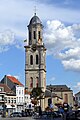
- Sint-Laurentius Church, built in 1725.
- Since 10 June 1956, the city has been endowed with a 49-bell carillon.
- The Molsbroek nature preservation area is on Lokeren's territory.
- The façade of the Sint-Lodewijks college, High-School.
-
 Sketch of the former Sterrebeek Castle
 -
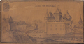
 Lokeren in Flandria Illustrata (1641)
 -
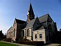
 Church of Our Lady, built before 1156, with southern part added in the 15th century
 -
 Church of the Ascension, built in 1230 and thoroughly restored in the 17th century after being badly damaged in the 1570s
 -
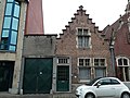
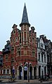
 Hooghuys, built in 1568
 -
 Former tavern built in 1621 on Kerkstraat
 -
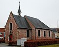
 Kruiskapel, built in 1626
 -
 1633 chapel on Luikstraat
 -
 17th-century houses
 -
 Sint-Annakapel, destroyed in 1568 and rebuilt in 1644
 -
 House built in 1663
 -
 17th-century house on Vrijheidsplein
 -
 Huis Groene Poort, 17th century
 -
 Church of Saint Laurence
 -
 Detail of pulpit, Church of Saint Laurence
 -
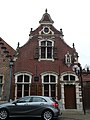
 The Old Post Office
 -
 The Durme river
 -
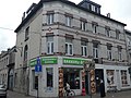
 The Brughuis on Stationstraat


_01.jpg)


Notable inhabitants
- fl.1375–1381)
- Hendrick de Somer, painter (1602–1656)
- Pieter Legouch, painter (?–1664)
- Abraham Smit, painter (c. 1621–1672)
- Ghent(1674–1741)
- Joséphine Nyssens Keelhoff, activist, social reformer, editor (1833-1917)
- Frans Rens, writer (1805–1874)
- August De Wilde, painter (1819–1886)
- Miet Smet, politician (b. 1943)
- Aimé Anthuenis, former football player and coach (b. 1943)
- Eastern Orthodox church(b. 1946)
- gynaecologist(b. 1953)
- Willy Linthout, comics author (b. 1953)
- François Van Der Elst, former international football player (b. 1954)
- Chris Van den Durpel, actor and imitator (b. 1960)
- Paul Verhaeghen, novelist (b. 1965)
- Femke Maes, former international football player (b. 1980)
- Jelle Van Damme, former international football player (b. 1983)
- Linde Merckpoel, radio presenter (b. 1984)
- Greg Van Avermaet, professional cyclist (b. 1985)
- Killian Overmeire, former international football player (b. 1985)
- Lorca Van De Putte, football player (b. 1988)
- Manuel Benson, football player (b. 1997)
- Luka van den Keybus, gymnast (b. 1997)
- Tim Coppens, fashion designer
Sports and events

- The best football club of the city is K.S.C. Lokeren Oost-Vlaanderen.
- Lokeren is well known within Flanders for an annual ten-day music fest and fair (the Lokerse Feesten), which takes place during the first week of August.
On 14 July 1970, Lokeren was the scene of a sporting disaster, when a minibus carrying a team of speedway riders from West Ham, London, was involved in a collision with a petrol tanker. 4 riders were killed, two seriously injured and Phil Bishop a famous speedway ace from the 1930s, who was managing the team was also killed.[6]
References
- ^ "Bevolking per gemeente op 1 januari 2022". Statbel.
- University of Gent, 2007-2008.
- ^ "Kroniek van Lokeren". lib.ugent.be. Retrieved 27 August 2020.
- ISBN 9789081364638.
- ^ Paul Lindemans. Geschiedenis van de landbouw in België (in Dutch).
- ^ "Tragic West Ham speedway crash remembered on 46th anniversary".
External links
![]() Media related to Lokeren at Wikimedia Commons
Media related to Lokeren at Wikimedia Commons
- Official website (in Dutch)
- Sporting Lokeren – Information about K.S.C Lokeren Oost-Vlaanderen
- Lokerse Feesten – Information about the annual Lokeren music festival "Lokerse Feesten"
- Lokeren in beeld – Views of Lokeren
- . Encyclopædia Britannica (11th ed.). 1911.
Places adjacent to Lokeren | |
|---|---|
| Aalst |  | |
|---|---|---|
| Dendermonde | ||
| Eeklo | ||
| Ghent | ||
| Oudenaarde | ||
| Sint-Niklaas | ||
| ||
| International | |
|---|---|
| National | |
| Geographic | |
| Other | |