
Longdendale
| Longdendale | ||
|---|---|---|
Metropolitan county | ||
| Region | ||
| Country | England | |
| Sovereign state | United Kingdom | |
| Police | Greater Manchester | |
| Fire | Greater Manchester | |
| Ambulance | North West | |
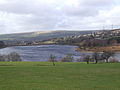
Longdendale is a valley in the Peak District of England, north of Glossop and southwest of Holmfirth. The name means "long wooded valley" and the valley is mostly in the counties of Derbyshire and Greater Manchester.

Geography
The eastern part of the valley is in the non-metropolitan county of Derbyshire and includes the village of Tintwistle and, further east, part of the Peak District National Park, with the last half-mile or so falling into the Metropolitan Borough of Barnsley in South Yorkshire. The western part of the valley, including the villages of Broadbottom, Mottram in Longdendale and Hollingworth is part of Tameside in the metropolitan county of Greater Manchester. The whole of Longdendale forms the easternmost extension of the lands within the historic boundaries of Cheshire.
The
-
 Bottoms
 -
 Valehouse
 -
 Rhodeswood
 -
 Woodhead


History
The Romans
There is a Roman fortlet at Highstones on the south-facing slope overlooking Torside Reservoir. It is an oval-shaped area, with an obvious ditch, and about 82 yards (75 m) across. A footpath runs immediately to the north of it, and to the west is Highstones Farm. A Roman road may have run along the valley connecting it with
Feudal estates
The lordship of Longdendale was an ancient feudal estate encompassing the medieval
Salt trade

A
Turnpike road
The turnpike road from Manchester to Saltersbrook connected to further turnpikes for Yorkshire destinations and was built in the mid-18th century, based on the older saltway route.
The reservoirs
The Longdendale catchment exceeds 30 square miles (78 km2) and has an annual rainfall of 1,330 millimetres (52.5 in). The civil engineer
The railway
The first railway line between
Recreation
Cycling and walking

After the rail line was closed, the trackbed was taken up and the
The Pennine Way crosses Longdendale, descending from Bleaklow to the south and ascending Black Hill to the north. The youth hostel at Crowden is a traditional stop after the first day's walk from Edale. The circular walk known as 'The Longdendale Edges' takes in the high ground (at about the 1,000–1,500-foot (300–460 m) level) on both sides of the valley. It is about 17 miles (27 km) long and is 'not recommended in doubtful weather'. The detailed route, clockwise from Crowden Youth Hostel, is given in Peak District Walking Guide No.2, published by the Peak Park Planning Board.
Sailing
Torside Reservoir is home to Glossop Sailing Club.[13]
Transport
Woodhead pass road
The
As of January 2008 there are advanced plans to improve the A628 route by bypassing Mottram and Tintwistle to the north with a spur to the A57 road. Known as the 'A57/A628 Mottram-in-Longdendale, Hollingworth & Tintwistle Bypass' or Longdendale Bypass, the public inquiry has been adjourned four times and is currently adjourned 'indefinitely'.[14]
Governance
The valley gave its name to the Longdendale Urban District, which covered the western part of the valley around Mottram and Hollingworth. That district was created in 1936 as one of the districts of Cheshire, and was abolished in 1974 when its area became part of the metropolitan borough of Tameside in Greater Manchester.[15][16]
Traditionally, Longdendale was in the County palatine of Chester. Up until local government reforms in 1974, Longdendale Urban District, along with Tintwistle Rural District, formed part of the administrative county of Cheshire; the Municipal Borough of Glossop was in Derbyshire; and Penistone Rural District was in the West Riding of Yorkshire. Today, the valley is split between the Metropolitan Borough of Barnsley in South Yorkshire, the Borough of High Peak in Derbyshire, and the Metropolitan Borough of Tameside in Greater Manchester.
Longdendale lights
The valley and the surrounding area has a reputation for strange phenomena, including unexplained lights
See also
References
- ^ "Longdendale". cheshirenow.co.uk. Retrieved 8 April 2015.
- ^ Lee, Gordon. "Castleshaw Roman Forts". www.oldham.gov.uk. Retrieved 11 February 2022.
- ISBN 1-871324-12-2.
- ISBN 1-871324-18-1.
- ISBN 1-871324-24-6.
- ISBN 1-871324-02-5.
- ISBN 1-871324-08-4.
- ^ On-site information board.
- ^ Durant, M. J.; Counsell, C. J. (2018). "Inventory of reservoirs amounting to 90% of total UK storage". NERC Environmental Information Data Centre. Retrieved 20 March 2025.
- ISBN 0-7524-3198-6.
- ^ "Signed Cycle Routes in Manchester". Manchester City Council. Archived from the original on 11 January 2008. Retrieved 25 January 2008.
- ^ Fortheringham, William (17 January 2013). "Tour de France 2014: Leeds chosen for start as English route is unveiled". The Guardian. Retrieved 18 January 2013.
- ^ "Directions". Glossop Sailing Club. Retrieved 1 August 2017.
- ^ "The Mottram/Tintwistle Bypass and Glossop Spur Public Inquiry – News". Persona. Archived from the original on 22 June 2007. Retrieved 21 January 2008.
- ^ "Longendale [sic] Urban District". A Vision of Britain through Time. GB Historical GIS / University of Portsmouth. Retrieved 18 February 2025.
- ^ "Local Government Act 1972: Schedule 1". legislation.gov.uk. The National Archives. 1972 c. 70 (sch. 1). Retrieved 15 January 2025.
- ^ a b "Peak viewing for ghouls". BBC News. 21 April 1999. Retrieved 8 April 2015.
- ^ Clarke, David. "The Longdendale Lights". Dr. David Clarke. Retrieved 23 January 2009.
- ^ "Legends of Longdendale". Longdendale Online. Archived from the original on 14 May 2008. Retrieved 8 April 2015.
Further reading
- Middleton, Thomas (1906). Legends of Longdendale. Clarendon Press.
External links
53°29′44″N 1°47′42″W / 53.49563°N 1.79496°W
| International | |
|---|---|
| National | |