A57 road

Route map:
Source: Wikipedia, the free encyclopedia.

A57 shield
A57
M60 Junction 11)
Major junctions
West endLiverpool James Street railway station
Major intersections
  • M57
  • M62
  • M6
  • M60
  • M602
  • M67
East end
Lincoln
Location
Country
Primary
destinations
Road network
A58

The A57 is a major road in

Salford and Manchester, and then through the Pennines over the Snake Pass (between the high moorlands of Bleaklow and Kinder Scout), around the Ladybower Reservoir, through Sheffield and past Worksop. Between Liverpool and Glossop, the road has largely been superseded by the M62, M602 and M67 motorways. Within Manchester a short stretch becomes the Mancunian Way
, designated A57(M).

Route

Liverpool–Warrington

The A57 begins at The Strand (A5036) near the

, it becomes a dual-carriageway and meets the A562 at a roundabout.

Warrington–Manchester

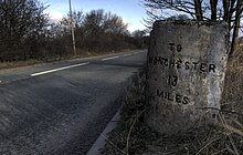
A milestone along the A57, indicating the Warrington and Lower Irlam Turnpike Trust road, near Rixton. The opposite side gives the distance to Warrington.

The original route through Warrington town centre included the narrow Sankey Street, which required special narrow buses to be operated. The road now bypasses Warrington town centre via a new elevated road, Midland Way, before emerging at a roundabout junction with the

Glazebrook and its railway station, and then it crosses Glaze Brook as Liverpool Road, entering the metropolitan district of Salford
.

Irlam bypass being built in September 2005

There is a new roundabout with the former road through

Barton-upon-Irwell
close by to the south.

Patricroft Bridge over the Bridgewater Canal

Soon after this junction the road enters

A576 (for Trafford Park. It leaves the A576 near junction 2 of the M602, heading east as the single-carriageway Eccles New Road. It passes the Ladywell tram stop on the right and meets the A5185 to the left. The Metrolink follows the road on the right hand side. There is the B5228 to the left near the Weaste station. In Weaste, there is the Langworthy tram stop
near the A5186 left turn where the Metrolink leaves the road to the south. The road runs parallel to the M602 100m to the north.

Regent Road entering from Salford

The road becomes the trunk road dual carriageway Regent Road at the junction with the terminus of the M602 and the A5063 (Albion Way north for the

A57(M) – the Mancunian Way at the GSJ with the A56 Bridgewater Way. The Beetham Tower Manchester
is seen nearby to the left.

Manchester–Sheffield

Mancunian Way

It leaves the A57(M) at the

A6010 at crossroads. It passes through Belle Vue, meets the B6178 (for Levenshulme), crosses a railway near the Belle Vue railway station, entering Gorton. It meets the B6167 (for North Reddish). It enters the borough of Tameside
, becoming the dual-carriageway Manchester Road.

It meets the

Glossop Line near Godley railway station and Godley Reservoir. It passes through Hattersley, and mets the final junction of the M67 – junction 4 – at a roundabout with the dual-carriageway A560 (for Stockport
).

Passing through Glossop

It resumes its trunk road status as Hyde Road, passing through

Dinting viaduct, again near Dinting railway station as it passes through Dinting and the primary school. The A6016 leaves to the right and the road enters Glossop as High Street West passing a Tesco on the left. It meets the A624 (for Hayfield) and the B6105 at crossroads in the middle of the town, near Norfolk Square and the railway station. It becomes High Street East, passing Glossop Leisure Centre on the right. There is a roundabout and it becomes Sheffield Road, then Woodcock Road as it leaves Glossop and enters the Peak District National Park (Dark Peak). There is a sharp bend to the right and it becomes Snake Pass
.

It climbs up Holden Clough and at Featherbed Moss, it is crossed by the

A6013 (for Bamford) and passes the Ladybower Inn. It climbs the valley and passes over Cutthroat Bridge. It is at about 1200 ft as it enters South Yorkshire and the city of Sheffield. It follows down the hill as Manchester Road past Hollow Meadows
.

The Rivelin valley

Following the hill down into Sheffield, it passes the New Norfolk Arms on the left, with the

Broomhill
. The B6069 leaves to the right, and it becomes Whitham Road.

It passes

River Don on Castlegate, becoming Exchange Place. It becomes the Sheffield Parkway (built in 1974), Sheffield's main route to the M1
, meeting a roundabout.

Sheffield–Worksop

View towards Mosborough

It meets the

Beighton. It crosses the River Rother, entering the borough of Rotherham
, and meets a roundabout.

View towards Aston

It crosses the

Shell Worksop Road station. It crosses a railway and Lindrick Common near Woodsetts
.

Worksop–Lincoln

Worksop bypass

The 5-mile (8 km) £11.3 million

A60 (for Worksop) at the Rhodesia Roundabout, near Rhodesia, a Sainsbury's and a McDonald's. The next short section, overlapping with the A60 and crossing the River Ryton, is dual-carriageway to the roundabout with the A60 (for Mansfield) and B6024, near the Shell Dukeries Garage and the Worksop Little Chef. From here, it is single carriageway (excluding the A1 section). There is a roundabout with the B6034 (for Ollerton) near Worksop College
and Portland School.

Little Chef (now closed) at Markham Moor, a former petrol station designed by Sam Scorer

It passes the former site of

Cottam
and (former) High Marnham are to the north and south, with many lines of pylons following the Trent.

Dunham bridges over the Trent

It goes through

Sheffield to Lincoln Line and Fossdyke, meeting the B1241, for Sturton by Stow
.

Crossing the River Till

It crosses the

Siemens
engineering company.

Although the terminus of the road is in Lincoln, most of the A57 follows the former Liverpool-Skegness trunk road, created by the 1946 Trunk Roads Act. The road from Lincoln to Skegness was formerly also known as the A158.

History

1979 - Snake Pass potential closure

In 1979, the Department for Transport considered closing the Snake Pass section with traffic to be diverted to use the A628.

1985 - Opening of Aston relief road

The 3-mile (4.8 km) £4 million Aston relief road in Sheffield opened in mid-1985, with the old route now designated as the B6200.

2017 - Transpennine road upgrade

In 2017,

Highways England
announced a consultation for upgrades to road in the Transpennines. This includes:

  • Upgrades to the Westwood roundabout near Sheffield; packaged with technology improvements along the A628, A616 and A61, including electronic signs and improved closure gates
  • Creation of two new link roads at the western end of the A57/A628 route, to provide a dual carriageway bypass around Mottram in Longdendale[3] 

References

  1. ^ West Drayton diversion
  2. ^ Historic England. "Canopy to former petrol station, Markham Moor (1402678)". National Heritage List for England. Retrieved 15 August 2012.
  3. ^ National Highways (26 May 2020). "A57 Link Roads". National Highways. Retrieved 6 July 2022. Text was copied from this source, which is available under an Open Government Licence v3.0. © Crown copyright.

External links

KML is from Wikidata