
Lubec, Maine
Lubec, Maine | ||
|---|---|---|
West Quoddy Head Lighthouse and Quoddy Narrows, with Grand Manan Island , Canada, in background | ||
|
FIPS code 23-41610 | | |
| GNIS feature ID | 0582570 | |
| Website | townoflubec | |
Lubec (/luːˈbɛk/ loo-BEK) is a town in Washington County, Maine, United States. It is the easternmost municipality in the contiguous U.S. (see extreme points of the United States) and is the country's closest continental location to Africa.[2]
The town, with a population of 1,237 at the
History
Located on a
From 1897 to 1898, the town was the site of a swindle in the sale of stock in the Electrolytic Marine Salts Company, the brainchild of Reverend Prescott Jernegan and Charles Fisher of Martha's Vineyard.[6] Jernegan claimed to have developed a method of using "accumulators" to get gold from sea water, and bought an old grist mill to turn it into a factory. The scheme attracted an abundance of investors, who were all too eager to funnel money into the company after being promised astronomical returns. In the summer of 1898, work was suspended without explanation. Jernegan and Smith vanished, and the fraud was gleefully exposed by newspapers across New England.[6]
Lubec reached its population peak in the 1910s and 1920s, hovering a little above 3,300. Since then, the population has generally been in a gradual but steady decline. As of 2020, its population had fallen to 1,237.
-
 General view c. 1910
 -
 War monument in 1908
 -
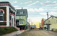 Bank Square c. 1908
 -
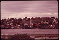 Lubec in 1973


Geography
Lubec is located in northeastern Maine, at 44°51′38″N 66°59′5″W / 44.86056°N 66.98472°W.[7]
According to the
Lubec is the
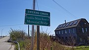
Lubec is crossed by Maine State Route 189. The Franklin Delano Roosevelt Bridge connects the town to Campobello Island, New Brunswick, Canada.
Sites of interest
-
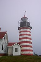 West Quoddy Head Lighthouse
 -
 Center of Lubec as seen from Campobello Island


Bay of Fundy International Marathon
The Bay of Fundy International Marathon is a marathon between Lubec and Campobello Island, New Brunswick, Canada. A 10K is also organized alongside the marathon. The 10K takes place entirely within Lubec.[10]
The race begins at
The first marathon was run in 2013. It included over 500 registered runners and was held in June. The race provided significant economic benefits to the area. The 2014 edition featured fewer runners (286 total). The organizers attributed the decrease to the "Boston effect", whereby marathon runners chose other marathons to run in order to qualify for the 2014 Boston Marathon.[10]
Climate
Lubec has a
| Climate data for Lubec, Maine | |||||||||||||
|---|---|---|---|---|---|---|---|---|---|---|---|---|---|
| Month | Jan | Feb | Mar | Apr | May | Jun | Jul | Aug | Sep | Oct | Nov | Dec | Year |
| Record high °F (°C) | 61 (16) |
65 (18) |
79 (26) |
84 (29) |
93 (34) |
96 (36) |
98 (37) |
95 (35) |
94 (34) |
84 (29) |
71 (22) |
60 (16) |
98 (37) |
| Mean daily maximum °F (°C) | 30 (−1) |
32 (0) |
39 (4) |
50 (10) |
60 (16) |
69 (21) |
74 (23) |
74 (23) |
67 (19) |
56 (13) |
46 (8) |
36 (2) |
53 (12) |
| Daily mean °F (°C) | 22 (−6) |
25 (−4) |
32 (0) |
42 (6) |
51 (11) |
59 (15) |
64 (18) |
64 (18) |
58 (14) |
48 (9) |
40 (4) |
29 (−2) |
45 (7) |
| Mean daily minimum °F (°C) | 14 (−10) |
17 (−8) |
24 (−4) |
34 (1) |
41 (5) |
48 (9) |
54 (12) |
54 (12) |
49 (9) |
40 (4) |
33 (1) |
21 (−6) |
36 (2) |
| Record low °F (°C) | −27 (−33) |
−23 (−31) |
−13 (−25) |
1 (−17) |
24 (−4) |
31 (−1) |
36 (2) |
33 (1) |
23 (−5) |
15 (−9) |
3 (−16) |
−23 (−31) |
−27 (−33) |
| Average precipitation inches (mm) | 3.83 (97) |
3.24 (82) |
4.07 (103) |
3.67 (93) |
3.77 (96) |
3.66 (93) |
2.98 (76) |
3.10 (79) |
4.11 (104) |
4.37 (111) |
4.87 (124) |
4.27 (108) |
45.94 (1,167) |
| Source: The Weather Channel[11] | |||||||||||||
Demographics
| Census | Pop. | Note | %± |
|---|---|---|---|
| 1820 | 1,430 | — | |
| 1830 | 1,535 | 7.3% | |
| 1840 | 2,307 | 50.3% | |
| 1850 | 2,814 | 22.0% | |
| 1860 | 2,555 | −9.2% | |
| 1870 | 2,136 | −16.4% | |
| 1880 | 2,109 | −1.3% | |
| 1890 | 2,769 | 31.3% | |
| 1900 | 3,005 | 8.5% | |
| 1910 | 3,363 | 11.9% | |
| 1920 | 3,371 | 0.2% | |
| 1930 | 2,994 | −11.2% | |
| 1940 | 3,108 | 3.8% | |
| 1950 | 2,973 | −4.3% | |
| 1960 | 2,684 | −9.7% | |
| 1970 | 1,949 | −27.4% | |
| 1980 | 2,045 | 4.9% | |
| 1990 | 1,853 | −9.4% | |
| 2000 | 1,652 | −10.8% | |
| 2010 | 1,359 | −17.7% | |
| 2020 | 1,237 | −9.0% | |
| U.S. Decennial Census[12] | |||
As of 2000 the median income for a household in the town was $20,565, and the median income for a family was $26,098. Males had a median income of $25,170 versus $19,375 for females. The
2010 census
As of the
There were 682 households, of which 16.9% had children under the age of 18 living with them, 39.4% were married couples living together, 8.7% had a female householder with no husband present, 4.1% had a male householder with no wife present, and 47.8% were non-families. Of all households 41.9% were made up of individuals, and 20.9% had someone living alone who was 65 years of age or older. The average household size was 1.94 and the average family size was 2.58.
The median age in the town was 54 years. 14.1% of residents were under the age of 18; 4.3% were between the ages of 18 and 24; 16.4% were from 25 to 44; 36.9% were from 45 to 64; and 28.3% were 65 years of age or older. The gender makeup of the town was 48.4% male and 51.6% female.
Education
Lubec Consolidated School belongs to Maine School Administrative District #19. Kenneth Johnson is the Superintendent of Schools.[14]
Notable people
- Myron Avery, lawyer, explorer
- James Henry Carleton, brevet major general in the U.S. Army[15]
- Hazel Marion Eaton, daredevil, shallow diver, long distance swimmer, hoop roller, motordome thrill racer – one of the "mile a minute girls". Close friend of Beatrice Houdini
- Albert Brewer Guptill, author and photographer[16]
- Sumner Pike, member of the US Securities and Exchange Commission, member of the Atomic Energy Commission
- Hopley Yeaton, ship captain, considered the "Father of the US Coast Guard"
Gallery
-
 West Quoddy Head Lighthouse at Sunset
 -
 Water Street, Lubec, Maine
 -
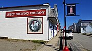 Lubec Brewing Company
 -
 US-Canada Border in Lubec, Maine
 -
 Welcome to Lubec Sign
 -
 West Quoddy Head Lighthouse
 -
 4th of July in Lubec, 2020


See also
References
- ^ "2020 U.S. Gazetteer Files". United States Census Bureau. Retrieved April 8, 2022.
- ^ "The closest point in the United States to Africa". www.acscdg.com. Archived from the original on 2015-09-18. Retrieved 2015-09-08.
- ^ "Census - Geography Profile: Lubec town, Washington County, Maine". United States Census Bureau. Retrieved January 20, 2022.
- ^ Coolidge, Austin J.; John B. Mansfield (1859). A History and Description of New England. Boston, Massachusetts: A.J. Coolidge. p. 201.
coolidge mansfield history description new england 1859.
- ^ Varney, George J. (1886). "Gazetteer of the state of Maine. Lubec". Boston: Russell.
- ^ a b Klondike: Lubec's Gold from Sea Water Hoax
- ^ "US Board on Geographic Names". United States Geological Survey. 2007-10-25. Retrieved 2008-01-31.
- ^ "US Gazetteer files 2010". United States Census Bureau. Retrieved 2012-12-16.
- ^ "Chapter 1: Eastern Maine". United Divide: A Linear Portrait of the USA/Canada Border. The Center for Land Use Interpretation. Winter 2015.
- ^ a b c Cox, Tim (June 11, 2014). "Bay of Fundy International Marathon runners to flock Down East". Bangor Daily News. Retrieved 15 June 2014.
- ^ "Climate Statistics for Lubec, Maine". Retrieved 2020-10-29.
- ^ "Census of Population and Housing". Census.gov. Retrieved June 4, 2015.
- ^ "U.S. Census website". United States Census Bureau. Retrieved 2012-12-16.
- ^ "Maine School Administrative District #19". Maine School Administrative District #19. Retrieved 2012-07-06.
- ^ "James Carleton (U.S. National Park Service)". www.nps.gov. Retrieved 12 March 2021.
- ^ "Harvard University. Class of 1878". 1908. Retrieved 12 December 2018.
Further reading
- Joshua M. Smith, Borderland Smuggling: Patriots, Loyalists and Illicit Trade in the Northeast, 1783–1820 (Gainesville, University Press of Florida, 2006)
External links
- Town of Lubec official website
- Lubec Memorial Library
- West Quoddy Head Lighthouse
- Quoddy Head State Park
- Visit Lubec Maine
- Bay of Fundy International Marathon – held in Lubec, Maine and Campobello Island, New Brunswick
Municipalities and communities of Washington County, Maine, United States | ||
|---|---|---|
| Cities |  | |
| Towns |
| |
| Plantations | ||
| Unorganized territories | ||
| CDPs | ||
| Other villages | ||
| Indian reservations | ||
| ||
| International | |
|---|---|
| National | |