
Lysander, New York
Lysander, New York | ||
|---|---|---|
Town Council Members' List | ||
| Area FIPS code | 36-44039 | |
| GNIS feature ID | 0979177 | |
| Website | www | |
Lysander is a
History


The town was part of the former
Geography
According to the United States Census Bureau, the town has a total area of 64.6 square miles (167 km2), of which 61.9 square miles (160 km2) is land and 2.7 square miles (7.0 km2) (4.18%) is water.
The northern town line is the border of Oswego County and the western town boundary is the border of Cayuga County. The southern town line is defined by the Erie Canal-Seneca River complex. Cross Lake is located on the western border of Lysander. The Oswego River marks part of the eastern town line. The Oswego, Seneca, and Oneida Rivers join at the eastern town line.
New York State Route 370, West Genesee Road, is an east-west highway in the southern part of Lysander. New York State Route 48 is a highway in the center of the town. New York State Route 31 intersects NY-370 in the southeastern part of Lysander. New York State Route 690 is a major highway leading out of the southern part of Lysander.
Demographics
| Census | Pop. | Note | %± |
|---|---|---|---|
| 1820 | 1,723 | — | |
| 1830 | 3,228 | 87.3% | |
| 1840 | 4,306 | 33.4% | |
| 1850 | 5,833 | 35.5% | |
| 1860 | 4,741 | −18.7% | |
| 1870 | 4,944 | 4.3% | |
| 1880 | 4,903 | −0.8% | |
| 1890 | 5,163 | 5.3% | |
| 1900 | 4,838 | −6.3% | |
| 1910 | 4,509 | −6.8% | |
| 1920 | 4,725 | 4.8% | |
| 1930 | 4,849 | 2.6% | |
| 1940 | 5,207 | 7.4% | |
| 1950 | 6,798 | 30.6% | |
| 1960 | 10,225 | 50.4% | |
| 1970 | 11,968 | 17.0% | |
| 1980 | 13,897 | 16.1% | |
| 1990 | 16,346 | 17.6% | |
| 2000 | 19,285 | 18.0% | |
| 2010 | 21,759 | 12.8% | |
| 2020 | 23,074 | 6.0% | |
| U.S. Decennial Census[3] | |||
As of the
There were 7,139 households, out of which 39.8% had children under the age of 18 living with them, 64.5% were married couples living together, 7.9% had a female householder with no husband present, and 24.3% were non-families. 19.9% of all households were made up of individuals, and 7.7% had someone living alone who was 65 years of age or older. The average household size was 2.70 and the average family size was 3.12.
In the town, the population was spread out, with 28.8% under the age of 18, 5.5% from 18 to 24, 30.0% from 25 to 44, 25.4% from 45 to 64, and 10.3% who were 65 years of age or older. The median age was 38 years. For every 100 females, there were 97.7 males. For every 100 females age 18 and over, there were 93.3 males.
The median income for a household in the town was $59,128, and the median income for a family was $67,539. Males had a median income of $47,057 versus $29,164 for females. The
-
 Apartments in Lysander just outside Baldwinsville
 -
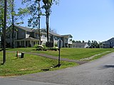
 Neighborhood in eastern Lysander
 -
 Single family homes in Lysander
 -
 Farmland in Lysander
 -
 Lysander countryside in the spring
 -
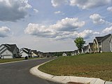
 Neighborhood in Radisson planned community
 -
 New homes just outside Baldwinsville
 -
 New home under construction in Lysander


Communities and locations in the Town of Lysander

- Baird Corners – A hamlet in the northwestern part of the town on Plainville Rd, a continuation of Oswego County Road 8
- Baldwinsville – The northern part of the Village of Baldwinsville is in the south part of the town, and is divided by the Seneca River/Erie Canal.
- Belgium – A hamlet by the eastern town line on NY-31.
- Cold Springs – A hamlet in the southeastern part of town on NY-370.
- Jacksonville – A hamlet in the northern part of the town.
- Jack's Reef – A hamlet in the southwestern section of town along the Seneca River. This hamlet is trisected with the towns of Lysander, Elbridge and Van Buren.
- Hortontown – A farm in the central part of the town.
- Lamson – A hamlet in the northern part of the town.
- Little Utica – A hamlet in the northern section of the town.
- Lysander – The hamlet of Lysander near the western town line on Plainville Rd, a continuation of Oswego County Road 8
- Beaver Lake – A lake west of Hortontown.
- Plainville – A hamlet in the southwestern part of the town on NY-370.
- Radisson – A hamlet and planned community in the eastern part of the town.
- Red Rock – A hamlet in the southeastern part of town along the Seneca River/Erie Canal.
- Seneca Estates – An upscale neighborhood of approximately 120 homes adjacent to Rt. 370 and the Seneca River, 2 miles (3.2 km) west of the Village of Baldwinsville. The only neighborhood in the town with its own private marina, boat launch, fuel station and head pump-out facility.
- West Phoenix – A hamlet in the northeastern corner of Lysander.
- Wrights Corners – A location east of Lamson, located on NY-48.
Notable people
- Esther Baker Steele (1835–1911), educator, author, traveler, philanthropist[5]
References
- ^ "2016 U.S. Gazetteer Files". United States Census Bureau. Retrieved July 5, 2017.
- ^ Gannett, Henry (1905). The Origin of Certain Place Names in the United States. U.S. Government Printing Office. p. 193.
- ^ "Census of Population and Housing". Census.gov. Retrieved June 4, 2015.
- ^ "U.S. Census website". United States Census Bureau. Retrieved January 31, 2008.
- Newspapers.com..
 This article incorporates text from this source, which is in the public domain
External links
Municipalities and communities of Onondaga County, New York, United States | ||
|---|---|---|
| City |  | |
| Towns | ||
| Villages | ||
| CDPs | ||
| Other hamlets | ||
| Indian reservation | ||
| Footnotes | ‡This populated place also has portions in an adjacent county or counties | |
| International | |
|---|---|
| National | |