
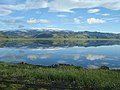
Mýrdalsjökull

Mýrdalsjökull (pronounced
The icecap of the glacier covers an active
The Eldgjá, a volcanic eruption fissure about 30 km (19 mi) long, which erupted in the year 939, is part of the same volcanic system.[3]
Before the Hringvegur (the main ring road round the island) was built, people feared traversing the plains in front of the volcano because of the frequent jökulhlaups (glacial floods) and the deep rivers to be crossed, although the road is still vulnerable to major events. Especially dangerous was the glacial flood after the eruption of 1918 when the coastline was extended by 5 km (3.1 mi) by laharic flood deposits.
Mýrdalsjökull is an exceedingly wet location, with models suggesting it receives more than 10 metres of precipitation annually.[4]
-
-
 Mýrdalsjökull
 -
 An "ice castle" formation on Mýrdalsjökull
 -
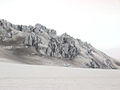
 Mýrdalsjökull glacier covered volcanic ash
 -
 Outlet glacier Sólheimajökull


See also
- Geography of Iceland
- Glaciers of Iceland
- Iceland plume
- List of lakes in Iceland
- List of islands of Iceland
- List of volcanoes in Iceland
- List of rivers of Iceland
- Volcanism of Iceland
- Waterfalls of Iceland
- List of glaciers
References
- ISSN 0022-1430.
- ISBN 978-94-6239-207-6, retrieved 2024-04-26
- S2CID 202923626.
- ^ "Late Holocene Glacial History of Sólheimajökull, Southern Iceland" (PDF). Archived from the original (PDF) on 2014-03-20.
External links
- http://www.nimbus.it/glaciorisk/Glacier_view.asp?IdGlacier=3965&Vista=paese&Paese=Iceland&IdTipoRischio= (Details of all known Glacier Runs from Mýrdalsjökull)
- http://isafold.de/strutstigur02/img_jokull.htm (Photo of Mýrdalsjökull)
- https://web.archive.org/web/20040504154433/http://volcano.und.edu/vwdocs/volc_images/europe_west_asia/eldgja.html (Volcanism)
- Katla: eruption preparedness for tourists
63°40′N 19°06′W / 63.667°N 19.100°W
This article about a glacier in Iceland is a stub. You can help Wikipedia by expanding it. |