
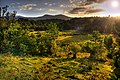
Mahdia, Guyana
Mahdia | |
|---|---|
Town and regional capital | |
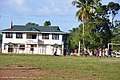
 Commercial area in Mahdia, May 2006 | |
 Mahdia Location in Guyana | |
| Coordinates: 05°16′57″N 59°09′00″W / 5.28250°N 59.15000°W | |
| Country | |
| Region | Potaro-Siparuni |
| Elevation | 1,360 ft (415 m) |
| Population (2012)[1] | |
| • Total | 2,563 |
Mahdia is a town in Guyana,[2] located near the centre of the country at an altitude of 415 m (1,362 ft).
Commerce is centred on the area's gold and diamond mining operations. As such it is affected by the economic booms and busts and attracts immigrants, both local and foreign, to obtain wealth through mining.
Demographics
The population in Mahdia as of 2012 was 2,563 people,
- A cottage hospital
- A nursery, primary and a secondary school
- A commercial sector which includes dry goods, boutiques, a fuel station and 11 restaurants.
- Four hotels; two guest houses and four brothels
- A police station
- A post office
- Two artesian wells
- A Regional Administrative Office
- An airstrip
Residents still depend on rainfall and water from the Salbora Falls. While electricity is currently provided by local businessmen.
History
Mahdia was established in 1884, by the Africans after their emancipation. Most of them travelled from the county of Berbice and the East Coast of Demerara in search of gold. The British Consolidated Mining Company, expanded the mining exploration in Mahdia and established, Colonial Administrative offices. During this period Mahdia was only accessible by waterways.
Gold mining attracted a number of St. Lucians to Mahdia, bringing with them the French Patois (Kweol) language and cultural traditions such as La Rose celebration.[5]
In November 1933 a bridge was constructed over the Garraway Stream, linking Mahdia to Bartica by trail. This bridge which is suspended by cables was named the
In May 2023, a fire destroyed a local secondary school dormitory, killing at least 19 students.[8]
Mining
There are 150 land dredges in the mining district of Mahdia. Most miners use excavators to extract the
Climate
Mahdia has a tropical rainforest climate (Af) with heavy to very heavy rainfall year-round.
| Climate data for Mahdia | |||||||||||||
|---|---|---|---|---|---|---|---|---|---|---|---|---|---|
| Month | Jan | Feb | Mar | Apr | May | Jun | Jul | Aug | Sep | Oct | Nov | Dec | Year |
| Mean daily maximum °C (°F) | 29.6 (85.3) |
29.7 (85.5) |
30.1 (86.2) |
30.7 (87.3) |
30.8 (87.4) |
30.5 (86.9) |
30.5 (86.9) |
31.1 (88.0) |
31.6 (88.9) |
31.6 (88.9) |
31.0 (87.8) |
30.2 (86.4) |
30.6 (87.1) |
| Daily mean °C (°F) | 25.5 (77.9) |
25.6 (78.1) |
26.0 (78.8) |
26.5 (79.7) |
26.9 (80.4) |
26.5 (79.7) |
26.4 (79.5) |
27.0 (80.6) |
27.3 (81.1) |
27.3 (81.1) |
26.8 (80.2) |
26.1 (79.0) |
26.5 (79.7) |
| Mean daily minimum °C (°F) | 21.4 (70.5) |
21.5 (70.7) |
21.9 (71.4) |
22.4 (72.3) |
23.0 (73.4) |
22.5 (72.5) |
22.4 (72.3) |
22.9 (73.2) |
23.1 (73.6) |
23.1 (73.6) |
22.6 (72.7) |
22.0 (71.6) |
22.4 (72.3) |
| Average rainfall mm (inches) | 269 (10.6) |
185 (7.3) |
185 (7.3) |
232 (9.1) |
364 (14.3) |
418 (16.5) |
326 (12.8) |
263 (10.4) |
114 (4.5) |
93 (3.7) |
140 (5.5) |
237 (9.3) |
2,826 (111.3) |
| Source: Climate-Data.org[9] | |||||||||||||
Gallery
-
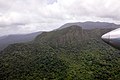 Some Peaks Close to Mahdia
 -
-
 Mahdia Police Station
 -
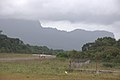 Mahdia Airstrip


References
- ^ a b "2012 Population by Village". Statistics Guyana. Archived from the original on 17 April 2021. Retrieved 15 August 2020.
- ^ "Capital towns and economic development". Ministry of Communities. Archived from the original on 1 February 2019. Retrieved 18 August 2020.
- ^ "Campbelltown to host Heritage Day activities on September 28/29". Guyana Chronicle. Archived from the original on 21 July 2022. Retrieved 9 September 2020.
- ^ "The La Rose festival of St Lucia". Stabroek News. Retrieved 9 September 2020.
- ^ "The La Rose festival of St Lucia". Stabroek News. 29 September 2013. Retrieved 16 January 2021.
- ^ "Region 8 (Potaro-Siparuni". National Trust. Archived from the original on 28 April 2021. Retrieved 9 September 2020.
- ^ "Mahdia declared Guyana's 10th town". Stabroek News. 26 October 2018. Retrieved 17 August 2020.
- from the original on 22 May 2023. Retrieved 22 May 2023.
- ^ "Climate:Mahdia". Climate-Data.org. Retrieved 13 August 2020.
- Daly, V.T. The Making of Guyana. 1974.
- Fernandes, L.L. Report May – December, 1974, Mcdame Exploration Ltd.
- Woolford William. Booklet For Guyana Geology And Mines Commission, March 2008.
| International | |
|---|---|
| Other | |